Property Record
40600 Ne 221St Ave, Amboy, WA 98601


NEARBY LISTINGS FOR SALE OR LEASE
-
-
View all Amboy listings for sale on LoopNet.com
Property Detail
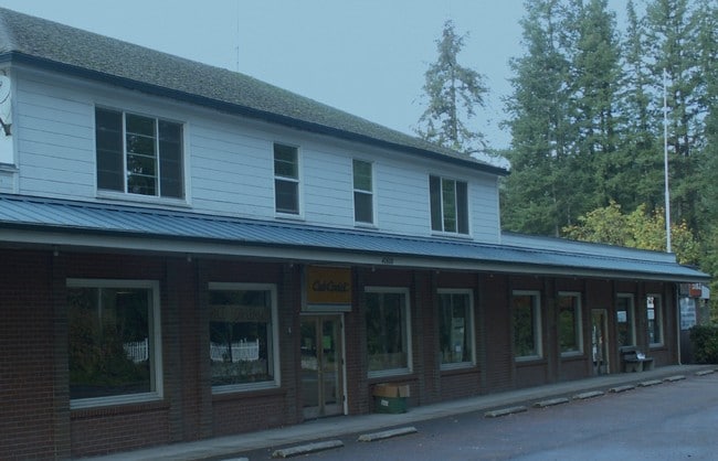
40600 Ne 221St Ave
275267-000
#49 SEC 16 T5NR3EWM 2.30A FOR ASSESSOR USE ONLY BEG AT NE COR OF SD NWQ OF SWQ TH S0-16-52W ALG E LI THOF 845.75 FT TO C/L OF A PRIV RD PER BK 143 PG 387 & BG SE COR OF TT CVYD TO D A GILLIES TH N0-16-52E ALG SD E LI 400 FT TH S83-37-37W 250 FT TH S0
Storemultistory
Clark
X
Washington
53011C0125E
2.30 AC
2025
Clark County Outlying
2025
Portland
040101
Portland-Vancouver-Hillsboro, OR-WA
11,059 SF
DEMOGRAPHICS near 40600 Ne 221St Ave
1 Mile
3 Mile
5 Mile
2024 Total Population
559
3,469
8,804
2029 Population
593
3,683
9,369
Pop Growth 2024-2029
+ 6.08%
+ 6.17%
+ 6.42%
Average Age
39
39
38
2024 Total Households
178
1,094
2,739
HH Growth 2024-2029
+ 6.18%
+ 6.31%
+ 6.50%
Median Household Inc
$79,891
$85,869
$87,164
Avg Household Size
3.00
3.00
3.10
2024 Avg HH Vehicles
3.00
3.00
3.00
Median Home Value
$557,229
$574,416
$505,088
Median Year Built
1990
1990
1991
Nearby Places
Map Layers
Map Styles
 Street
 Aerial
- Restaurants
- Banks
- Shops
- Fitness
- Groceries
PUBLIC TRANSPORTATION
AIRPORT
Portland International
DRIVE
WALK
Distance
Portland International
48 min
30.9 mi
Freight Ports
Port of Kalama, WA
DRIVE
WALK
Distance
Port of Kalama, WA
40 min
25.4 mi
SALE & LEASE HISTORY
LISTING DATE
SALE/LEASE

Nov 15, 2018
For Sale
Nearby Properties
Address
Land Use
TOTAL SIZE
Lot Size
Zoning
Address
Land Use
TOTAL SIZE
Lot Size
Zoning
289,528 SF
25.04 AC
R-5
Address
Land Use
TOTAL SIZE
Lot Size
Zoning
322.94 AC
FR-80
Address
Land Use
TOTAL SIZE
Lot Size
Zoning
5,000 SF
5 AC
AG-20
Address
Land Use
TOTAL SIZE
Lot Size
Zoning
3,850 SF
47 AC
FR-40
Address
Land Use
TOTAL SIZE
Lot Size
Zoning
13,866 SF
0.50 AC
CR-2
Address
Land Use
TOTAL SIZE
Lot Size
Zoning
4,546 SF
0.47 AC
CR-2
Address
Land Use
TOTAL SIZE
Lot Size
Zoning
2,668 SF
2.89 AC
CR-2
Address
Land Use
TOTAL SIZE
Lot Size
Zoning
10 SF
2.07 AC
AG-20
Address
Land Use
TOTAL SIZE
Lot Size
Zoning
2,324 SF
14.18 AC
P/WL
Address
Land Use
TOTAL SIZE
Lot Size
Zoning
5,840 SF
0.93 AC
PF
Address
Land Use
TOTAL SIZE
Lot Size
Zoning
40 AC
FR-80
Address
Land Use
TOTAL SIZE
Lot Size
Zoning
1 SF
0.23 AC
AG-20
Address
Land Use
TOTAL SIZE
Lot Size
Zoning
1,597 SF
20.50 AC
FR-40
Address
Land Use
TOTAL SIZE
Lot Size
Zoning
39.47 AC
FR-40
Address
Land Use
TOTAL SIZE
Lot Size
Zoning
10 AC
R-10
Address
Land Use
TOTAL SIZE
Lot Size
Zoning
366 SF
12 AC
R-10
Address
Land Use
TOTAL SIZE
Lot Size
Zoning
36.40 AC
FR-40
Address
Land Use
TOTAL SIZE
Lot Size
Zoning
8.26 AC
R-10
Address
Land Use
TOTAL SIZE
Lot Size
Zoning
10.73 AC
AG-20
Address
Land Use
TOTAL SIZE
Lot Size
Zoning
520 SF
10 AC
R-10
Address
Land Use
TOTAL SIZE
Lot Size
Zoning
2,744 SF
13.18 AC
FR-40
Address
Land Use
TOTAL SIZE
Lot Size
Zoning
8,420 SF
0.78 AC
R-5
Address
Land Use
TOTAL SIZE
Lot Size
Zoning
15 AC
FR-40
Address
Land Use
TOTAL SIZE
Lot Size
Zoning
10.04 AC
R-10
Address
Land Use
TOTAL SIZE
Lot Size
Zoning
3,920 SF
0.34 AC
CR-2
Address
Land Use
TOTAL SIZE
Lot Size
Zoning
1,680 SF
10 AC
AG-20
Address
Land Use
TOTAL SIZE
Lot Size
Zoning
11 AC
R-10
The World's #1 Commercial Real Estate Marketplace
Connect with us
© 2026 CoStar Group
The information above has been obtained from sources believed reliable. While we do not doubt its accuracy we have not verified it and make no guarantee, warranty or representation about it. It is your responsibility to independently confirm its accuracy and completeness. Any projections, opinions, assumptions, or estimates used are for example only and do not represent the current or future performance of the property. The value of this transaction to you depends on tax and other factors which should be evaluated by your tax, financial, and legal advisors. You and your advisors should conduct a careful, independent investigation of the property to determine to your satisfaction the suitability of the property for your needs.