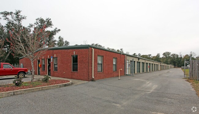
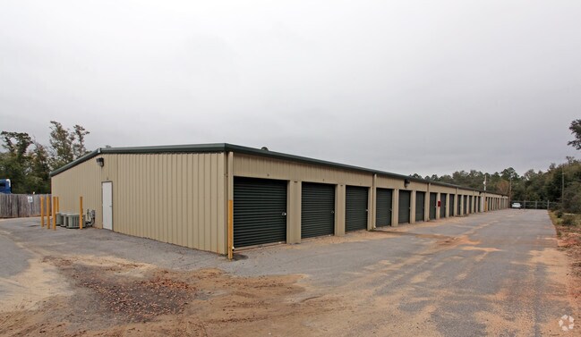
Property Record
4065 Garcon Point Rd, Milton, FL 32583


Property Detail
4065 Garcon Point Rd
22-1N-28-0000-03600-0000
PARCEL A: COM AT NE CORN OF SEC TH S 01*04'15 W 13 19.92 FT TH CONT S 264 FT TH N 89*44'16 W 52.18 FT TO W R/W OF GARCON POINT RD & POB TH S 01*24'07 W 527.30 FT TH N 89*48'39 W 599.93 FT TH N 5 28 FT TH S 89*44'16 E 604.11 FT TO POB & ALSO PARCEL B:
Publicstorage
Santa Rosa
HCD
Florida
B and X Area of moderate flood hazard, usually the area between the limits of the 100-year and 500-year floods.
7.90 AC
2025
Avalon Beach/Milton
2025
Pensacola
010709
Pensacola-Ferry Pass-Brent, FL
42,160 SF
NEARBY LISTINGS FOR SALE OR LEASE
-
-
View all Milton listings for sale on LoopNet.com
DEMOGRAPHICS near 4065 Garcon Point Rd
1 mile
3 mile
5 mile
2025 Total Population
2,072
10,983
41,375
2030 Population
2,262
11,994
44,994
Pop Growth 2025-2030
+ 9.17%
+ 9.21%
+ 8.75%
Average Age
42
41
41
2025 Total Households
795
4,261
15,848
HH Growth 2025-2030
+ 8.81%
+ 9.06%
+ 8.59%
Median Household Inc
$84,221
$81,813
$77,995
Avg Household Size
2.50
2.50
2.50
2025 Avg HH Vehicles
2.00
2.00
2.00
Median Home Value
$251,121
$252,113
$266,030
Median Year Built
2002
1995
1993
Nearby Places
Map Layers
Map Styles
 Street
 Aerial
Layers
 Traffic
 Biking
Places
Listings with unknown addresses are not visible on the map
- Restaurants
- Banks
- Shops
- Fitness
- Groceries
PUBLIC TRANSPORTATION
AIRPORT
Pensacola International
Drive
Walk
Distance
Pensacola International
27 min
17.3 mi
Freight Ports
Port of Mobile
Drive
Walk
Distance
Port of Mobile
76 min
67.3 mi
Nearby Properties
Address
Land Use
TOTAL SIZE
Lot Size
Zoning
Address
Land Use
TOTAL SIZE
Lot Size
Zoning
113,178 SF
8.61 AC
HCD
Address
Land Use
TOTAL SIZE
Lot Size
Zoning
151,842 SF
14.28 AC
C2
Address
Land Use
TOTAL SIZE
Lot Size
Zoning
113,652 SF
9.52 AC
C2
Address
Land Use
TOTAL SIZE
Lot Size
Zoning
82,878 SF
9.07 AC
HCD
Address
Land Use
TOTAL SIZE
Lot Size
Zoning
98,250 SF
49.63 AC
HCD
Address
Land Use
TOTAL SIZE
Lot Size
Zoning
68,026 SF
2.07 AC
RC1
Address
Land Use
TOTAL SIZE
Lot Size
Zoning
48,210 SF
8.98 AC
C2
Address
Land Use
TOTAL SIZE
Lot Size
Zoning
16,903 SF
11 AC
AG-RR
Address
Land Use
TOTAL SIZE
Lot Size
Zoning
37,820 SF
16.98 AC
HCD
Address
Land Use
TOTAL SIZE
Lot Size
Zoning
41,105 SF
8.16 AC
HCD
Address
Land Use
TOTAL SIZE
Lot Size
Zoning
43,312 SF
15 AC
HCD
Address
Land Use
TOTAL SIZE
Lot Size
Zoning
60,717 SF
4.43 AC
HCD
Address
Land Use
TOTAL SIZE
Lot Size
Zoning
26,200 SF
7.74 AC
HCD
Address
Land Use
TOTAL SIZE
Lot Size
Zoning
77,589 SF
9.39 AC
HCD
Address
Land Use
TOTAL SIZE
Lot Size
Zoning
24,801 SF
2.32 AC
C2
Address
Land Use
TOTAL SIZE
Lot Size
Zoning
25,264 SF
3.72 AC
C2
Address
Land Use
TOTAL SIZE
Lot Size
Zoning
4.33 AC
HR1
Address
Land Use
TOTAL SIZE
Lot Size
Zoning
38,797 SF
2.81 AC
R2
Address
Land Use
TOTAL SIZE
Lot Size
Zoning
9,058 SF
8.35 AC
I1
Address
Land Use
TOTAL SIZE
Lot Size
Zoning
55,416 SF
4.96 AC
C2
Address
Land Use
TOTAL SIZE
Lot Size
Zoning
16,009 SF
8.69 AC
HCD
Address
Land Use
TOTAL SIZE
Lot Size
Zoning
44,028 SF
8.73 AC
C2
Address
Land Use
TOTAL SIZE
Lot Size
Zoning
48,158 SF
4.72 AC
HCD
Address
Land Use
TOTAL SIZE
Lot Size
Zoning
17,354 SF
0.88 AC
C2
Address
Land Use
TOTAL SIZE
Lot Size
Zoning
14,800 SF
44.73 AC
M1
Address
Land Use
TOTAL SIZE
Lot Size
Zoning
25,034 SF
11.55 AC
HCD
Address
Land Use
TOTAL SIZE
Lot Size
Zoning
20,113 SF
1.42 AC
C2
Address
Land Use
TOTAL SIZE
Lot Size
Zoning
16,516 SF
5.27 AC
C2
Address
Land Use
TOTAL SIZE
Lot Size
Zoning
930 SF
118.07 AC
M2
The World's #1 Commercial Real Estate Marketplace
Connect with us
© 2026 CoStar Group
The information above has been obtained from sources believed reliable. While we do not doubt its accuracy we have not verified it and make no guarantee, warranty or representation about it. It is your responsibility to independently confirm its accuracy and completeness. Any projections, opinions, assumptions, or estimates used are for example only and do not represent the current or future performance of the property. The value of this transaction to you depends on tax and other factors which should be evaluated by your tax, financial, and legal advisors. You and your advisors should conduct a careful, independent investigation of the property to determine to your satisfaction the suitability of the property for your needs.