No Photo
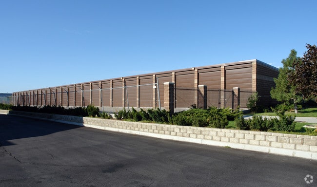
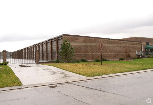
Property Record
4065 W Nike Dr, West Jordan, UT 84088
Property Detail
4065 W Nike Dr
21-31-428-020-0000
UNIT 2, U-OWN IT STORAGE CONDOMINIUM. 7708-1626
Industrialcondominium
Salt Lake
M-1
Utah
B and X Area of moderate flood hazard, usually the area between the limits of the 100-year and 500-year floods.
0.01 AC
2024
Southwest Valley
2025
Salt Lake City
113101
Salt Lake City-Murray, UT
480 SF
NEARBY LISTINGS FOR SALE OR LEASE
-
-
View all West Jordan listings for sale on LoopNet.com
DEMOGRAPHICS near 4065 W Nike Dr
1 mile
3 mile
5 mile
2025 Total Population
9,937
131,171
334,677
2030 Population
10,159
134,741
345,825
Pop Growth 2025-2030
+ 2.23%
+ 2.72%
+ 3.33%
Average Age
36
36
36
2025 Total Households
2,868
38,935
101,976
HH Growth 2025-2030
+ 2.37%
+ 2.84%
+ 3.48%
Median Household Inc
$110,679
$110,178
$105,976
Avg Household Size
3.40
3.30
3.20
2025 Avg HH Vehicles
2.00
2.00
2.00
Median Home Value
$476,859
$523,800
$526,320
Median Year Built
1991
1995
1997
Nearby Places
Map Layers
Map Styles
 Street
 Aerial
Layers
 Traffic
 Biking
Places
Listings with unknown addresses are not visible on the map
- Restaurants
- Banks
- Shops
- Fitness
- Groceries
PUBLIC TRANSPORTATION
COMMUTER RAIL
South Jordan Station (FrontRunner - Utah Transit Authority (UTA))
Drive
Walk
Distance
South Jordan Station (FrontRunner - Utah Transit Authority (UTA))
15 min
7.1 mi
AIRPORT
Salt Lake City International
Drive
Walk
Distance
Salt Lake City International
22 min
13.5 mi
Freight Ports
Port of Stockton
Drive
Walk
Distance
Port of Stockton
720 min
697.4 mi
Nearby Properties
Address
Land Use
TOTAL SIZE
Lot Size
Zoning
Address
Land Use
TOTAL SIZE
Lot Size
Zoning
733,215 SF
58.65 AC
M-1
Address
Land Use
TOTAL SIZE
Lot Size
Zoning
338,177 SF
21.91 AC
M-1
Address
Land Use
TOTAL SIZE
Lot Size
Zoning
233,853 SF
6.05 AC
HFR
Address
Land Use
TOTAL SIZE
Lot Size
Zoning
198,801 SF
8.36 AC
R-3-20
Address
Land Use
TOTAL SIZE
Lot Size
Zoning
308,722 SF
21.29 AC
M-1
Address
Land Use
TOTAL SIZE
Lot Size
Zoning
187.81 AC
P-F
Address
Land Use
TOTAL SIZE
Lot Size
Zoning
362,000 SF
51.81 AC
P-F
Address
Land Use
TOTAL SIZE
Lot Size
Zoning
308,722 SF
20.45 AC
M-1
Address
Land Use
TOTAL SIZE
Lot Size
Zoning
256,167 SF
13.56 AC
P-C
Address
Land Use
TOTAL SIZE
Lot Size
Zoning
410,435 SF
2.43 AC
P-C
Address
Land Use
TOTAL SIZE
Lot Size
Zoning
256,933 SF
19.68 AC
P-C
Address
Land Use
TOTAL SIZE
Lot Size
Zoning
77,525 SF
2.35 AC
P-C
Address
Land Use
TOTAL SIZE
Lot Size
Zoning
114.79 AC
PF
Address
Land Use
TOTAL SIZE
Lot Size
Zoning
143,314 SF
2.30 AC
P-C
Address
Land Use
TOTAL SIZE
Lot Size
Zoning
425,753 SF
2.28 AC
PC
Address
Land Use
TOTAL SIZE
Lot Size
Zoning
28,515 SF
6.77 AC
PC
Address
Land Use
TOTAL SIZE
Lot Size
Zoning
536,706 SF
12.80 AC
SC-2
Address
Land Use
TOTAL SIZE
Lot Size
Zoning
40,042 SF
15.43 AC
R-3-16
Address
Land Use
TOTAL SIZE
Lot Size
Zoning
203,064 SF
5.91 AC
PC
Address
Land Use
TOTAL SIZE
Lot Size
Zoning
836,998 SF
14.25 AC
SC-2
Address
Land Use
TOTAL SIZE
Lot Size
Zoning
120,929 SF
7.23 AC
PC
Address
Land Use
TOTAL SIZE
Lot Size
Zoning
554,777 SF
168.76 AC
M-1
Address
Land Use
TOTAL SIZE
Lot Size
Zoning
76,837 SF
50.54 AC
P-F
Address
Land Use
TOTAL SIZE
Lot Size
Zoning
268,200 SF
44.38 AC
PF
Address
Land Use
TOTAL SIZE
Lot Size
Zoning
411,226 SF
7.22 AC
SC-2
Address
Land Use
TOTAL SIZE
Lot Size
Zoning
36,708 SF
12.83 AC
R-3-16
Address
Land Use
TOTAL SIZE
Lot Size
Zoning
314,994 SF
10 AC
R-3
Address
Land Use
TOTAL SIZE
Lot Size
Zoning
105,956 SF
37.60 AC
4180
Address
Land Use
TOTAL SIZE
Lot Size
Zoning
341,646 SF
19.70 AC
M-1
Address
Land Use
TOTAL SIZE
Lot Size
Zoning
80 AC
PF
The World's #1 Commercial Real Estate Marketplace
Connect with us
© 2026 CoStar Group
The information above has been obtained from sources believed reliable. While we do not doubt its accuracy we have not verified it and make no guarantee, warranty or representation about it. It is your responsibility to independently confirm its accuracy and completeness. Any projections, opinions, assumptions, or estimates used are for example only and do not represent the current or future performance of the property. The value of this transaction to you depends on tax and other factors which should be evaluated by your tax, financial, and legal advisors. You and your advisors should conduct a careful, independent investigation of the property to determine to your satisfaction the suitability of the property for your needs.