Property Record
4066 Red Arrow Hwy, Saint Joseph, MI 49085
NEARBY LISTINGS FOR SALE OR LEASE
-
-
View all Saint Joseph listings for sale on LoopNet.com
Property Detail
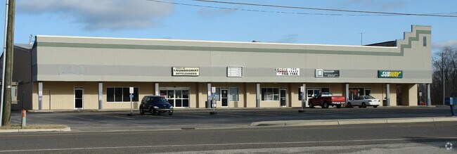
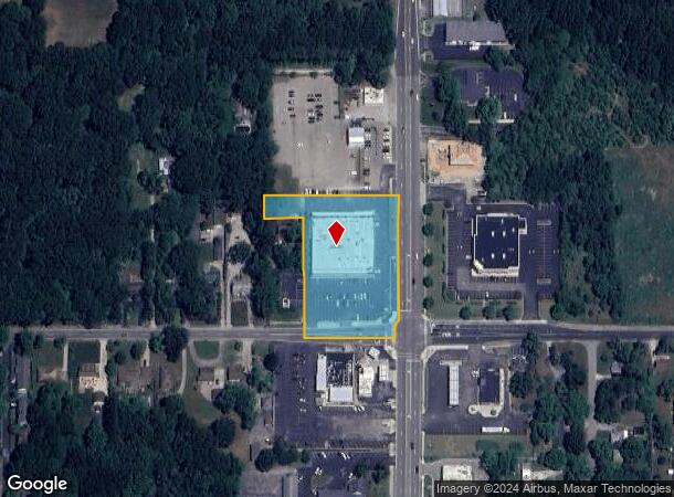
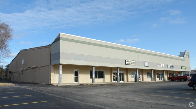
4066 Red Arrow Hwy
11-12-0009-0015-05-1
BEG 75.71' N89DEG56'12W OF THE SE COR SEC 9 T5S R19W TH NODEG03'48"E 33' TH N42DEG37'01"E 37.68' TH N 315.24' TH W 333' TH S 58' TH E 100' TH S318' TH E 207.29' TO POB
Stripcommercialcenter
Berrien
X
Michigan
26021C0092D
2.11 AC
2024
Michigan Southwest Area
2025
Other Market Areas
001500
Niles-Benton Harbor, MI
20,164 SF
DEMOGRAPHICS near 4066 Red Arrow Hwy
1 Mile
3 Mile
5 Mile
2024 Total Population
3,206
19,622
38,049
2029 Population
3,155
19,173
37,188
Pop Growth 2024-2029
(1.59%)
(2.29%)
(2.26%)
Average Age
44
44
43
2024 Total Households
1,484
8,246
16,351
HH Growth 2024-2029
(1.75%)
(2.41%)
(2.41%)
Median Household Inc
$72,523
$86,685
$78,520
Avg Household Size
2.10
2.30
2.30
2024 Avg HH Vehicles
2.00
2.00
2.00
Median Home Value
$273,673
$253,301
$234,059
Median Year Built
1975
1972
1966
Nearby Places
Map Layers
Map Styles
 Street
 Aerial
- Restaurants
- Banks
- Shops
- Fitness
- Groceries
PUBLIC TRANSPORTATION
COMMUTER RAIL
DRIVE
WALK
Distance
10 min
5.5 mi
AIRPORT
South Bend International
DRIVE
WALK
Distance
South Bend International
51 min
32.9 mi
Nearby Properties
Address
Land Use
TOTAL SIZE
Lot Size
Zoning
Address
Land Use
TOTAL SIZE
Lot Size
Zoning
Address
Land Use
TOTAL SIZE
Lot Size
Zoning
125,408 SF
4.66 AC
R-3
Address
Land Use
TOTAL SIZE
Lot Size
Zoning
87,978 SF
4.36 AC
R2 MDR
Address
Land Use
TOTAL SIZE
Lot Size
Zoning
21,824 SF
21.15 AC
CR
Address
Land Use
TOTAL SIZE
Lot Size
Zoning
73,680 SF
CO-A
Address
Land Use
TOTAL SIZE
Lot Size
Zoning
195,253 SF
25.72 AC
HC
Address
Land Use
TOTAL SIZE
Lot Size
Zoning
53,504 SF
Address
Land Use
TOTAL SIZE
Lot Size
Zoning
330,000 SF
20.56 AC
I1
Address
Land Use
TOTAL SIZE
Lot Size
Zoning
28,312 SF
4.30 AC
C
Address
Land Use
TOTAL SIZE
Lot Size
Zoning
45,270 SF
10.30 AC
C1 GEN COM
Address
Land Use
TOTAL SIZE
Lot Size
Zoning
150,421 SF
10.30 AC
HD
Address
Land Use
TOTAL SIZE
Lot Size
Zoning
519,203 SF
25.57 AC
C
Address
Land Use
TOTAL SIZE
Lot Size
Zoning
25,080 SF
I-1
Address
Land Use
TOTAL SIZE
Lot Size
Zoning
58,580 SF
1.99 AC
HC
Address
Land Use
TOTAL SIZE
Lot Size
Zoning
403,396 SF
37.17 AC
HI
Address
Land Use
TOTAL SIZE
Lot Size
Zoning
54,750 SF
5.87 AC
CMU
Address
Land Use
TOTAL SIZE
Lot Size
Zoning
89,420 SF
7.89 AC
R3 - SINGL
Address
Land Use
TOTAL SIZE
Lot Size
Zoning
39,473 SF
2.90 AC
CO-A
Address
Land Use
TOTAL SIZE
Lot Size
Zoning
60,252 SF
3.17 AC
C
Address
Land Use
TOTAL SIZE
Lot Size
Zoning
62,721 SF
16.85 AC
CMU
Address
Land Use
TOTAL SIZE
Lot Size
Zoning
Address
Land Use
TOTAL SIZE
Lot Size
Zoning
49,162 SF
3.04 AC
HC
Address
Land Use
TOTAL SIZE
Lot Size
Zoning
67,200 SF
3.90 AC
R-3
Address
Land Use
TOTAL SIZE
Lot Size
Zoning
0.99 AC
SELECTZONI
Address
Land Use
TOTAL SIZE
Lot Size
Zoning
63,134 SF
4.90 AC
B2 - RET/S
Address
Land Use
TOTAL SIZE
Lot Size
Zoning
143,186 SF
6.44 AC
I-1
Address
Land Use
TOTAL SIZE
Lot Size
Zoning
121,500 SF
16.54 AC
I1
Address
Land Use
TOTAL SIZE
Lot Size
Zoning
128,076 SF
29.98 AC
LD
Address
Land Use
TOTAL SIZE
Lot Size
Zoning
Address
Land Use
TOTAL SIZE
Lot Size
Zoning
25,029 SF
4.22 AC
B2 - RET/S
The World's #1 Commercial Real Estate Marketplace
Connect with us
© 2025 CoStar Group
The information above has been obtained from sources believed reliable. While we do not doubt its accuracy we have not verified it and make no guarantee, warranty or representation about it. It is your responsibility to independently confirm its accuracy and completeness. Any projections, opinions, assumptions, or estimates used are for example only and do not represent the current or future performance of the property. The value of this transaction to you depends on tax and other factors which should be evaluated by your tax, financial, and legal advisors. You and your advisors should conduct a careful, independent investigation of the property to determine to your satisfaction the suitability of the property for your needs.