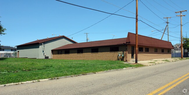
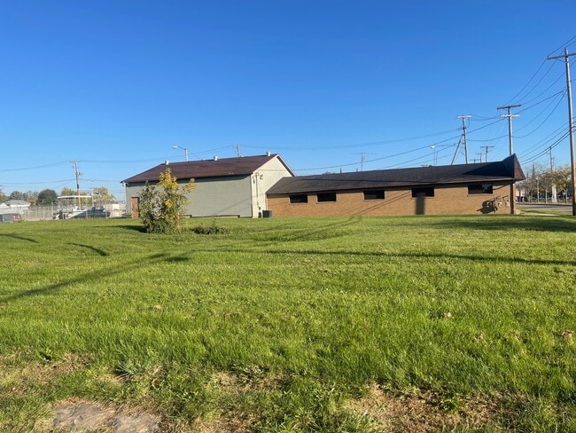
Property Record
High Ave Sw, Canton, OH 44707
NEARBY LISTINGS FOR SALE OR LEASE
Property Detail
High Ave Sw
00203663
963-75EE
Residentialacreage
Stark
X
Ohio
39151C0217E
0.09 AC
2025
Stark County
2025
Cleveland
713201
Canton-Massillon, OH
DEMOGRAPHICS near High Ave Sw
1 Mile
3 Mile
5 Mile
2024 Total Population
10,967
77,369
133,966
2029 Population
11,008
77,161
133,380
Pop Growth 2024-2029
+ 0.37%
(0.27%)
(0.44%)
Average Age
37
39
41
2024 Total Households
4,726
33,018
57,649
HH Growth 2024-2029
+ 0.30%
(0.32%)
(0.46%)
Median Household Inc
$27,016
$40,461
$46,382
Avg Household Size
2.10
2.20
2.20
2024 Avg HH Vehicles
1.00
2.00
2.00
Median Home Value
$57,899
$88,905
$126,720
Median Year Built
1947
1949
1956
Nearby Places
Map Layers
Map Styles
 Street
 Aerial
- Restaurants
- Banks
- Shops
- Fitness
- Groceries
PUBLIC TRANSPORTATION
AIRPORT
Akron-Canton Regional
DRIVE
WALK
Distance
Akron-Canton Regional
14 min
10.5 mi
Freight Ports
Port of Toledo
DRIVE
WALK
Distance
Port of Toledo
185 min
157.8 mi
SALE & LEASE HISTORY
LISTING DATE
SALE/LEASE

Nov 20, 2020
For Sale
Nearby Properties
Address
Land Use
TOTAL SIZE
Lot Size
Zoning
Address
Land Use
TOTAL SIZE
Lot Size
Zoning
86,994 SF
35.20 AC
Address
Land Use
TOTAL SIZE
Lot Size
Zoning
551,338 SF
7.26 AC
Address
Land Use
TOTAL SIZE
Lot Size
Zoning
397,897 SF
3.76 AC
Address
Land Use
TOTAL SIZE
Lot Size
Zoning
521,112 SF
14.28 AC
Address
Land Use
TOTAL SIZE
Lot Size
Zoning
356,172 SF
4.06 AC
Address
Land Use
TOTAL SIZE
Lot Size
Zoning
194,249 SF
10.90 AC
Address
Land Use
TOTAL SIZE
Lot Size
Zoning
330,693 SF
14.29 AC
Address
Land Use
TOTAL SIZE
Lot Size
Zoning
180,000 SF
Address
Land Use
TOTAL SIZE
Lot Size
Zoning
272,888 SF
27.61 AC
Address
Land Use
TOTAL SIZE
Lot Size
Zoning
327,119 SF
50.74 AC
Address
Land Use
TOTAL SIZE
Lot Size
Zoning
1,069,826 SF
158.31 AC
Address
Land Use
TOTAL SIZE
Lot Size
Zoning
194,249 SF
10.86 AC
Address
Land Use
TOTAL SIZE
Lot Size
Zoning
345,570 SF
29.76 AC
Address
Land Use
TOTAL SIZE
Lot Size
Zoning
108,197 SF
8.19 AC
Address
Land Use
TOTAL SIZE
Lot Size
Zoning
118,619 SF
2.14 AC
Address
Land Use
TOTAL SIZE
Lot Size
Zoning
117,601 SF
7.93 AC
Address
Land Use
TOTAL SIZE
Lot Size
Zoning
107,248 SF
0.09 AC
Address
Land Use
TOTAL SIZE
Lot Size
Zoning
423,783 SF
26.11 AC
Address
Land Use
TOTAL SIZE
Lot Size
Zoning
476,634 SF
15.08 AC
Address
Land Use
TOTAL SIZE
Lot Size
Zoning
316,099 SF
8.47 AC
Address
Land Use
TOTAL SIZE
Lot Size
Zoning
102,436 SF
4.95 AC
Address
Land Use
TOTAL SIZE
Lot Size
Zoning
82,950 SF
Address
Land Use
TOTAL SIZE
Lot Size
Zoning
158,390 SF
0.92 AC
Address
Land Use
TOTAL SIZE
Lot Size
Zoning
1,096,089 SF
144.96 AC
Address
Land Use
TOTAL SIZE
Lot Size
Zoning
61,884 SF
2.18 AC
Address
Land Use
TOTAL SIZE
Lot Size
Zoning
93,216 SF
4.93 AC
Address
Land Use
TOTAL SIZE
Lot Size
Zoning
180,088 SF
71.80 AC
Address
Land Use
TOTAL SIZE
Lot Size
Zoning
0.35 AC
Address
Land Use
TOTAL SIZE
Lot Size
Zoning
89,344 SF
3.77 AC
Address
Land Use
TOTAL SIZE
Lot Size
Zoning
59,211 SF
3.53 AC
The World's #1 Commercial Real Estate Marketplace
Connect with us
© 2026 CoStar Group
The information above has been obtained from sources believed reliable. While we do not doubt its accuracy we have not verified it and make no guarantee, warranty or representation about it. It is your responsibility to independently confirm its accuracy and completeness. Any projections, opinions, assumptions, or estimates used are for example only and do not represent the current or future performance of the property. The value of this transaction to you depends on tax and other factors which should be evaluated by your tax, financial, and legal advisors. You and your advisors should conduct a careful, independent investigation of the property to determine to your satisfaction the suitability of the property for your needs.