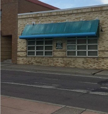
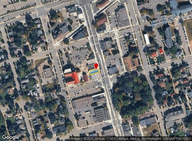
Property Record
407 N Chestnut St, Chaska, MN 55318

NEARBY LISTINGS FOR SALE OR LEASE
Property Detail
407 N Chestnut St
Minneapolis-St. Paul-Bloomington, MN-WI
Rls 114
30.5460020
TRACT B & P/O LOT 4 BLK 22 TOWN OF CHASKA DESC AS: BEG AT SE CORN LOT 4 TH S75*W 84' ON S
Dentalbldg
Carver
X
Minnesota
27019C0236D
4
2025
0.06 AC
2025
Carver County Outlying
091002
Minneapolis/St Paul
2,675 SF
DEMOGRAPHICS near 407 N Chestnut St
1 Mile
3 Mile
5 Mile
2024 Total Population
5,810
34,664
73,669
2029 Population
6,262
37,667
79,585
Pop Growth 2024-2029
+ 7.78%
+ 8.66%
+ 8.03%
Average Age
38
38
38
2024 Total Households
2,285
12,650
26,281
HH Growth 2024-2029
+ 7.48%
+ 8.58%
+ 8.12%
Median Household Inc
$70,949
$88,183
$95,752
Avg Household Size
2.40
2.70
2.70
2024 Avg HH Vehicles
2.00
2.00
2.00
Median Home Value
$296,536
$334,530
$360,138
Median Year Built
1986
1994
1996
Nearby Places
Map Layers
Map Styles
 Street
 Aerial
- Restaurants
- Banks
- Shops
- Fitness
- Groceries
PUBLIC TRANSPORTATION
AIRPORT
Minneapolis-St Paul International/Wold-Chamberlain
DRIVE
WALK
Distance
Minneapolis-St Paul International/Wold-Chamberlain
28 min
23.4 mi
Freight Ports
Port of Shreveport
DRIVE
WALK
Distance
Port of Shreveport
1 min
859.0 mi
SALE & LEASE HISTORY
LISTING DATE
SALE/LEASE

Jun 21, 2018
For Sale
Jun 20, 2018
For Lease
Jun 20, 2018
For Sale
Jan 31, 2018
For Lease
Jan 31, 2018
For Sale
Nearby Properties
Address
Land Use
TOTAL SIZE
Lot Size
Zoning
Address
Land Use
TOTAL SIZE
Lot Size
Zoning
209,623 SF
72.81 AC
Address
Land Use
TOTAL SIZE
Lot Size
Zoning
20,086 SF
12.99 AC
Address
Land Use
TOTAL SIZE
Lot Size
Zoning
Address
Land Use
TOTAL SIZE
Lot Size
Zoning
44,611 SF
9.75 AC
Address
Land Use
TOTAL SIZE
Lot Size
Zoning
20,586 SF
19.34 AC
Address
Land Use
TOTAL SIZE
Lot Size
Zoning
5.71 AC
Address
Land Use
TOTAL SIZE
Lot Size
Zoning
254,602 SF
18.19 AC
Address
Land Use
TOTAL SIZE
Lot Size
Zoning
57,769 SF
62.10 AC
Address
Land Use
TOTAL SIZE
Lot Size
Zoning
26.05 AC
Address
Land Use
TOTAL SIZE
Lot Size
Zoning
73,937 SF
23.89 AC
Address
Land Use
TOTAL SIZE
Lot Size
Zoning
20.18 AC
Address
Land Use
TOTAL SIZE
Lot Size
Zoning
65,038 SF
6.72 AC
Address
Land Use
TOTAL SIZE
Lot Size
Zoning
2.93 AC
Address
Land Use
TOTAL SIZE
Lot Size
Zoning
10,038 SF
12.21 AC
Address
Land Use
TOTAL SIZE
Lot Size
Zoning
18,980 SF
2.77 AC
Address
Land Use
TOTAL SIZE
Lot Size
Zoning
34,794 SF
9.36 AC
Address
Land Use
TOTAL SIZE
Lot Size
Zoning
10.40 AC
Address
Land Use
TOTAL SIZE
Lot Size
Zoning
17.50 AC
Address
Land Use
TOTAL SIZE
Lot Size
Zoning
Address
Land Use
TOTAL SIZE
Lot Size
Zoning
20.79 AC
Address
Land Use
TOTAL SIZE
Lot Size
Zoning
33,982 SF
0.38 AC
Address
Land Use
TOTAL SIZE
Lot Size
Zoning
183,323 SF
16.30 AC
Address
Land Use
TOTAL SIZE
Lot Size
Zoning
128,456 SF
15.85 AC
Address
Land Use
TOTAL SIZE
Lot Size
Zoning
3.75 AC
Address
Land Use
TOTAL SIZE
Lot Size
Zoning
255,630 SF
27.07 AC
Address
Land Use
TOTAL SIZE
Lot Size
Zoning
59,724 SF
10.28 AC
Address
Land Use
TOTAL SIZE
Lot Size
Zoning
61,267 SF
4.59 AC
Address
Land Use
TOTAL SIZE
Lot Size
Zoning
54,742 SF
9.80 AC
Address
Land Use
TOTAL SIZE
Lot Size
Zoning
6.32 AC
The World's #1 Commercial Real Estate Marketplace
Connect with us
© 2025 CoStar Group
The information above has been obtained from sources believed reliable. While we do not doubt its accuracy we have not verified it and make no guarantee, warranty or representation about it. It is your responsibility to independently confirm its accuracy and completeness. Any projections, opinions, assumptions, or estimates used are for example only and do not represent the current or future performance of the property. The value of this transaction to you depends on tax and other factors which should be evaluated by your tax, financial, and legal advisors. You and your advisors should conduct a careful, independent investigation of the property to determine to your satisfaction the suitability of the property for your needs.