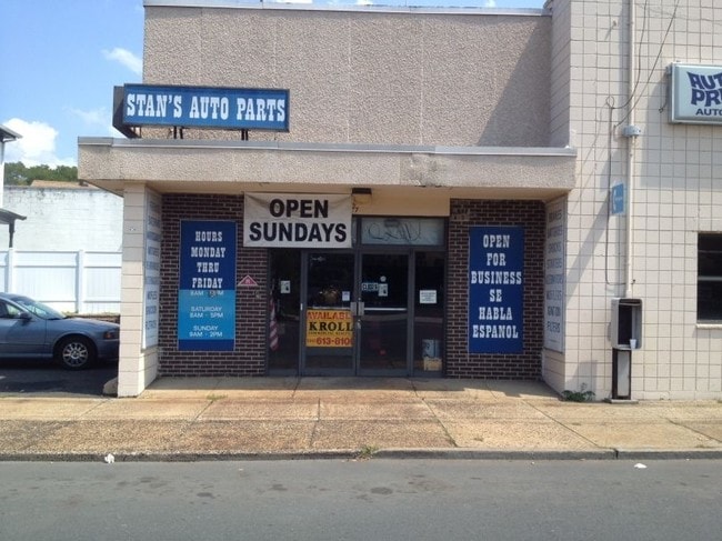
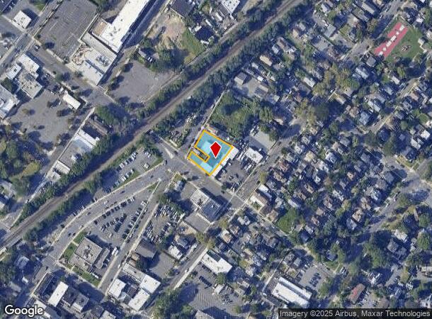
Property Record
407 Roosevelt Ave, Plainfield, NJ 07060
NEARBY LISTINGS FOR SALE OR LEASE
Property Detail
407 Roosevelt Ave
12-00606-0000-00050
ADDITIONAL LOTS: CHURCH/FACILITY NAME: CHURCH
Commercialnec
Union
X
New Jersey
34023C0031F
50
0
0.32 AC
2025
Route 22 East
039000
Northern New Jersey
5,632 SF
Newark, NJ
DEMOGRAPHICS near 407 Roosevelt Ave
1 mile
3 mile
5 mile
2024 Total Population
34,689
129,889
279,446
2029 Population
33,893
128,303
277,390
Pop Growth 2024-2029
(2.29%)
(1.22%)
(0.74%)
Average Age
36
39
40
2024 Total Households
10,309
41,673
93,173
HH Growth 2024-2029
(2.40%)
(1.22%)
(0.77%)
Median Household Inc
$62,580
$95,062
$117,966
Avg Household Size
3.20
3.00
2.90
2024 Avg HH Vehicles
1.00
2.00
2.00
Median Home Value
$341,944
$416,860
$502,643
Median Year Built
1948
1955
1962
Nearby Places
Map Layers
Map Styles
 Street
 Aerial
Transit
 Traffic
 Biking
Places
Listings with unknown addresses are not visible on the map
- Restaurants
- Banks
- Shops
- Fitness
- Groceries
PUBLIC TRANSPORTATION
COMMUTER RAIL
Plainfield (Raritan Valley Line - NJ Transit Commuter Rail (NJ Transit))
Drive
Walk
Distance
Plainfield (Raritan Valley Line - NJ Transit Commuter Rail (NJ Transit))
1 min
7 min
0.3 mi
Netherwood (Raritan Valley Line - NJ Transit Commuter Rail (NJ Transit))
Drive
Walk
Distance
Netherwood (Raritan Valley Line - NJ Transit Commuter Rail (NJ Transit))
3 min
19 min
1.0 mi
AIRPORT
Newark Liberty International
Drive
Walk
Distance
Newark Liberty International
31 min
20.6 mi
LaGuardia
Drive
Walk
Distance
LaGuardia
66 min
39.8 mi
Trenton Mercer
Drive
Walk
Distance
Trenton Mercer
65 min
39.9 mi
Freight Ports
New York Container Terminal
Drive
Walk
Distance
New York Container Terminal
35 min
17.8 mi
Nearby Properties
Address
Land Use
TOTAL SIZE
Lot Size
Zoning
Address
Land Use
TOTAL SIZE
Lot Size
Zoning
20.08 AC
RML1
Address
Land Use
TOTAL SIZE
Lot Size
Zoning
26.87 AC
H-D
Address
Land Use
TOTAL SIZE
Lot Size
Zoning
10.09 AC
Address
Land Use
TOTAL SIZE
Lot Size
Zoning
27.70 AC
Address
Land Use
TOTAL SIZE
Lot Size
Zoning
47.69 AC
MU
Address
Land Use
TOTAL SIZE
Lot Size
Zoning
47.80 AC
H-D
Address
Land Use
TOTAL SIZE
Lot Size
Zoning
15.79 AC
H-D
Address
Land Use
TOTAL SIZE
Lot Size
Zoning
12.47 AC
H-D
Address
Land Use
TOTAL SIZE
Lot Size
Zoning
19.84 AC
Address
Land Use
TOTAL SIZE
Lot Size
Zoning
16.97 AC
Address
Land Use
TOTAL SIZE
Lot Size
Zoning
30.80 AC
R10
Address
Land Use
TOTAL SIZE
Lot Size
Zoning
4.74 AC
NC
Address
Land Use
TOTAL SIZE
Lot Size
Zoning
19.84 AC
H-D
Address
Land Use
TOTAL SIZE
Lot Size
Zoning
30.40 AC
PR
Address
Land Use
TOTAL SIZE
Lot Size
Zoning
19.19 AC
R-3
Address
Land Use
TOTAL SIZE
Lot Size
Zoning
21.53 AC
H-D
Address
Land Use
TOTAL SIZE
Lot Size
Zoning
122,820 SF
14.65 AC
H-D
Address
Land Use
TOTAL SIZE
Lot Size
Zoning
12.52 AC
H-D
Address
Land Use
TOTAL SIZE
Lot Size
Zoning
21.60 AC
M3
Address
Land Use
TOTAL SIZE
Lot Size
Zoning
11.20 AC
Address
Land Use
TOTAL SIZE
Lot Size
Zoning
0.39 AC
R5
Address
Land Use
TOTAL SIZE
Lot Size
Zoning
11.02 AC
Address
Land Use
TOTAL SIZE
Lot Size
Zoning
12.06 AC
Address
Land Use
TOTAL SIZE
Lot Size
Zoning
Address
Land Use
TOTAL SIZE
Lot Size
Zoning
87,778 SF
1.88 AC
Address
Land Use
TOTAL SIZE
Lot Size
Zoning
Address
Land Use
TOTAL SIZE
Lot Size
Zoning
4,900 SF
Address
Land Use
TOTAL SIZE
Lot Size
Zoning
39,840 SF
10.97 AC
LI1
Address
Land Use
TOTAL SIZE
Lot Size
Zoning
3.68 AC
R-7
Address
Land Use
TOTAL SIZE
Lot Size
Zoning
57,710 SF
5.85 AC
H-D
The World's #1 Commercial Real Estate Marketplace
Connect with us
© 2026 CoStar Group
The information above has been obtained from sources believed reliable. While we do not doubt its accuracy we have not verified it and make no guarantee, warranty or representation about it. It is your responsibility to independently confirm its accuracy and completeness. Any projections, opinions, assumptions, or estimates used are for example only and do not represent the current or future performance of the property. The value of this transaction to you depends on tax and other factors which should be evaluated by your tax, financial, and legal advisors. You and your advisors should conduct a careful, independent investigation of the property to determine to your satisfaction the suitability of the property for your needs.