Property Record
4070 County Road 89 Rd, Dunnigan, CA 95937


Property Detail
4070 County Road 89 Rd
052-020-003-000
PM 4293 PMB 1998 PG 34-35 PCL 2
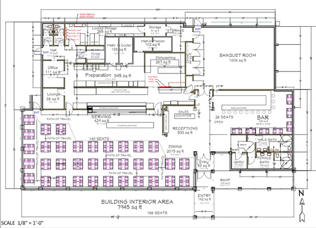
Restaurantbuilding
YOLO
CH
California
B and X Area of moderate flood hazard, usually the area between the limits of the 100-year and 500-year floods.
5.07 AC
2024
Outer Yolo County
2025
Sacramento
011400
Sacramento-Roseville-Folsom, CA
7,832 SF
NEARBY LISTINGS FOR SALE OR LEASE
DEMOGRAPHICS near 4070 County Road 89 Rd
1 mile
3 mile
5 mile
2025 Total Population
11
58
118
2030 Population
11
57
114
Pop Growth 2025-2030
0.00%
(1.72%)
(3.39%)
Average Age
40
42
41
2025 Total Households
4
20
40
HH Growth 2025-2030
0.00%
0.00%
(2.50%)
Median Household Inc
$175,000
$67,500
$79,687
Avg Household Size
2.50
2.90
2.90
2025 Avg HH Vehicles
2.00
2.00
2.00
Median Home Value
$874,999
$600,000
$600,000
Median Year Built
1984
1981
1968
Nearby Places
Map Layers
Map Styles
 Street
 Aerial
Layers
 Traffic
 Biking
Places
Listings with unknown addresses are not visible on the map
- Restaurants
- Banks
- Shops
- Fitness
- Groceries
PUBLIC TRANSPORTATION
AIRPORT
Sacramento International
Drive
Walk
Distance
Sacramento International
36 min
29.8 mi
Freight Ports
Port of Richmond
Drive
Walk
Distance
Port of Richmond
98 min
82.0 mi
SALE & LEASE HISTORY
LISTING DATE
SALE/LEASE

Feb 26, 2020
For Sale
Nearby Properties
Address
Land Use
TOTAL SIZE
Lot Size
Zoning
Address
Land Use
TOTAL SIZE
Lot Size
Zoning
140.89 AC
A-1
Address
Land Use
TOTAL SIZE
Lot Size
Zoning
2,797 SF
90.39 AC
CH
Address
Land Use
TOTAL SIZE
Lot Size
Zoning
11,591 SF
15.87 AC
CH
Address
Land Use
TOTAL SIZE
Lot Size
Zoning
39.30 AC
A1
Address
Land Use
TOTAL SIZE
Lot Size
Zoning
236.04 AC
A1
Address
Land Use
TOTAL SIZE
Lot Size
Zoning
651.90 AC
AP
Address
Land Use
TOTAL SIZE
Lot Size
Zoning
646.19 AC
AP
Address
Land Use
TOTAL SIZE
Lot Size
Zoning
2,168 SF
169.13 AC
A1
Address
Land Use
TOTAL SIZE
Lot Size
Zoning
4,990 SF
6.76 AC
CH
Address
Land Use
TOTAL SIZE
Lot Size
Zoning
77.33 AC
A1
Address
Land Use
TOTAL SIZE
Lot Size
Zoning
135.07 AC
A1
Address
Land Use
TOTAL SIZE
Lot Size
Zoning
1,344 SF
4.23 AC
CH
Address
Land Use
TOTAL SIZE
Lot Size
Zoning
100 AC
A1
Address
Land Use
TOTAL SIZE
Lot Size
Zoning
4,522 SF
1.52 AC
CH
Address
Land Use
TOTAL SIZE
Lot Size
Zoning
300.38 AC
AP
Address
Land Use
TOTAL SIZE
Lot Size
Zoning
281.28 AC
A1
Address
Land Use
TOTAL SIZE
Lot Size
Zoning
5,679 SF
2.31 AC
CH
Address
Land Use
TOTAL SIZE
Lot Size
Zoning
3,042 SF
53.73 AC
A1
Address
Land Use
TOTAL SIZE
Lot Size
Zoning
Address
Land Use
TOTAL SIZE
Lot Size
Zoning
85.44 AC
A-P
Address
Land Use
TOTAL SIZE
Lot Size
Zoning
2,530 SF
0.58 AC
CH
Address
Land Use
TOTAL SIZE
Lot Size
Zoning
1,558 SF
146.79 AC
AP
Address
Land Use
TOTAL SIZE
Lot Size
Zoning
2,584 SF
0.55 AC
CH
Address
Land Use
TOTAL SIZE
Lot Size
Zoning
3,780 SF
0.44 AC
CH
Address
Land Use
TOTAL SIZE
Lot Size
Zoning
2,502 SF
160 AC
AP
Address
Land Use
TOTAL SIZE
Lot Size
Zoning
55.44 AC
AP
Address
Land Use
TOTAL SIZE
Lot Size
Zoning
0.19 AC
CH
Address
Land Use
TOTAL SIZE
Lot Size
Zoning
0.17 AC
CH
Address
Land Use
TOTAL SIZE
Lot Size
Zoning
251.91 AC
AP
Address
Land Use
TOTAL SIZE
Lot Size
Zoning
1,227 SF
311.57 AC
AP
The World's #1 Commercial Real Estate Marketplace
Connect with us
© 2026 CoStar Group
The information above has been obtained from sources believed reliable. While we do not doubt its accuracy we have not verified it and make no guarantee, warranty or representation about it. It is your responsibility to independently confirm its accuracy and completeness. Any projections, opinions, assumptions, or estimates used are for example only and do not represent the current or future performance of the property. The value of this transaction to you depends on tax and other factors which should be evaluated by your tax, financial, and legal advisors. You and your advisors should conduct a careful, independent investigation of the property to determine to your satisfaction the suitability of the property for your needs.