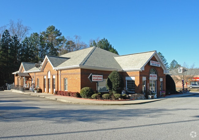
Property Record
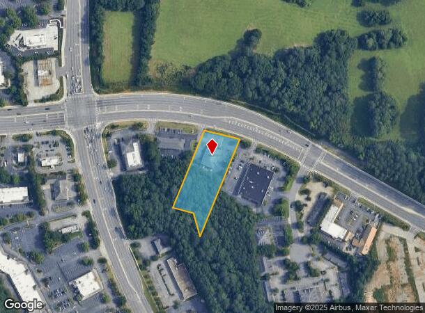
4075 Pleasant Hill Rd, Duluth, GA 30096
Property Detail
4075 Pleasant Hill Rd
Atlanta-Sandy Springs-Roswell, GA
Howell Station
6-296-085
L10 HOWELL STATION
Animalhospitalvet
Gwinnett
AE
Georgia
13121C0093G
10
2025
1.62 AC
2025
Duluth/Suwanee/Buford
050205
Atlanta
5,560 SF
NEARBY LISTINGS FOR SALE OR LEASE
DEMOGRAPHICS near 4075 Pleasant Hill Rd
1 mile
3 mile
5 mile
2024 Total Population
11,826
67,386
198,421
2029 Population
12,407
70,006
205,987
Pop Growth 2024-2029
+ 4.91%
+ 3.89%
+ 3.81%
Average Age
39
40
39
2024 Total Households
4,918
24,796
71,691
HH Growth 2024-2029
+ 5.06%
+ 4.00%
+ 3.88%
Median Household Inc
$69,760
$94,559
$89,318
Avg Household Size
2.40
2.70
2.70
2024 Avg HH Vehicles
2.00
2.00
2.00
Median Home Value
$304,462
$397,767
$417,511
Median Year Built
1990
1993
1994
Nearby Places
Map Layers
Map Styles
 Street
 Aerial
Transit
 Traffic
 Biking
Places
Listings with unknown addresses are not visible on the map
- Restaurants
- Banks
- Shops
- Fitness
- Groceries
PUBLIC TRANSPORTATION
AIRPORT
Hartsfield - Jackson Atlanta International
Drive
Walk
Distance
Hartsfield - Jackson Atlanta International
50 min
35.9 mi
Nearby Properties
Address
Land Use
TOTAL SIZE
Lot Size
Zoning
Address
Land Use
TOTAL SIZE
Lot Size
Zoning
794,057 SF
78.64 AC
PUD
Address
Land Use
TOTAL SIZE
Lot Size
Zoning
508,494 SF
38.74 AC
RM13
Address
Land Use
TOTAL SIZE
Lot Size
Zoning
356,984 SF
24.89 AC
PUD
Address
Land Use
TOTAL SIZE
Lot Size
Zoning
346,219 SF
21.95 AC
PUD
Address
Land Use
TOTAL SIZE
Lot Size
Zoning
523,344 SF
40.47 AC
RM
Address
Land Use
TOTAL SIZE
Lot Size
Zoning
423,004 SF
47.93 AC
RM
Address
Land Use
TOTAL SIZE
Lot Size
Zoning
491,482 SF
41.72 AC
C1
Address
Land Use
TOTAL SIZE
Lot Size
Zoning
620,975 SF
8.10 AC
PUD
Address
Land Use
TOTAL SIZE
Lot Size
Zoning
341,506 SF
36.69 AC
C1
Address
Land Use
TOTAL SIZE
Lot Size
Zoning
329,029 SF
21.16 AC
C1
Address
Land Use
TOTAL SIZE
Lot Size
Zoning
372,904 SF
11.64 AC
PUD
Address
Land Use
TOTAL SIZE
Lot Size
Zoning
609,495 SF
6.28 AC
PUD
Address
Land Use
TOTAL SIZE
Lot Size
Zoning
418,495 SF
22.06 AC
PUD
Address
Land Use
TOTAL SIZE
Lot Size
Zoning
88.90 AC
AG1
Address
Land Use
TOTAL SIZE
Lot Size
Zoning
287,824 SF
31.59 AC
RM
Address
Land Use
TOTAL SIZE
Lot Size
Zoning
217,080 SF
49.32 AC
M1
Address
Land Use
TOTAL SIZE
Lot Size
Zoning
263,285 SF
22.50 AC
RM
Address
Land Use
TOTAL SIZE
Lot Size
Zoning
252,043 SF
22.03 AC
RM
Address
Land Use
TOTAL SIZE
Lot Size
Zoning
256,640 SF
28.59 AC
RM
Address
Land Use
TOTAL SIZE
Lot Size
Zoning
1,052,800 SF
51.40 AC
M2
Address
Land Use
TOTAL SIZE
Lot Size
Zoning
326,904 SF
46.73 AC
OI
Address
Land Use
TOTAL SIZE
Lot Size
Zoning
304,001 SF
32 AC
PUD
Address
Land Use
TOTAL SIZE
Lot Size
Zoning
1,650 SF
74.37 AC
AG1
Address
Land Use
TOTAL SIZE
Lot Size
Zoning
235,586 SF
16.21 AC
PUD
Address
Land Use
TOTAL SIZE
Lot Size
Zoning
197,115 SF
16.93 AC
PUD
Address
Land Use
TOTAL SIZE
Lot Size
Zoning
180,572 SF
14.77 AC
C1
Address
Land Use
TOTAL SIZE
Lot Size
Zoning
212,250 SF
150 AC
AG1
Address
Land Use
TOTAL SIZE
Lot Size
Zoning
43.34 AC
R4A
Address
Land Use
TOTAL SIZE
Lot Size
Zoning
315,667 SF
13.49 AC
M2
Address
Land Use
TOTAL SIZE
Lot Size
Zoning
164,551 SF
21.10 AC
C1
The World's #1 Commercial Real Estate Marketplace
Connect with us
© 2026 CoStar Group
The information above has been obtained from sources believed reliable. While we do not doubt its accuracy we have not verified it and make no guarantee, warranty or representation about it. It is your responsibility to independently confirm its accuracy and completeness. Any projections, opinions, assumptions, or estimates used are for example only and do not represent the current or future performance of the property. The value of this transaction to you depends on tax and other factors which should be evaluated by your tax, financial, and legal advisors. You and your advisors should conduct a careful, independent investigation of the property to determine to your satisfaction the suitability of the property for your needs.