Property Record
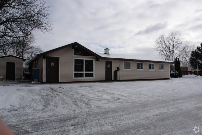
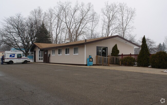
4077 Holt Rd, Holt, MI 48842
Property Detail
4077 Holt Rd
25-05-23-226-002
(D 23-8-2, 23-8-3, 23-8-4) BEG AT NW COR OF SE 1/4 OF NE 1/4 OF SEC 23, TH E 1136.7 FT ALG N LN OF SE 1/4 OF NE 1/4 TO E BANK
Miscresidentialimprovement
INGHAM
RM-1
Michigan
A Areas with a 1% annual chance of flooding and a 26% chance of flooding over the life of a 30-year mortgage.
20.73 AC
2024
Outer Ingham County
2025
West Michigan
005402
Lansing-East Lansing, MI
1,708 SF
NEARBY LISTINGS FOR SALE OR LEASE
-
-
View all Holt listings for sale on LoopNet.com
DEMOGRAPHICS near 4077 Holt Rd
1 mile
3 mile
5 mile
2025 Total Population
6,377
26,746
69,808
2030 Population
6,375
26,934
70,492
Pop Growth 2025-2030
(0.03%)
+ 0.70%
+ 0.98%
Average Age
40
40
39
2025 Total Households
2,759
11,446
29,383
HH Growth 2025-2030
+ 0.25%
+ 0.79%
+ 1.06%
Median Household Inc
$75,325
$75,053
$68,353
Avg Household Size
2.30
2.30
2.30
2025 Avg HH Vehicles
2.00
2.00
2.00
Median Home Value
$186,221
$201,006
$177,813
Median Year Built
1977
1977
1975
Nearby Places
Map Layers
Map Styles
 Street
 Aerial
Layers
 Traffic
 Biking
Places
Listings with unknown addresses are not visible on the map
- Restaurants
- Banks
- Shops
- Fitness
- Groceries
PUBLIC TRANSPORTATION
COMMUTER RAIL
Drive
Walk
Distance
14 min
8.6 mi
AIRPORT
Capital Region International
Drive
Walk
Distance
Capital Region International
23 min
12.0 mi
Nearby Properties
Address
Land Use
TOTAL SIZE
Lot Size
Zoning
Address
Land Use
TOTAL SIZE
Lot Size
Zoning
21,447 SF
56.20 AC
RM
Address
Land Use
TOTAL SIZE
Lot Size
Zoning
178,096 SF
22.80 AC
IP
Address
Land Use
TOTAL SIZE
Lot Size
Zoning
269,915 SF
Address
Land Use
TOTAL SIZE
Lot Size
Zoning
410 AC
Address
Land Use
TOTAL SIZE
Lot Size
Zoning
912 SF
20.97 AC
RM
Address
Land Use
TOTAL SIZE
Lot Size
Zoning
7,868 SF
12.03 AC
RM
Address
Land Use
TOTAL SIZE
Lot Size
Zoning
8,341 SF
27.70 AC
RM
Address
Land Use
TOTAL SIZE
Lot Size
Zoning
616,146 SF
111.68 AC
IP
Address
Land Use
TOTAL SIZE
Lot Size
Zoning
17,920 SF
208 AC
Address
Land Use
TOTAL SIZE
Lot Size
Zoning
351 SF
20.90 AC
Address
Land Use
TOTAL SIZE
Lot Size
Zoning
1,642 SF
288 AC
DM-1 RE
Address
Land Use
TOTAL SIZE
Lot Size
Zoning
10,112 SF
12.57 AC
RM-1
Address
Land Use
TOTAL SIZE
Lot Size
Zoning
47,352 SF
2.41 AC
TC
Address
Land Use
TOTAL SIZE
Lot Size
Zoning
14,981 SF
12.66 AC
R-1E
Address
Land Use
TOTAL SIZE
Lot Size
Zoning
75,476 SF
17.70 AC
Address
Land Use
TOTAL SIZE
Lot Size
Zoning
168,480 SF
15.30 AC
G-2 WHO
Address
Land Use
TOTAL SIZE
Lot Size
Zoning
3,528 SF
230 AC
Address
Land Use
TOTAL SIZE
Lot Size
Zoning
80,080 SF
7.91 AC
D-1 PRO
Address
Land Use
TOTAL SIZE
Lot Size
Zoning
Address
Land Use
TOTAL SIZE
Lot Size
Zoning
16,913 SF
11.25 AC
R-1E
Address
Land Use
TOTAL SIZE
Lot Size
Zoning
15,439 SF
13.13 AC
R-1E
Address
Land Use
TOTAL SIZE
Lot Size
Zoning
26,042 SF
3.58 AC
C-2
Address
Land Use
TOTAL SIZE
Lot Size
Zoning
20,834 SF
11.85 AC
F COMM
Address
Land Use
TOTAL SIZE
Lot Size
Zoning
29,965 SF
4.52 AC
A-1
Address
Land Use
TOTAL SIZE
Lot Size
Zoning
138,424 SF
14.80 AC
MIXED Z
Address
Land Use
TOTAL SIZE
Lot Size
Zoning
135,318 SF
10.59 AC
G-2 WHO
Address
Land Use
TOTAL SIZE
Lot Size
Zoning
72,523 SF
6.75 AC
Address
Land Use
TOTAL SIZE
Lot Size
Zoning
88,453 SF
10.94 AC
G-2 WHO
Address
Land Use
TOTAL SIZE
Lot Size
Zoning
26,840 SF
2.59 AC
C-2
Address
Land Use
TOTAL SIZE
Lot Size
Zoning
11,218 SF
2.24 AC
F COMM
The World's #1 Commercial Real Estate Marketplace
Connect with us
© 2026 CoStar Group
The information above has been obtained from sources believed reliable. While we do not doubt its accuracy we have not verified it and make no guarantee, warranty or representation about it. It is your responsibility to independently confirm its accuracy and completeness. Any projections, opinions, assumptions, or estimates used are for example only and do not represent the current or future performance of the property. The value of this transaction to you depends on tax and other factors which should be evaluated by your tax, financial, and legal advisors. You and your advisors should conduct a careful, independent investigation of the property to determine to your satisfaction the suitability of the property for your needs.