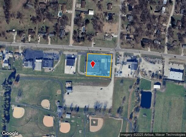
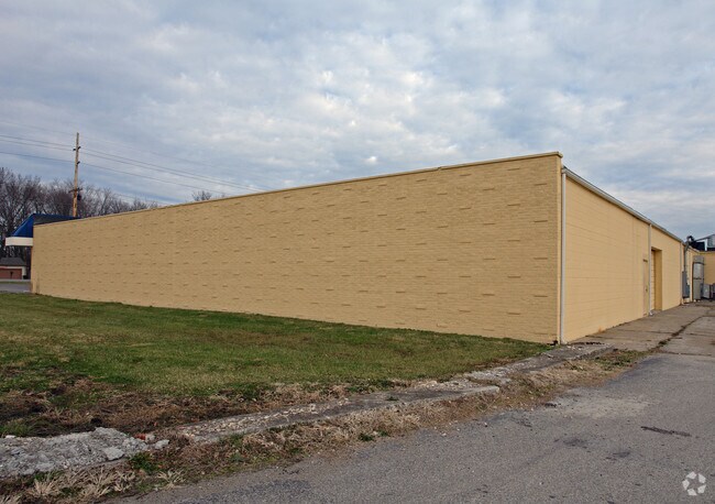
Property Record
4077 W Route 122 Ln, Franklin, OH 45005

NEARBY LISTINGS FOR SALE OR LEASE
Property Detail
4077 W Route 122 Ln
Cincinnati, OH-KY-IN
Wilshire Heights 3
08-27-426-011-1
WILSHIRE HEIGHTS 3 LOT 168
Commercialnec
Warren
X
Ohio
39165C0110F
168
2024
0.71 AC
2024
Outlying Warren County
030600
Cincinnati/Dayton
14,515 SF
DEMOGRAPHICS near 4077 W Route 122 Ln
1 Mile
3 Mile
5 Mile
2024 Total Population
3,525
14,901
66,655
2029 Population
3,861
16,294
71,172
Pop Growth 2024-2029
+ 9.53%
+ 9.35%
+ 6.78%
Average Age
42
42
41
2024 Total Households
1,306
5,826
25,901
HH Growth 2024-2029
+ 9.57%
+ 9.32%
+ 6.99%
Median Household Inc
$95,645
$91,875
$72,019
Avg Household Size
2.60
2.50
2.40
2024 Avg HH Vehicles
2.00
2.00
2.00
Median Home Value
$230,989
$267,699
$207,403
Median Year Built
1988
1997
1979
Nearby Places
Map Layers
Map Styles
 Street
 Aerial
- Restaurants
- Banks
- Shops
- Fitness
- Groceries
PUBLIC TRANSPORTATION
AIRPORT
James M Cox Dayton International
DRIVE
WALK
Distance
James M Cox Dayton International
49 min
36.0 mi
Cincinnati/Northern Kentucky International
DRIVE
WALK
Distance
Cincinnati/Northern Kentucky International
70 min
48.1 mi
SALE & LEASE HISTORY
LISTING DATE
SALE/LEASE

Sep 26, 2016
For Lease
Oct 16, 2024
For Lease
Feb 01, 2017
For Lease
Nearby Properties
Address
Land Use
TOTAL SIZE
Lot Size
Zoning
Address
Land Use
TOTAL SIZE
Lot Size
Zoning
160,701 SF
10.83 AC
Address
Land Use
TOTAL SIZE
Lot Size
Zoning
Address
Land Use
TOTAL SIZE
Lot Size
Zoning
9,224 SF
16.21 AC
Address
Land Use
TOTAL SIZE
Lot Size
Zoning
5,000 SF
60.29 AC
Address
Land Use
TOTAL SIZE
Lot Size
Zoning
9,224 SF
16.21 AC
Address
Land Use
TOTAL SIZE
Lot Size
Zoning
7.18 AC
Address
Land Use
TOTAL SIZE
Lot Size
Zoning
27,780 SF
1.20 AC
Address
Land Use
TOTAL SIZE
Lot Size
Zoning
24,808 SF
3.26 AC
Address
Land Use
TOTAL SIZE
Lot Size
Zoning
2,221 SF
7.84 AC
Address
Land Use
TOTAL SIZE
Lot Size
Zoning
120,685 SF
21.52 AC
Address
Land Use
TOTAL SIZE
Lot Size
Zoning
14,325 SF
1.84 AC
Address
Land Use
TOTAL SIZE
Lot Size
Zoning
37,842 SF
13.68 AC
Address
Land Use
TOTAL SIZE
Lot Size
Zoning
190,295 SF
21.70 AC
Address
Land Use
TOTAL SIZE
Lot Size
Zoning
20,250 SF
3.28 AC
Address
Land Use
TOTAL SIZE
Lot Size
Zoning
109,584 SF
9.77 AC
Address
Land Use
TOTAL SIZE
Lot Size
Zoning
113,241 SF
7.84 AC
Address
Land Use
TOTAL SIZE
Lot Size
Zoning
12,500 SF
32.38 AC
MXUC
Address
Land Use
TOTAL SIZE
Lot Size
Zoning
111,304 SF
19.53 AC
Address
Land Use
TOTAL SIZE
Lot Size
Zoning
64.34 AC
Address
Land Use
TOTAL SIZE
Lot Size
Zoning
14.36 AC
Address
Land Use
TOTAL SIZE
Lot Size
Zoning
58,564 SF
14.72 AC
Address
Land Use
TOTAL SIZE
Lot Size
Zoning
13,145 SF
1.77 AC
Address
Land Use
TOTAL SIZE
Lot Size
Zoning
75,120 SF
6.15 AC
Address
Land Use
TOTAL SIZE
Lot Size
Zoning
25,588 SF
7.36 AC
Address
Land Use
TOTAL SIZE
Lot Size
Zoning
59,038 SF
10 AC
Address
Land Use
TOTAL SIZE
Lot Size
Zoning
13,659 SF
1.52 AC
Address
Land Use
TOTAL SIZE
Lot Size
Zoning
205,346 SF
24 AC
Address
Land Use
TOTAL SIZE
Lot Size
Zoning
6.52 AC
Address
Land Use
TOTAL SIZE
Lot Size
Zoning
15,530 SF
4.50 AC
Address
Land Use
TOTAL SIZE
Lot Size
Zoning
5,370 SF
3.68 AC
The World's #1 Commercial Real Estate Marketplace
Connect with us
© 2025 CoStar Group
The information above has been obtained from sources believed reliable. While we do not doubt its accuracy we have not verified it and make no guarantee, warranty or representation about it. It is your responsibility to independently confirm its accuracy and completeness. Any projections, opinions, assumptions, or estimates used are for example only and do not represent the current or future performance of the property. The value of this transaction to you depends on tax and other factors which should be evaluated by your tax, financial, and legal advisors. You and your advisors should conduct a careful, independent investigation of the property to determine to your satisfaction the suitability of the property for your needs.