Property Record
4079 Deerfield Rd, Eau Claire, WI 54701

Save to a Folder
{{folder.Name}}
{{folder.ListingIds.length}} Properties
{{folder.ListingIds.length}} Property
Create a New Folder
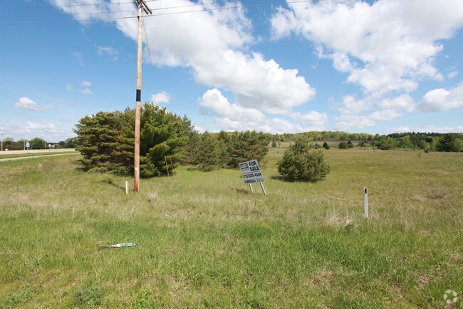
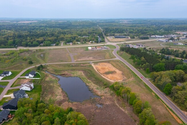
This Property Is For Sale
Property Detail
4079 Deerfield Rd
Eau Claire, WI
LOT 1 CSM 2178 (VOL 12 P 5 #905371)
18024-2-260914-220-9000
EAU CLAIRE
Commercialnec
Wisconsin
C3
1
B and X Area of moderate flood hazard, usually the area between the limits of the 100-year and 500-year floods.
2.24 AC
2025
Eau Claire/Menomonie
2025
Other Market Areas
000302
NEARBY LISTINGS FOR SALE OR LEASE
DEMOGRAPHICS near 4079 Deerfield Rd
1 mile
3 mile
5 mile
2025 Total Population
893
14,925
49,084
2030 Population
933
15,419
50,595
Pop Growth 2025-2030
+ 4.48%
+ 3.31%
+ 3.08%
Average Age
41
41
39
2025 Total Households
332
6,458
19,695
HH Growth 2025-2030
+ 4.52%
+ 3.34%
+ 3.27%
Median Household Inc
$134,285
$76,558
$79,028
Avg Household Size
2.60
2.30
2.30
2025 Avg HH Vehicles
3.00
2.00
2.00
Median Home Value
$382,257
$340,714
$291,022
Median Year Built
1986
1993
1985
Nearby Places
Map Layers
Map Styles
 Street
 Aerial
Layers
 Traffic
 Biking
Places
Listings with unknown addresses are not visible on the map
- Restaurants
- Banks
- Shops
- Fitness
- Groceries
Nearby Properties
Address
Land Use
TOTAL SIZE
Lot Size
Zoning
Address
Land Use
TOTAL SIZE
Lot Size
Zoning
520,119 SF
42.39 AC
C3
Address
Land Use
TOTAL SIZE
Lot Size
Zoning
207,978 SF
24.47 AC
C3P
Address
Land Use
TOTAL SIZE
Lot Size
Zoning
132,943 SF
11.26 AC
Address
Land Use
TOTAL SIZE
Lot Size
Zoning
66,393 SF
12.95 AC
Address
Land Use
TOTAL SIZE
Lot Size
Zoning
200,880 SF
14.86 AC
C3P
Address
Land Use
TOTAL SIZE
Lot Size
Zoning
173,473 SF
14.38 AC
C3P
Address
Land Use
TOTAL SIZE
Lot Size
Zoning
96,149 SF
5.92 AC
R3P
Address
Land Use
TOTAL SIZE
Lot Size
Zoning
169,740 SF
13.16 AC
C3P
Address
Land Use
TOTAL SIZE
Lot Size
Zoning
92,178 SF
3.81 AC
C3P
Address
Land Use
TOTAL SIZE
Lot Size
Zoning
50,979 SF
10.40 AC
C3P
Address
Land Use
TOTAL SIZE
Lot Size
Zoning
39,120 SF
5.03 AC
Address
Land Use
TOTAL SIZE
Lot Size
Zoning
Address
Land Use
TOTAL SIZE
Lot Size
Zoning
62,964 SF
2.50 AC
R3P
Address
Land Use
TOTAL SIZE
Lot Size
Zoning
117,095 SF
18.74 AC
C3P
Address
Land Use
TOTAL SIZE
Lot Size
Zoning
3.37 AC
Address
Land Use
TOTAL SIZE
Lot Size
Zoning
8,938 SF
8.06 AC
Address
Land Use
TOTAL SIZE
Lot Size
Zoning
107,347 SF
6.04 AC
C3
Address
Land Use
TOTAL SIZE
Lot Size
Zoning
Address
Land Use
TOTAL SIZE
Lot Size
Zoning
50,001 SF
6.61 AC
C3P
Address
Land Use
TOTAL SIZE
Lot Size
Zoning
44,559 SF
2.07 AC
C3
Address
Land Use
TOTAL SIZE
Lot Size
Zoning
42,670 SF
4.11 AC
C3P
Address
Land Use
TOTAL SIZE
Lot Size
Zoning
80,286 SF
9.75 AC
C3P
Address
Land Use
TOTAL SIZE
Lot Size
Zoning
98,104 SF
6.79 AC
Address
Land Use
TOTAL SIZE
Lot Size
Zoning
36,916 SF
1.40 AC
C2P
Address
Land Use
TOTAL SIZE
Lot Size
Zoning
29,933 SF
2.84 AC
C3
Address
Land Use
TOTAL SIZE
Lot Size
Zoning
41,970 SF
9.32 AC
C3P
Address
Land Use
TOTAL SIZE
Lot Size
Zoning
44,567 SF
2.57 AC
C3P
Address
Land Use
TOTAL SIZE
Lot Size
Zoning
1.37 AC
C3P
Address
Land Use
TOTAL SIZE
Lot Size
Zoning
105,255 SF
8.19 AC
C3
Address
Land Use
TOTAL SIZE
Lot Size
Zoning
97,719 SF
9.27 AC
C3
The World's #1 Commercial Real Estate Marketplace
Connect with us
© 2026 CoStar Group
The information above has been obtained from sources believed reliable. While we do not doubt its accuracy we have not verified it and make no guarantee, warranty or representation about it. It is your responsibility to independently confirm its accuracy and completeness. Any projections, opinions, assumptions, or estimates used are for example only and do not represent the current or future performance of the property. The value of this transaction to you depends on tax and other factors which should be evaluated by your tax, financial, and legal advisors. You and your advisors should conduct a careful, independent investigation of the property to determine to your satisfaction the suitability of the property for your needs.