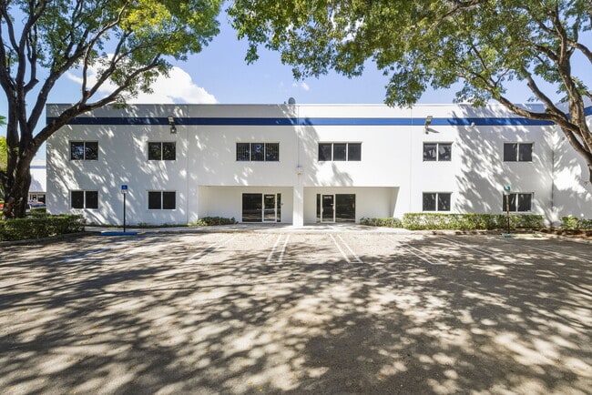
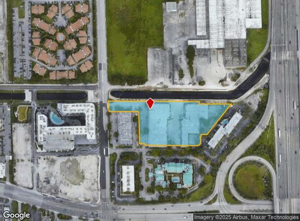
Property Record
4055 Nw 79Th Ave, Doral, FL 33166
Current Lease Availabilities
NEARBY LISTINGS FOR SALE OR LEASE
Property Detail
4055 Nw 79Th Ave
35-3027-032-0010
Fairfield Inn Sub
Warehouse
FAIRFIELD INN SUB PB 136-17 TR A LESS W215FT & LESS N75FT & LESS E40FT OF W255FT OF S10FT LOT SIZE 194158 SQ FT OR 17069-0972 0196 4 (2) F/A/U 30-3027-032-0010
AH
Miami/Dade
12086C0287L
Florida
2024
4.46 AC
2025
Miami Airport West
009065
South Florida
84,783 SF
Miami-Miami Beach-Kendall, FL
DEMOGRAPHICS near 4055 Nw 79Th Ave
1 Mile
3 Mile
5 Mile
2024 Total Population
15,586
104,538
444,816
2029 Population
16,476
103,662
432,577
Pop Growth 2024-2029
+ 5.71%
(0.84%)
(2.75%)
Average Age
35
41
43
2024 Total Households
5,925
38,301
151,248
HH Growth 2024-2029
+ 5.06%
(1.30%)
(3.17%)
Median Household Inc
$68,134
$54,676
$53,070
Avg Household Size
2.60
2.60
2.80
2024 Avg HH Vehicles
1.00
2.00
2.00
Median Home Value
$550,138
$362,697
$354,050
Median Year Built
2011
1984
1977
Nearby Places
Map Layers
Map Styles
 Street
 Aerial
- Restaurants
- Banks
- Shops
- Fitness
- Groceries
PUBLIC TRANSPORTATION
COMMUTER RAIL
Palmetto (Metrorail Green Line - Miami-Dade Transit (Metrorail/Metromover))
DRIVE
WALK
Distance
Palmetto (Metrorail Green Line - Miami-Dade Transit (Metrorail/Metromover))
7 min
3.0 mi
Okeechobee (Metrorail Green Line - Miami-Dade Transit (Metrorail/Metromover))
DRIVE
WALK
Distance
Okeechobee (Metrorail Green Line - Miami-Dade Transit (Metrorail/Metromover))
8 min
3.9 mi
AIRPORT
Miami International
DRIVE
WALK
Distance
Miami International
10 min
3.6 mi
Fort Lauderdale/Hollywood International
DRIVE
WALK
Distance
Fort Lauderdale/Hollywood International
41 min
27.9 mi
Freight Ports
Port of Miami
DRIVE
WALK
Distance
Port of Miami
23 min
13.1 mi
Nearby Properties
Address
Land Use
TOTAL SIZE
Lot Size
Zoning
Address
Land Use
TOTAL SIZE
Lot Size
Zoning
1,071,874 SF
6.73 AC
4802
Address
Land Use
TOTAL SIZE
Lot Size
Zoning
312,996 SF
157.16 AC
8900
Address
Land Use
TOTAL SIZE
Lot Size
Zoning
851,502 SF
11.73 AC
6119
Address
Land Use
TOTAL SIZE
Lot Size
Zoning
1,680,493 SF
23.71 AC
4100
Address
Land Use
TOTAL SIZE
Lot Size
Zoning
481,242 SF
13.61 AC
6400
Address
Land Use
TOTAL SIZE
Lot Size
Zoning
465,663 SF
11.29 AC
4100
Address
Land Use
TOTAL SIZE
Lot Size
Zoning
666,015 SF
4 AC
6119
Address
Land Use
TOTAL SIZE
Lot Size
Zoning
582,921 SF
4.51 AC
6119
Address
Land Use
TOTAL SIZE
Lot Size
Zoning
929,765 SF
453.69 AC
6119
Address
Land Use
TOTAL SIZE
Lot Size
Zoning
418,532 SF
17.95 AC
7300
Address
Land Use
TOTAL SIZE
Lot Size
Zoning
328,554 SF
668.26 AC
8900
Address
Land Use
TOTAL SIZE
Lot Size
Zoning
608,139 SF
5.80 AC
6119
Address
Land Use
TOTAL SIZE
Lot Size
Zoning
884,102 SF
28.46 AC
7300
Address
Land Use
TOTAL SIZE
Lot Size
Zoning
612,289 SF
3.38 AC
6119
Address
Land Use
TOTAL SIZE
Lot Size
Zoning
1,700 SF
7.24 AC
7100
Address
Land Use
TOTAL SIZE
Lot Size
Zoning
755,156 SF
29.44 AC
7100
Address
Land Use
TOTAL SIZE
Lot Size
Zoning
429,568 SF
7.44 AC
6400
Address
Land Use
TOTAL SIZE
Lot Size
Zoning
352,663 SF
0.65 AC
6119
Address
Land Use
TOTAL SIZE
Lot Size
Zoning
438,387 SF
16.20 AC
3900
Address
Land Use
TOTAL SIZE
Lot Size
Zoning
453,404 SF
469.53 AC
7300
Address
Land Use
TOTAL SIZE
Lot Size
Zoning
359,107 SF
9.58 AC
9450
Address
Land Use
TOTAL SIZE
Lot Size
Zoning
428,212 SF
17.56 AC
3900
Address
Land Use
TOTAL SIZE
Lot Size
Zoning
344,465 SF
5.03 AC
6400
Address
Land Use
TOTAL SIZE
Lot Size
Zoning
468,218 SF
17.06 AC
7100
Address
Land Use
TOTAL SIZE
Lot Size
Zoning
344,101 SF
0.74 AC
6119
Address
Land Use
TOTAL SIZE
Lot Size
Zoning
366,237 SF
9.24 AC
4100
Address
Land Use
TOTAL SIZE
Lot Size
Zoning
687,304 SF
3.03 AC
6119
Address
Land Use
TOTAL SIZE
Lot Size
Zoning
648,867 SF
33.08 AC
7100
Address
Land Use
TOTAL SIZE
Lot Size
Zoning
527,157 SF
4.15 AC
6119
Address
Land Use
TOTAL SIZE
Lot Size
Zoning
538,739 SF
5.05 AC
7100
The World's #1 Commercial Real Estate Marketplace
Connect with us
© 2025 CoStar Group
The information above has been obtained from sources believed reliable. While we do not doubt its accuracy we have not verified it and make no guarantee, warranty or representation about it. It is your responsibility to independently confirm its accuracy and completeness. Any projections, opinions, assumptions, or estimates used are for example only and do not represent the current or future performance of the property. The value of this transaction to you depends on tax and other factors which should be evaluated by your tax, financial, and legal advisors. You and your advisors should conduct a careful, independent investigation of the property to determine to your satisfaction the suitability of the property for your needs.