Property Record
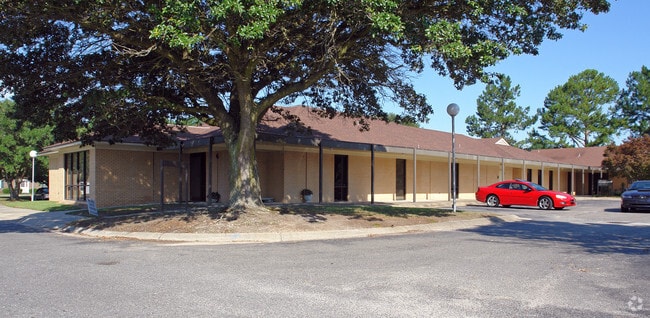
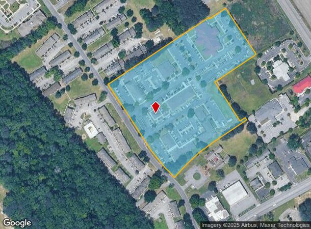
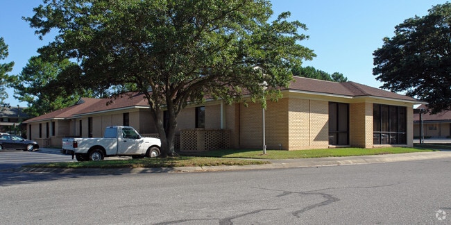
701 Doctors Dr, Kinston, NC 28501

NEARBY LISTINGS FOR SALE OR LEASE
Property Detail
701 Doctors Dr
452609157203
Survey For State Employees Credit Union
Medicalbuilding
KINSTON CLINIC NORTH TLVA / 78,665SF
X
Lenoir
3720452600K
North Carolina
2025
159.12 AC
2025
North Carolina Southeast Area
010600
Other Market Areas
18,213 SF
Kinston, NC
DEMOGRAPHICS near 701 Doctors Dr
1 Mile
3 Mile
5 Mile
2024 Total Population
3,728
20,320
27,759
2029 Population
3,643
20,326
27,620
Pop Growth 2024-2029
(2.28%)
+ 0.03%
(0.50%)
Average Age
45
43
43
2024 Total Households
1,570
8,805
11,884
HH Growth 2024-2029
(2.36%)
+ 0.08%
(0.48%)
Median Household Inc
$46,066
$32,793
$36,791
Avg Household Size
2.20
2.20
2.20
2024 Avg HH Vehicles
2.00
1.00
2.00
Median Home Value
$141,666
$97,932
$97,179
Median Year Built
1971
1967
1971
Nearby Places
- Restaurants
- Banks
- Shops
- Fitness
- Groceries
PUBLIC TRANSPORTATION
AIRPORT
Pitt-Greenville
DRIVE
WALK
Distance
Pitt-Greenville
45 min
34.4 mi
Freight Ports
Port of Morehead City
DRIVE
WALK
Distance
Port of Morehead City
116 min
79.1 mi
Nearby Properties
Address
Land Use
TOTAL SIZE
Lot Size
Zoning
Address
Land Use
TOTAL SIZE
Lot Size
Zoning
274,824 SF
54.92 AC
OI
Address
Land Use
TOTAL SIZE
Lot Size
Zoning
22,420 SF
762.37 AC
RA6
Address
Land Use
TOTAL SIZE
Lot Size
Zoning
25,376 SF
953.68 AC
RA12
Address
Land Use
TOTAL SIZE
Lot Size
Zoning
159,064 SF
Address
Land Use
TOTAL SIZE
Lot Size
Zoning
65,704 SF
278.06 AC
RA20
Address
Land Use
TOTAL SIZE
Lot Size
Zoning
114,876 SF
64.24 AC
RA6
Address
Land Use
TOTAL SIZE
Lot Size
Zoning
150,941 SF
20 AC
I1
Address
Land Use
TOTAL SIZE
Lot Size
Zoning
107,460 SF
17.70 AC
I2
Address
Land Use
TOTAL SIZE
Lot Size
Zoning
191,518 SF
20.71 AC
SC
Address
Land Use
TOTAL SIZE
Lot Size
Zoning
15,858 SF
54.75 AC
I1
Address
Land Use
TOTAL SIZE
Lot Size
Zoning
144,099 SF
23.48 AC
RA8
Address
Land Use
TOTAL SIZE
Lot Size
Zoning
214,740 SF
Address
Land Use
TOTAL SIZE
Lot Size
Zoning
156,784 SF
63.12 AC
I1
Address
Land Use
TOTAL SIZE
Lot Size
Zoning
278,576 SF
30.06 AC
I1
Address
Land Use
TOTAL SIZE
Lot Size
Zoning
254,440 SF
51.94 AC
I1
Address
Land Use
TOTAL SIZE
Lot Size
Zoning
145,364 SF
76.38 AC
I1
Address
Land Use
TOTAL SIZE
Lot Size
Zoning
77,100 SF
1.91 AC
B2
Address
Land Use
TOTAL SIZE
Lot Size
Zoning
119,634 SF
1.86 AC
B2
Address
Land Use
TOTAL SIZE
Lot Size
Zoning
51,934 SF
0.32 AC
B2
Address
Land Use
TOTAL SIZE
Lot Size
Zoning
5,664 SF
407.13 AC
RA6
Address
Land Use
TOTAL SIZE
Lot Size
Zoning
28,034 SF
278.73 AC
RA12
Address
Land Use
TOTAL SIZE
Lot Size
Zoning
101,200 SF
30.89 AC
Address
Land Use
TOTAL SIZE
Lot Size
Zoning
117,120 SF
8.12 AC
I1
Address
Land Use
TOTAL SIZE
Lot Size
Zoning
53,768 SF
33.29 AC
I1
Address
Land Use
TOTAL SIZE
Lot Size
Zoning
123,220 SF
8.99 AC
I1
Address
Land Use
TOTAL SIZE
Lot Size
Zoning
23,086 SF
7.39 AC
RA5
Address
Land Use
TOTAL SIZE
Lot Size
Zoning
424,443 SF
104.04 AC
SC
Address
Land Use
TOTAL SIZE
Lot Size
Zoning
44,800 SF
9.75 AC
O&I
Address
Land Use
TOTAL SIZE
Lot Size
Zoning
6,178 SF
6.33 AC
RA5
The World's #1 Commercial Real Estate Marketplace
Connect with us
© 2025 CoStar Group
The information above has been obtained from sources believed reliable. While we do not doubt its accuracy we have not verified it and make no guarantee, warranty or representation about it. It is your responsibility to independently confirm its accuracy and completeness. Any projections, opinions, assumptions, or estimates used are for example only and do not represent the current or future performance of the property. The value of this transaction to you depends on tax and other factors which should be evaluated by your tax, financial, and legal advisors. You and your advisors should conduct a careful, independent investigation of the property to determine to your satisfaction the suitability of the property for your needs.