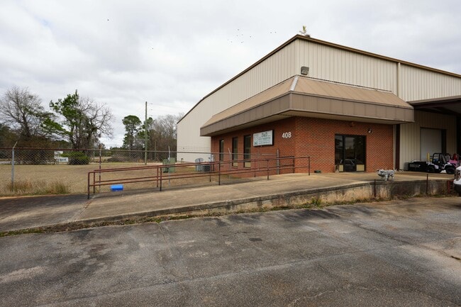
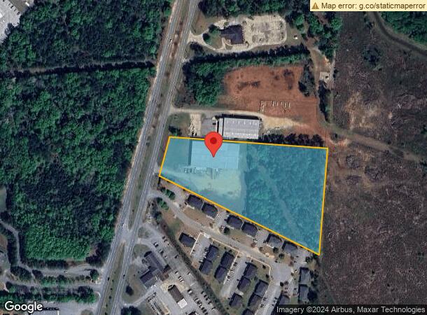
Property Record
408 S Westover Blvd, Albany, GA 31707

NEARBY LISTINGS FOR SALE OR LEASE
Property Detail
408 S Westover Blvd
Albany, GA
Oakhaven Dr
00306-00002-004
TRCT 4 GOODYEAR COMMERCIAL PK
Distributionwarehouseregional
Dougherty
X
Georgia
13095C0105E
119
2025
6.18 AC
2024
Albany/Southwest
001000
Other Market Areas
21,000 SF
DEMOGRAPHICS near 408 S Westover Blvd
1 Mile
3 Mile
5 Mile
2024 Total Population
1,362
27,403
57,767
2029 Population
1,276
25,921
55,448
Pop Growth 2024-2029
(6.31%)
(5.41%)
(4.01%)
Average Age
38
39
40
2024 Total Households
550
11,591
24,636
HH Growth 2024-2029
(6.36%)
(5.50%)
(4.15%)
Median Household Inc
$41,682
$49,455
$49,452
Avg Household Size
2.30
2.30
2.30
2024 Avg HH Vehicles
2.00
2.00
2.00
Median Home Value
$120,869
$145,682
$149,877
Median Year Built
1977
1976
1976
Nearby Places
Map Layers
Map Styles
 Street
 Aerial
- Restaurants
- Banks
- Shops
- Fitness
- Groceries
PUBLIC TRANSPORTATION
AIRPORT
Southwest Georgia Regional
DRIVE
WALK
Distance
Southwest Georgia Regional
9 min
4.4 mi
Freight Ports
Port of Panama City
DRIVE
WALK
Distance
Port of Panama City
228 min
157.5 mi
SALE & LEASE HISTORY
LISTING DATE
SALE/LEASE

Feb 01, 2024
For Sale
Nearby Properties
Address
Land Use
TOTAL SIZE
Lot Size
Zoning
Address
Land Use
TOTAL SIZE
Lot Size
Zoning
126,650 SF
19.41 AC
C2
Address
Land Use
TOTAL SIZE
Lot Size
Zoning
42,880 SF
31.25 AC
R6
Address
Land Use
TOTAL SIZE
Lot Size
Zoning
186,956 SF
29.23 AC
R6
Address
Land Use
TOTAL SIZE
Lot Size
Zoning
232,840 SF
49.88 AC
M1
Address
Land Use
TOTAL SIZE
Lot Size
Zoning
88,144 SF
12.47 AC
C2
Address
Land Use
TOTAL SIZE
Lot Size
Zoning
11,488 SF
12.23 AC
R6
Address
Land Use
TOTAL SIZE
Lot Size
Zoning
9,676 SF
10.73 AC
R6
Address
Land Use
TOTAL SIZE
Lot Size
Zoning
9.37 AC
C3
Address
Land Use
TOTAL SIZE
Lot Size
Zoning
21,760 SF
10.76 AC
R6
Address
Land Use
TOTAL SIZE
Lot Size
Zoning
21,144 SF
11.79 AC
R6
Address
Land Use
TOTAL SIZE
Lot Size
Zoning
35,650 SF
3.73 AC
C5
Address
Land Use
TOTAL SIZE
Lot Size
Zoning
44,671 SF
4 AC
C2
Address
Land Use
TOTAL SIZE
Lot Size
Zoning
51,552 SF
13.26 AC
R6
Address
Land Use
TOTAL SIZE
Lot Size
Zoning
5,768 SF
16.40 AC
R6
Address
Land Use
TOTAL SIZE
Lot Size
Zoning
32,000 SF
14.19 AC
R1A
Address
Land Use
TOTAL SIZE
Lot Size
Zoning
19,104 SF
10.81 AC
R6
Address
Land Use
TOTAL SIZE
Lot Size
Zoning
204,625 SF
27.28 AC
M1
Address
Land Use
TOTAL SIZE
Lot Size
Zoning
126,650 SF
0.96 AC
C2
Address
Land Use
TOTAL SIZE
Lot Size
Zoning
100,392 SF
11.25 AC
C3
Address
Land Use
TOTAL SIZE
Lot Size
Zoning
30,190 SF
212.69 AC
C5
Address
Land Use
TOTAL SIZE
Lot Size
Zoning
21,572 SF
5.27 AC
C1
Address
Land Use
TOTAL SIZE
Lot Size
Zoning
5,100 SF
18.93 AC
R6
Address
Land Use
TOTAL SIZE
Lot Size
Zoning
146,281 SF
17.87 AC
M1
Address
Land Use
TOTAL SIZE
Lot Size
Zoning
27,683 SF
5.82 AC
C2
Address
Land Use
TOTAL SIZE
Lot Size
Zoning
127,194 SF
15.01 AC
C2
Address
Land Use
TOTAL SIZE
Lot Size
Zoning
30,026 SF
34.47 AC
M1
Address
Land Use
TOTAL SIZE
Lot Size
Zoning
14,336 SF
8.91 AC
R6
Address
Land Use
TOTAL SIZE
Lot Size
Zoning
8,556 SF
10.12 AC
R6
Address
Land Use
TOTAL SIZE
Lot Size
Zoning
16,800 SF
4.76 AC
C2
Address
Land Use
TOTAL SIZE
Lot Size
Zoning
27,308 SF
5.06 AC
C7
The World's #1 Commercial Real Estate Marketplace
Connect with us
© 2026 CoStar Group
The information above has been obtained from sources believed reliable. While we do not doubt its accuracy we have not verified it and make no guarantee, warranty or representation about it. It is your responsibility to independently confirm its accuracy and completeness. Any projections, opinions, assumptions, or estimates used are for example only and do not represent the current or future performance of the property. The value of this transaction to you depends on tax and other factors which should be evaluated by your tax, financial, and legal advisors. You and your advisors should conduct a careful, independent investigation of the property to determine to your satisfaction the suitability of the property for your needs.