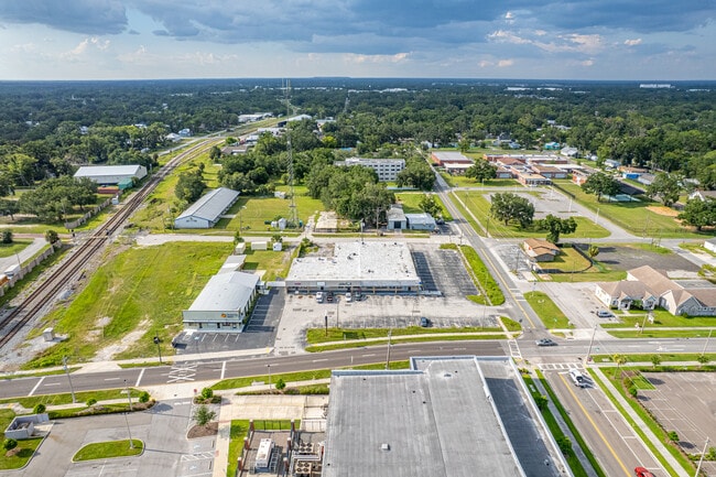
Property Record
408 W Baker St, Plant City, FL 33563
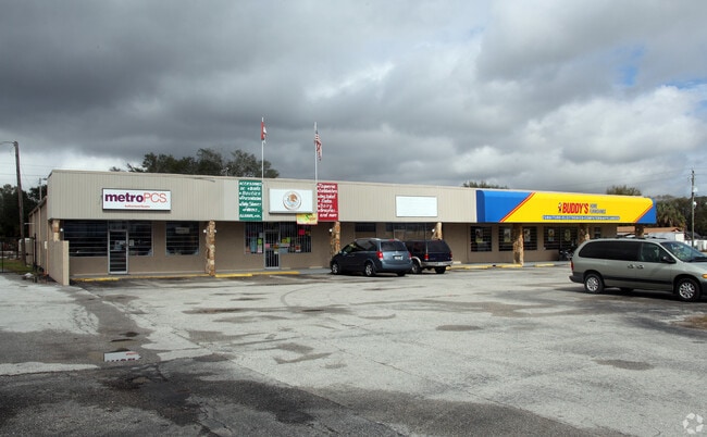
This Property Is For Sale
NEARBY LISTINGS FOR SALE OR LEASE
Property Detail
408 W Baker St
Tampa-St. Petersburg-Clearwater, FL
Revised Map Of Plant City
P-29-28-22-5D9-000009-00003.1
PLANT CITY REVISED MAP W 70 FT OF LOT 3 BLOCK 9
Residentialacreage
Hillsborough
X
Florida
12057C0269H
3
2024
0.16 AC
2024
Eastern Outlying
012702
Tampa/St Petersburg
1,472 SF
DEMOGRAPHICS near 408 W Baker St
1 Mile
3 Mile
5 Mile
2024 Total Population
10,569
41,078
69,039
2029 Population
11,548
44,932
75,511
Pop Growth 2024-2029
+ 9.26%
+ 9.38%
+ 9.37%
Average Age
37
39
39
2024 Total Households
3,675
14,824
24,096
HH Growth 2024-2029
+ 9.58%
+ 9.68%
+ 9.67%
Median Household Inc
$51,960
$51,992
$59,296
Avg Household Size
2.80
2.70
2.80
2024 Avg HH Vehicles
2.00
2.00
2.00
Median Home Value
$179,402
$196,554
$245,805
Median Year Built
1972
1985
1987
Nearby Places
Map Layers
Map Styles
 Street
 Aerial
- Restaurants
- Banks
- Shops
- Fitness
- Groceries
PUBLIC TRANSPORTATION
AIRPORT
Tampa International
DRIVE
WALK
Distance
Tampa International
40 min
29.8 mi
Freight Ports
Port of Tampa Bay
DRIVE
WALK
Distance
Port of Tampa Bay
33 min
23.3 mi
Nearby Properties
Address
Land Use
TOTAL SIZE
Lot Size
Zoning
Address
Land Use
TOTAL SIZE
Lot Size
Zoning
1,055,503 SF
112.72 AC
R-4
Address
Land Use
TOTAL SIZE
Lot Size
Zoning
519,942 SF
130.03 AC
I
Address
Land Use
TOTAL SIZE
Lot Size
Zoning
286,824 SF
43.15 AC
PD
Address
Land Use
TOTAL SIZE
Lot Size
Zoning
605,109 SF
141.96 AC
PD
Address
Land Use
TOTAL SIZE
Lot Size
Zoning
505,506 SF
50.60 AC
MU-R/C/I
Address
Land Use
TOTAL SIZE
Lot Size
Zoning
235,102 SF
7.73 AC
P
Address
Land Use
TOTAL SIZE
Lot Size
Zoning
415,389 SF
62.31 AC
MU-R/C/I
Address
Land Use
TOTAL SIZE
Lot Size
Zoning
243,294 SF
19.80 AC
CC
Address
Land Use
TOTAL SIZE
Lot Size
Zoning
333,718 SF
28.99 AC
I
Address
Land Use
TOTAL SIZE
Lot Size
Zoning
296,496 SF
77.52 AC
P
Address
Land Use
TOTAL SIZE
Lot Size
Zoning
492,180 SF
32.61 AC
PD
Address
Land Use
TOTAL SIZE
Lot Size
Zoning
496,217 SF
35.02 AC
I
Address
Land Use
TOTAL SIZE
Lot Size
Zoning
93,924 SF
3.96 AC
DC
Address
Land Use
TOTAL SIZE
Lot Size
Zoning
213,188 SF
16.10 AC
PD
Address
Land Use
TOTAL SIZE
Lot Size
Zoning
152,518 SF
43.50 AC
C-1A
Address
Land Use
TOTAL SIZE
Lot Size
Zoning
35,426 SF
39.92 AC
P
Address
Land Use
TOTAL SIZE
Lot Size
Zoning
145,222 SF
36.47 AC
PD
Address
Land Use
TOTAL SIZE
Lot Size
Zoning
192,911 SF
16.36 AC
PD
Address
Land Use
TOTAL SIZE
Lot Size
Zoning
177,038 SF
16.95 AC
PD
Address
Land Use
TOTAL SIZE
Lot Size
Zoning
202,712 SF
28.41 AC
C
Address
Land Use
TOTAL SIZE
Lot Size
Zoning
247,608 SF
25.84 AC
PD
Address
Land Use
TOTAL SIZE
Lot Size
Zoning
122,814 SF
17.18 AC
I
Address
Land Use
TOTAL SIZE
Lot Size
Zoning
154,237 SF
17.92 AC
C
Address
Land Use
TOTAL SIZE
Lot Size
Zoning
132,285 SF
30.77 AC
PD
Address
Land Use
TOTAL SIZE
Lot Size
Zoning
252,166 SF
22.88 AC
I
Address
Land Use
TOTAL SIZE
Lot Size
Zoning
169,563 SF
12.27 AC
I
Address
Land Use
TOTAL SIZE
Lot Size
Zoning
122,234 SF
191.15 AC
I
Address
Land Use
TOTAL SIZE
Lot Size
Zoning
159,805 SF
78.29 AC
P
Address
Land Use
TOTAL SIZE
Lot Size
Zoning
101,815 SF
15.76 AC
I
Address
Land Use
TOTAL SIZE
Lot Size
Zoning
139,392 SF
73.31 AC
RO
The World's #1 Commercial Real Estate Marketplace
Connect with us
© 2025 CoStar Group
The information above has been obtained from sources believed reliable. While we do not doubt its accuracy we have not verified it and make no guarantee, warranty or representation about it. It is your responsibility to independently confirm its accuracy and completeness. Any projections, opinions, assumptions, or estimates used are for example only and do not represent the current or future performance of the property. The value of this transaction to you depends on tax and other factors which should be evaluated by your tax, financial, and legal advisors. You and your advisors should conduct a careful, independent investigation of the property to determine to your satisfaction the suitability of the property for your needs.