Property Record
4080 2Nd Ave, Laurel Hill, FL 32567

Property Detail
4080 2Nd Ave
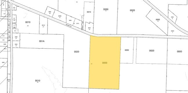
04-5N-22-0000-0040-0000
E1/2 OF SE1/4 OF NW1/4 861-755 BEG SW COR OF NE1/4 N 1272.02 FT TO R/W E 103.24 FT S 2 DEG W 1272.36 FT W 76 FT TO POB
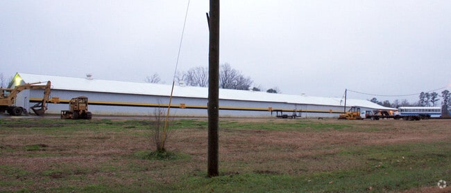
Bowlingalley
Okaloosa
B and X Area of moderate flood hazard, usually the area between the limits of the 100-year and 500-year floods.
Florida
2025
22.32 AC
2025
Fort Walton Beach
020200
Other Market Areas
23,234 SF
Crestview-Fort Walton Beach-Destin, FL
NEARBY LISTINGS FOR SALE OR LEASE
-
-
View all Laurel Hill listings for sale on LoopNet.com
DEMOGRAPHICS near 4080 2Nd Ave
1 mile
3 mile
5 mile
2025 Total Population
470
1,174
2,121
2030 Population
500
1,246
2,238
Pop Growth 2025-2030
+ 6.38%
+ 6.13%
+ 5.52%
Average Age
44
44
44
2025 Total Households
185
463
840
HH Growth 2025-2030
+ 5.95%
+ 5.83%
+ 5.24%
Median Household Inc
$78,125
$77,525
$74,594
Avg Household Size
2.60
2.60
2.50
2025 Avg HH Vehicles
2.00
2.00
2.00
Median Home Value
$283,333
$274,999
$251,418
Median Year Built
1990
1990
1989
Nearby Places
Map Layers
Map Styles
 Street
 Aerial
Layers
 Traffic
 Biking
Places
Listings with unknown addresses are not visible on the map
- Restaurants
- Banks
- Shops
- Fitness
- Groceries
Nearby Properties
Address
Land Use
TOTAL SIZE
Lot Size
Zoning
Address
Land Use
TOTAL SIZE
Lot Size
Zoning
90,840 SF
14.33 AC
Address
Land Use
TOTAL SIZE
Lot Size
Zoning
10,735 SF
1.62 AC
Address
Land Use
TOTAL SIZE
Lot Size
Zoning
9,230 SF
1.78 AC
Address
Land Use
TOTAL SIZE
Lot Size
Zoning
Address
Land Use
TOTAL SIZE
Lot Size
Zoning
4,438 SF
428 AC
Address
Land Use
TOTAL SIZE
Lot Size
Zoning
4,301 SF
10 AC
Address
Land Use
TOTAL SIZE
Lot Size
Zoning
9,293 SF
19 AC
Address
Land Use
TOTAL SIZE
Lot Size
Zoning
4,246 SF
19.50 AC
Address
Land Use
TOTAL SIZE
Lot Size
Zoning
3,484 SF
146.81 AC
Address
Land Use
TOTAL SIZE
Lot Size
Zoning
4,079 SF
36 AC
Address
Land Use
TOTAL SIZE
Lot Size
Zoning
4,246 SF
26 AC
Address
Land Use
TOTAL SIZE
Lot Size
Zoning
6,516 SF
15.75 AC
Address
Land Use
TOTAL SIZE
Lot Size
Zoning
5,738 SF
17.77 AC
Address
Land Use
TOTAL SIZE
Lot Size
Zoning
11,136 SF
64.40 AC
Address
Land Use
TOTAL SIZE
Lot Size
Zoning
3,846 SF
55.80 AC
Address
Land Use
TOTAL SIZE
Lot Size
Zoning
8,844 SF
5 AC
Address
Land Use
TOTAL SIZE
Lot Size
Zoning
4,861 SF
14.12 AC
Address
Land Use
TOTAL SIZE
Lot Size
Zoning
4,628 SF
50.86 AC
Address
Land Use
TOTAL SIZE
Lot Size
Zoning
3,436 SF
54.60 AC
Address
Land Use
TOTAL SIZE
Lot Size
Zoning
Address
Land Use
TOTAL SIZE
Lot Size
Zoning
2,885 SF
6.50 AC
Address
Land Use
TOTAL SIZE
Lot Size
Zoning
2,990 SF
20.95 AC
Address
Land Use
TOTAL SIZE
Lot Size
Zoning
4,661 SF
4.13 AC
Address
Land Use
TOTAL SIZE
Lot Size
Zoning
4,041 SF
20.10 AC
Address
Land Use
TOTAL SIZE
Lot Size
Zoning
3,855 SF
39 AC
Address
Land Use
TOTAL SIZE
Lot Size
Zoning
Address
Land Use
TOTAL SIZE
Lot Size
Zoning
10,839 SF
2.53 AC
Address
Land Use
TOTAL SIZE
Lot Size
Zoning
5,343 SF
20 AC
Address
Land Use
TOTAL SIZE
Lot Size
Zoning
2,639 SF
60 AC
The World's #1 Commercial Real Estate Marketplace
Connect with us
© 2026 CoStar Group
The information above has been obtained from sources believed reliable. While we do not doubt its accuracy we have not verified it and make no guarantee, warranty or representation about it. It is your responsibility to independently confirm its accuracy and completeness. Any projections, opinions, assumptions, or estimates used are for example only and do not represent the current or future performance of the property. The value of this transaction to you depends on tax and other factors which should be evaluated by your tax, financial, and legal advisors. You and your advisors should conduct a careful, independent investigation of the property to determine to your satisfaction the suitability of the property for your needs.