Property Record
4080 Camelot Ridge Dr Se, Grand Rapids, MI 49546
NEARBY LISTINGS FOR SALE OR LEASE
Property Detail
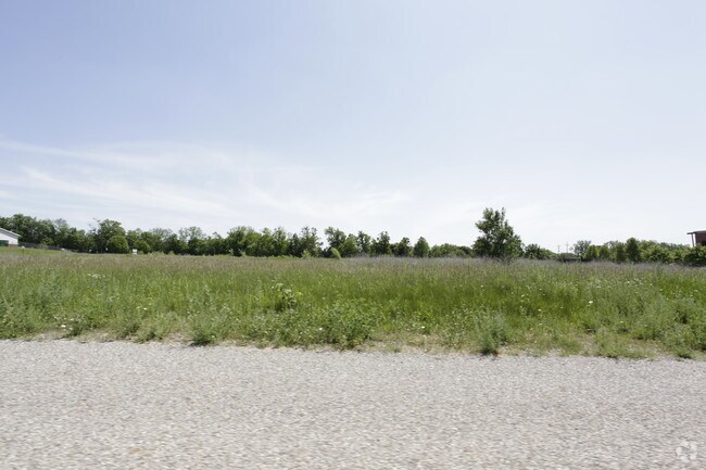
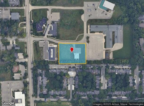
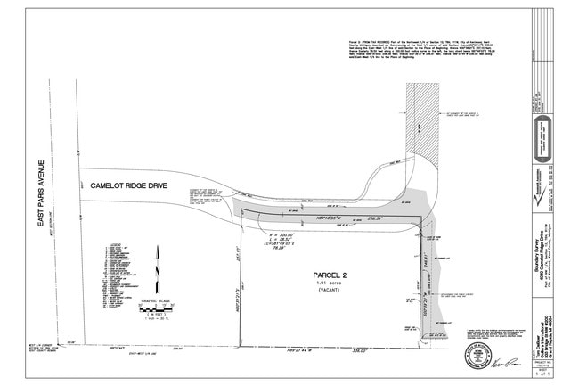
4080 Camelot Ridge Dr Se
41-18-12-101-049
PART OF NW 1/4 COM 347.71 FT S 89D 21M 44S E FROM W 1/4 COR TH N 0D 40M 25S E 254.86 FT TH ELY 69.35 FT ALONG A 300.0 FT RAD
Commercialnec
Kent
X
Michigan
26081C0437D
1.91 AC
2024
SE Grand Rapids/Cascade
2025
West Michigan
012610
Grand Rapids-Wyoming, MI
DEMOGRAPHICS near 4080 Camelot Ridge Dr Se
1 Mile
3 Mile
5 Mile
2024 Total Population
9,466
59,035
165,162
2029 Population
9,541
59,513
166,319
Pop Growth 2024-2029
+ 0.79%
+ 0.81%
+ 0.70%
Average Age
36
40
38
2024 Total Households
3,693
23,574
62,621
HH Growth 2024-2029
+ 0.92%
+ 0.82%
+ 0.69%
Median Household Inc
$54,634
$78,982
$77,462
Avg Household Size
2.20
2.30
2.50
2024 Avg HH Vehicles
1.00
2.00
2.00
Median Home Value
$286,065
$305,076
$269,177
Median Year Built
1982
1979
1972
Nearby Places
Map Layers
Map Styles
 Street
 Aerial
- Restaurants
- Banks
- Shops
- Fitness
- Groceries
PUBLIC TRANSPORTATION
AIRPORT
Gerald R Ford International
DRIVE
WALK
Distance
Gerald R Ford International
13 min
6.2 mi
Freight Ports
Port Milwaukee
DRIVE
WALK
Distance
Port Milwaukee
315 min
266.5 mi
SALE & LEASE HISTORY
LISTING DATE
SALE/LEASE

Sep 24, 2016
For Sale
Nov 17, 2016
For Sale
May 05, 2017
For Sale
Aug 18, 2017
For Sale
Nearby Properties
Address
Land Use
TOTAL SIZE
Lot Size
Zoning
Address
Land Use
TOTAL SIZE
Lot Size
Zoning
563,998 SF
31.75 AC
C3
Address
Land Use
TOTAL SIZE
Lot Size
Zoning
385,631 SF
45.27 AC
R-PUD-1
Address
Land Use
TOTAL SIZE
Lot Size
Zoning
476,572 SF
51.60 AC
R4
Address
Land Use
TOTAL SIZE
Lot Size
Zoning
446,986 SF
72.57 AC
R4
Address
Land Use
TOTAL SIZE
Lot Size
Zoning
521,735 SF
52.16 AC
MON-C
Address
Land Use
TOTAL SIZE
Lot Size
Zoning
709,488 SF
106.95 AC
LI
Address
Land Use
TOTAL SIZE
Lot Size
Zoning
126,805 SF
9.36 AC
C4
Address
Land Use
TOTAL SIZE
Lot Size
Zoning
151,708 SF
7.22 AC
C4
Address
Land Use
TOTAL SIZE
Lot Size
Zoning
Address
Land Use
TOTAL SIZE
Lot Size
Zoning
341,808 SF
27.73 AC
HC-PUD
Address
Land Use
TOTAL SIZE
Lot Size
Zoning
23.99 AC
PUD
Address
Land Use
TOTAL SIZE
Lot Size
Zoning
223,931 SF
18 AC
R-PUD-1
Address
Land Use
TOTAL SIZE
Lot Size
Zoning
194,153 SF
15.84 AC
MCN-C
Address
Land Use
TOTAL SIZE
Lot Size
Zoning
22.46 AC
MON-MDR
Address
Land Use
TOTAL SIZE
Lot Size
Zoning
226,877 SF
22.40 AC
R2
Address
Land Use
TOTAL SIZE
Lot Size
Zoning
19.40 AC
MON-MDR
Address
Land Use
TOTAL SIZE
Lot Size
Zoning
127,141 SF
17.04 AC
C2
Address
Land Use
TOTAL SIZE
Lot Size
Zoning
455,880 SF
24.91 AC
I1
Address
Land Use
TOTAL SIZE
Lot Size
Zoning
285,875 SF
37.86 AC
TI
Address
Land Use
TOTAL SIZE
Lot Size
Zoning
138,278 SF
35.63 AC
R-1
Address
Land Use
TOTAL SIZE
Lot Size
Zoning
15.94 AC
MON-MDR
Address
Land Use
TOTAL SIZE
Lot Size
Zoning
400,646 SF
23.78 AC
I1
Address
Land Use
TOTAL SIZE
Lot Size
Zoning
97,263 SF
19.37 AC
MON-MDR
Address
Land Use
TOTAL SIZE
Lot Size
Zoning
13.71 AC
MCN-LDR
Address
Land Use
TOTAL SIZE
Lot Size
Zoning
330,346 SF
49.71 AC
I1
Address
Land Use
TOTAL SIZE
Lot Size
Zoning
304,200 SF
R1
Address
Land Use
TOTAL SIZE
Lot Size
Zoning
16.91 AC
MON-MDR
Address
Land Use
TOTAL SIZE
Lot Size
Zoning
154,643 SF
10.96 AC
O-PUD
Address
Land Use
TOTAL SIZE
Lot Size
Zoning
146,732 SF
21.16 AC
R4
Address
Land Use
TOTAL SIZE
Lot Size
Zoning
258,128 SF
20.41 AC
R4
The World's #1 Commercial Real Estate Marketplace
Connect with us
© 2025 CoStar Group
The information above has been obtained from sources believed reliable. While we do not doubt its accuracy we have not verified it and make no guarantee, warranty or representation about it. It is your responsibility to independently confirm its accuracy and completeness. Any projections, opinions, assumptions, or estimates used are for example only and do not represent the current or future performance of the property. The value of this transaction to you depends on tax and other factors which should be evaluated by your tax, financial, and legal advisors. You and your advisors should conduct a careful, independent investigation of the property to determine to your satisfaction the suitability of the property for your needs.