Property Record
4080 Lyman Dr, Hilliard, OH 43026
NEARBY LISTINGS FOR SALE OR LEASE
Property Detail
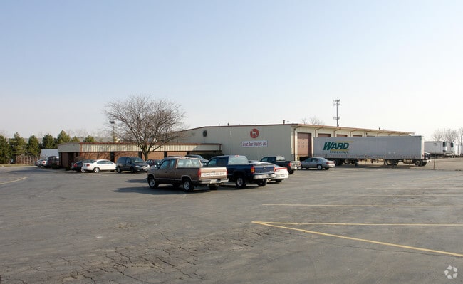
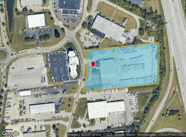
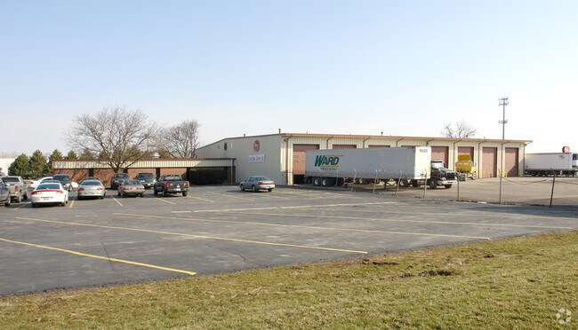
4080 Lyman Dr
050-003022
4080 LYMAN DRIVE ENTRY 3000 6.676 ACRES
Truckterminal
Franklin
X
Ohio
39097C0100D
6.68 AC
2024
Hilliard
2024
Columbus
007922
Columbus, OH
21,088 SF
DEMOGRAPHICS near 4080 Lyman Dr
1 Mile
3 Mile
5 Mile
2024 Total Population
5,590
88,409
209,918
2029 Population
5,574
87,713
209,238
Pop Growth 2024-2029
(0.29%)
(0.79%)
(0.32%)
Average Age
41
38
38
2024 Total Households
2,571
36,929
89,483
HH Growth 2024-2029
(0.16%)
(0.78%)
(0.32%)
Median Household Inc
$97,173
$92,826
$90,248
Avg Household Size
2.10
2.40
2.30
2024 Avg HH Vehicles
2.00
2.00
2.00
Median Home Value
$295,507
$298,655
$311,241
Median Year Built
1995
1992
1989
Nearby Places
Map Layers
Map Styles
 Street
 Aerial
- Restaurants
- Banks
- Shops
- Fitness
- Groceries
PUBLIC TRANSPORTATION
AIRPORT
John Glenn Columbus International
DRIVE
WALK
Distance
John Glenn Columbus International
26 min
18.3 mi
Rickenbacker International
DRIVE
WALK
Distance
Rickenbacker International
31 min
22.9 mi
Freight Ports
Port of Toledo
DRIVE
WALK
Distance
Port of Toledo
177 min
130.6 mi
Nearby Properties
Address
Land Use
TOTAL SIZE
Lot Size
Zoning
Address
Land Use
TOTAL SIZE
Lot Size
Zoning
768,498 SF
55.17 AC
Address
Land Use
TOTAL SIZE
Lot Size
Zoning
880,352 SF
94.89 AC
Address
Land Use
TOTAL SIZE
Lot Size
Zoning
327,525 SF
70.58 AC
Address
Land Use
TOTAL SIZE
Lot Size
Zoning
529,001 SF
28.39 AC
Address
Land Use
TOTAL SIZE
Lot Size
Zoning
419,285 SF
17.19 AC
Address
Land Use
TOTAL SIZE
Lot Size
Zoning
260,092 SF
29.05 AC
Address
Land Use
TOTAL SIZE
Lot Size
Zoning
549,907 SF
35.81 AC
Address
Land Use
TOTAL SIZE
Lot Size
Zoning
133,910 SF
14.48 AC
Address
Land Use
TOTAL SIZE
Lot Size
Zoning
158,471 SF
19.11 AC
Address
Land Use
TOTAL SIZE
Lot Size
Zoning
46,231 SF
27.42 AC
Address
Land Use
TOTAL SIZE
Lot Size
Zoning
91,413 SF
0.14 AC
Address
Land Use
TOTAL SIZE
Lot Size
Zoning
160,760 SF
14.29 AC
Address
Land Use
TOTAL SIZE
Lot Size
Zoning
284,923 SF
15.78 AC
Address
Land Use
TOTAL SIZE
Lot Size
Zoning
47,334 SF
29.34 AC
Address
Land Use
TOTAL SIZE
Lot Size
Zoning
195,867 SF
14.13 AC
Address
Land Use
TOTAL SIZE
Lot Size
Zoning
110,180 SF
29.07 AC
Address
Land Use
TOTAL SIZE
Lot Size
Zoning
110,344 SF
19.06 AC
Address
Land Use
TOTAL SIZE
Lot Size
Zoning
446,488 SF
45.12 AC
Address
Land Use
TOTAL SIZE
Lot Size
Zoning
163,895 SF
36.52 AC
Address
Land Use
TOTAL SIZE
Lot Size
Zoning
271,295 SF
14.75 AC
Address
Land Use
TOTAL SIZE
Lot Size
Zoning
67,186 SF
21.51 AC
Address
Land Use
TOTAL SIZE
Lot Size
Zoning
142,979 SF
6.50 AC
Address
Land Use
TOTAL SIZE
Lot Size
Zoning
216,795 SF
10.21 AC
Address
Land Use
TOTAL SIZE
Lot Size
Zoning
226,566 SF
14.88 AC
Address
Land Use
TOTAL SIZE
Lot Size
Zoning
105,351 SF
9.88 AC
Address
Land Use
TOTAL SIZE
Lot Size
Zoning
98,316 SF
10.81 AC
Address
Land Use
TOTAL SIZE
Lot Size
Zoning
156,030 SF
31.29 AC
Address
Land Use
TOTAL SIZE
Lot Size
Zoning
73,944 SF
11.03 AC
Address
Land Use
TOTAL SIZE
Lot Size
Zoning
21,238 SF
14.67 AC
Address
Land Use
TOTAL SIZE
Lot Size
Zoning
186,094 SF
13.06 AC
The World's #1 Commercial Real Estate Marketplace
Connect with us
© 2025 CoStar Group
The information above has been obtained from sources believed reliable. While we do not doubt its accuracy we have not verified it and make no guarantee, warranty or representation about it. It is your responsibility to independently confirm its accuracy and completeness. Any projections, opinions, assumptions, or estimates used are for example only and do not represent the current or future performance of the property. The value of this transaction to you depends on tax and other factors which should be evaluated by your tax, financial, and legal advisors. You and your advisors should conduct a careful, independent investigation of the property to determine to your satisfaction the suitability of the property for your needs.