Property Record
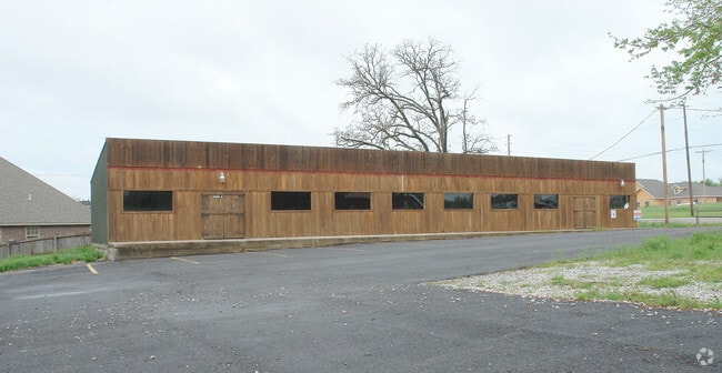
4080 N Thompson St, Springdale, AR 72764


NEARBY LISTINGS FOR SALE OR LEASE
Property Detail
4080 N Thompson St
21-00203-000
Springdale
Restaurantbuilding
PART OF THE SE OF THE NE OF SECTION 23, TOWHSHIP 18 NORTH, RANGE 30 WEST, BENTON COUNTY, ARKANSAS, AND BEING MORE PARTICULARLY DESCRIBED AS FOLLOWS: BEGINNING AT THE NE CORNER OF THE SE 1/4 OF SAID NE 1/4 SECTION 23; THENCE S02*3952W 294.25 FEET;
X
Benton
05143C0060G
Arkansas
2025
2.14 AC
2025
Greater Springdale
021314
Fayetteville/Springdale/Rogers
7,104 SF
Fayetteville-Springdale-Rogers, AR-MO
DEMOGRAPHICS near 4080 N Thompson St
1 Mile
3 Mile
5 Mile
2024 Total Population
4,812
43,797
108,049
2029 Population
5,505
48,888
121,132
Pop Growth 2024-2029
+ 14.40%
+ 11.62%
+ 12.11%
Average Age
35
35
34
2024 Total Households
1,440
13,499
34,791
HH Growth 2024-2029
+ 14.58%
+ 11.84%
+ 12.41%
Median Household Inc
$80,879
$66,243
$69,008
Avg Household Size
3.20
3.10
3.00
2024 Avg HH Vehicles
3.00
2.00
2.00
Median Home Value
$255,599
$186,665
$223,585
Median Year Built
1998
1991
1996
Nearby Places
Map Layers
Map Styles
 Street
 Aerial
- Restaurants
- Banks
- Shops
- Fitness
- Groceries
PUBLIC TRANSPORTATION
AIRPORT
Northwest Arkansas Ntl
DRIVE
WALK
Distance
Northwest Arkansas Ntl
29 min
14.4 mi
Freight Ports
Tulsa Port of Inola
DRIVE
WALK
Distance
Tulsa Port of Inola
106 min
90.0 mi
Nearby Properties
Address
Land Use
TOTAL SIZE
Lot Size
Zoning
Address
Land Use
TOTAL SIZE
Lot Size
Zoning
367,076 SF
57.31 AC
Address
Land Use
TOTAL SIZE
Lot Size
Zoning
58,764 SF
1.56 AC
Address
Land Use
TOTAL SIZE
Lot Size
Zoning
403,089 SF
1.93 AC
Address
Land Use
TOTAL SIZE
Lot Size
Zoning
153,718 SF
Address
Land Use
TOTAL SIZE
Lot Size
Zoning
251,508 SF
30 AC
Address
Land Use
TOTAL SIZE
Lot Size
Zoning
132,494 SF
21.56 AC
Address
Land Use
TOTAL SIZE
Lot Size
Zoning
306,148 SF
48.89 AC
Address
Land Use
TOTAL SIZE
Lot Size
Zoning
191,100 SF
10.03 AC
Address
Land Use
TOTAL SIZE
Lot Size
Zoning
75,610 SF
5.62 AC
Address
Land Use
TOTAL SIZE
Lot Size
Zoning
249,393 SF
10.70 AC
Address
Land Use
TOTAL SIZE
Lot Size
Zoning
292,470 SF
17.27 AC
Address
Land Use
TOTAL SIZE
Lot Size
Zoning
174,333 SF
25 AC
I1I2
Address
Land Use
TOTAL SIZE
Lot Size
Zoning
16,698 SF
1.11 AC
Address
Land Use
TOTAL SIZE
Lot Size
Zoning
348,916 SF
24.69 AC
Address
Land Use
TOTAL SIZE
Lot Size
Zoning
224,408 SF
9.80 AC
I1
Address
Land Use
TOTAL SIZE
Lot Size
Zoning
127,043 SF
6.82 AC
Address
Land Use
TOTAL SIZE
Lot Size
Zoning
206,446 SF
17.14 AC
Address
Land Use
TOTAL SIZE
Lot Size
Zoning
12,882 SF
12.33 AC
Address
Land Use
TOTAL SIZE
Lot Size
Zoning
31,150 SF
3.74 AC
C1
Address
Land Use
TOTAL SIZE
Lot Size
Zoning
182,415 SF
68.93 AC
Address
Land Use
TOTAL SIZE
Lot Size
Zoning
182,415 SF
12.04 AC
Address
Land Use
TOTAL SIZE
Lot Size
Zoning
80,475 SF
0.45 AC
C3
Address
Land Use
TOTAL SIZE
Lot Size
Zoning
73,711 SF
3.59 AC
Address
Land Use
TOTAL SIZE
Lot Size
Zoning
61,012 SF
18.96 AC
Address
Land Use
TOTAL SIZE
Lot Size
Zoning
147,762 SF
Address
Land Use
TOTAL SIZE
Lot Size
Zoning
123,740 SF
13.96 AC
Address
Land Use
TOTAL SIZE
Lot Size
Zoning
170,442 SF
12.62 AC
Address
Land Use
TOTAL SIZE
Lot Size
Zoning
160,570 SF
20.31 AC
Address
Land Use
TOTAL SIZE
Lot Size
Zoning
352,195 SF
15 AC
Address
Land Use
TOTAL SIZE
Lot Size
Zoning
54,460 SF
6.38 AC
The World's #1 Commercial Real Estate Marketplace
Connect with us
© 2025 CoStar Group
The information above has been obtained from sources believed reliable. While we do not doubt its accuracy we have not verified it and make no guarantee, warranty or representation about it. It is your responsibility to independently confirm its accuracy and completeness. Any projections, opinions, assumptions, or estimates used are for example only and do not represent the current or future performance of the property. The value of this transaction to you depends on tax and other factors which should be evaluated by your tax, financial, and legal advisors. You and your advisors should conduct a careful, independent investigation of the property to determine to your satisfaction the suitability of the property for your needs.