Property Record
4081 Indian Ripple Rd, Dayton, OH 45440


NEARBY LISTINGS FOR SALE OR LEASE
-
-
View all Dayton listings for sale on LoopNet.com
Property Detail
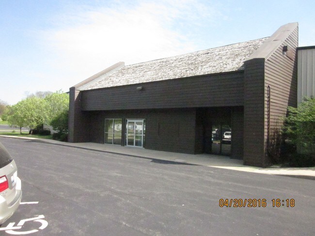
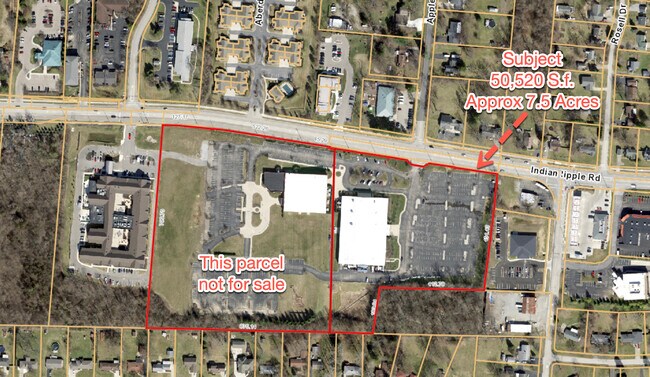
4081 Indian Ripple Rd
Dayton, OH
Vineyard Christian Fellowship
B42-0003-0010-0-0171-00
VINEYARD CHRISTIAN FELLOWSHIP SEC TWO LOT 1A 12.139AC INDIAN RIPPLE RD
Religious
Greene
X
Ohio
39057C0104E
1a
0
12.14 AC
2024
East Dayton
210401
Cincinnati/Dayton
50,520 SF
DEMOGRAPHICS near 4081 Indian Ripple Rd
1 Mile
3 Mile
5 Mile
2024 Total Population
7,417
48,075
161,117
2029 Population
7,540
48,281
160,828
Pop Growth 2024-2029
+ 1.66%
+ 0.43%
(0.18%)
Average Age
44
42
42
2024 Total Households
3,219
20,050
69,486
HH Growth 2024-2029
+ 1.68%
+ 0.26%
(0.28%)
Median Household Inc
$83,849
$82,650
$77,179
Avg Household Size
2.20
2.30
2.30
2024 Avg HH Vehicles
2.00
2.00
2.00
Median Home Value
$240,285
$203,575
$196,495
Median Year Built
1981
1967
1964
Nearby Places
Map Layers
Map Styles
 Street
 Aerial
- Restaurants
- Banks
- Shops
- Fitness
- Groceries
PUBLIC TRANSPORTATION
AIRPORT
James M Cox Dayton International
DRIVE
WALK
Distance
James M Cox Dayton International
34 min
20.4 mi
Freight Ports
Port of Toledo
DRIVE
WALK
Distance
Port of Toledo
191 min
160.6 mi
SALE & LEASE HISTORY
LISTING DATE
SALE/LEASE

Sep 24, 2016
For Sale
Sep 22, 2021
For Sale
Nearby Properties
Address
Land Use
TOTAL SIZE
Lot Size
Zoning
Address
Land Use
TOTAL SIZE
Lot Size
Zoning
752,874 SF
74.85 AC
Address
Land Use
TOTAL SIZE
Lot Size
Zoning
175,938 SF
49.33 AC
Address
Land Use
TOTAL SIZE
Lot Size
Zoning
53.48 AC
RP1
Address
Land Use
TOTAL SIZE
Lot Size
Zoning
1,951 SF
56.54 AC
Address
Land Use
TOTAL SIZE
Lot Size
Zoning
240,090 SF
1.93 AC
MXPUD02
Address
Land Use
TOTAL SIZE
Lot Size
Zoning
130,247 SF
14.12 AC
Address
Land Use
TOTAL SIZE
Lot Size
Zoning
Address
Land Use
TOTAL SIZE
Lot Size
Zoning
1,180 SF
23.28 AC
Address
Land Use
TOTAL SIZE
Lot Size
Zoning
38,832 SF
30.51 AC
R-PUD 03-7
Address
Land Use
TOTAL SIZE
Lot Size
Zoning
1,008 SF
7 AC
R1A
Address
Land Use
TOTAL SIZE
Lot Size
Zoning
109,680 SF
32.24 AC
R4
Address
Land Use
TOTAL SIZE
Lot Size
Zoning
130,766 SF
1.68 AC
Address
Land Use
TOTAL SIZE
Lot Size
Zoning
152,844 SF
14.80 AC
Address
Land Use
TOTAL SIZE
Lot Size
Zoning
70,754 SF
75.48 AC
Address
Land Use
TOTAL SIZE
Lot Size
Zoning
119,701 SF
71.85 AC
Address
Land Use
TOTAL SIZE
Lot Size
Zoning
89,176 SF
17.52 AC
Address
Land Use
TOTAL SIZE
Lot Size
Zoning
108,274 SF
25.09 AC
RPUD427
Address
Land Use
TOTAL SIZE
Lot Size
Zoning
100,450 SF
1.66 AC
MXPUD02
Address
Land Use
TOTAL SIZE
Lot Size
Zoning
148,309 SF
1.50 AC
MXPUD02
Address
Land Use
TOTAL SIZE
Lot Size
Zoning
24.77 AC
Address
Land Use
TOTAL SIZE
Lot Size
Zoning
309,331 SF
36 AC
Address
Land Use
TOTAL SIZE
Lot Size
Zoning
256,686 SF
11.05 AC
Address
Land Use
TOTAL SIZE
Lot Size
Zoning
20,144 SF
76.94 AC
A1
Address
Land Use
TOTAL SIZE
Lot Size
Zoning
134,260 SF
11.75 AC
Address
Land Use
TOTAL SIZE
Lot Size
Zoning
54,604 SF
6.29 AC
MXPUD02
Address
Land Use
TOTAL SIZE
Lot Size
Zoning
205,801 SF
37.77 AC
Address
Land Use
TOTAL SIZE
Lot Size
Zoning
20,832 SF
12.65 AC
Address
Land Use
TOTAL SIZE
Lot Size
Zoning
8,500 SF
11.26 AC
Address
Land Use
TOTAL SIZE
Lot Size
Zoning
72,824 SF
26.88 AC
A1
Address
Land Use
TOTAL SIZE
Lot Size
Zoning
318,166 SF
49.51 AC
The World's #1 Commercial Real Estate Marketplace
Connect with us
© 2026 CoStar Group
The information above has been obtained from sources believed reliable. While we do not doubt its accuracy we have not verified it and make no guarantee, warranty or representation about it. It is your responsibility to independently confirm its accuracy and completeness. Any projections, opinions, assumptions, or estimates used are for example only and do not represent the current or future performance of the property. The value of this transaction to you depends on tax and other factors which should be evaluated by your tax, financial, and legal advisors. You and your advisors should conduct a careful, independent investigation of the property to determine to your satisfaction the suitability of the property for your needs.