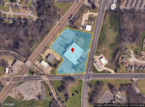
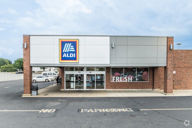
Property Record
4082 S Highway 61 St, Memphis, TN 38109

NEARBY LISTINGS FOR SALE OR LEASE
Property Detail
4082 S Highway 61 St
Memphis, TN-MS-AR
Wynona
07-5114-0-0010C
PART LOTS 32,33&25
Supermarket
Shelby
X
Tennessee
05035C0475E
32-33
0
5.82 AC
2025
South
022310
Memphis
44,840 SF
DEMOGRAPHICS near 4082 S Highway 61 St
1 Mile
3 Mile
5 Mile
2024 Total Population
9,176
60,009
141,319
2029 Population
8,955
59,689
142,982
Pop Growth 2024-2029
(2.41%)
(0.53%)
+ 1.18%
Average Age
39
38
38
2024 Total Households
3,627
23,092
54,627
HH Growth 2024-2029
(2.62%)
(0.59%)
+ 1.15%
Median Household Inc
$36,915
$40,324
$37,721
Avg Household Size
2.50
2.50
2.50
2024 Avg HH Vehicles
1.00
1.00
1.00
Median Home Value
$107,980
$86,657
$82,197
Median Year Built
1962
1964
1964
Nearby Places
Map Layers
Map Styles
 Street
 Aerial
- Restaurants
- Banks
- Shops
- Fitness
- Groceries
PUBLIC TRANSPORTATION
COMMUTER RAIL
Central Station (Riverfront Loop - Memphis Area Transit Authority Trolley (MataTrolley))
DRIVE
WALK
Distance
Central Station (Riverfront Loop - Memphis Area Transit Authority Trolley (MataTrolley))
12 min
7.1 mi
AIRPORT
Memphis International
DRIVE
WALK
Distance
Memphis International
11 min
6.6 mi
Nearby Properties
Address
Land Use
TOTAL SIZE
Lot Size
Zoning
Address
Land Use
TOTAL SIZE
Lot Size
Zoning
438,763 SF
64.67 AC
IH
Address
Land Use
TOTAL SIZE
Lot Size
Zoning
146,316 SF
18.07 AC
CMU-3
Address
Land Use
TOTAL SIZE
Lot Size
Zoning
95,307 SF
25.91 AC
RU-3
Address
Land Use
TOTAL SIZE
Lot Size
Zoning
214,950 SF
17.05 AC
CMU-2
Address
Land Use
TOTAL SIZE
Lot Size
Zoning
81,790 SF
17.82 AC
CMU-2
Address
Land Use
TOTAL SIZE
Lot Size
Zoning
147,890 SF
16.92 AC
EMP
Address
Land Use
TOTAL SIZE
Lot Size
Zoning
43,476 SF
4.62 AC
CMU-3
Address
Land Use
TOTAL SIZE
Lot Size
Zoning
233,060 SF
20 AC
EMP
Address
Land Use
TOTAL SIZE
Lot Size
Zoning
79,658 SF
7 AC
RU-3
Address
Land Use
TOTAL SIZE
Lot Size
Zoning
80,264 SF
10.15 AC
RU-3
Address
Land Use
TOTAL SIZE
Lot Size
Zoning
79,340 SF
7 AC
RU-3
Address
Land Use
TOTAL SIZE
Lot Size
Zoning
54,000 SF
293.13 AC
IH
Address
Land Use
TOTAL SIZE
Lot Size
Zoning
37,631 SF
3.39 AC
CMU-2
Address
Land Use
TOTAL SIZE
Lot Size
Zoning
318,661 SF
26.92 AC
CMU-3
Address
Land Use
TOTAL SIZE
Lot Size
Zoning
13,978 SF
7 AC
RU-3
Address
Land Use
TOTAL SIZE
Lot Size
Zoning
167,607 SF
5.52 AC
CMU-2
Address
Land Use
TOTAL SIZE
Lot Size
Zoning
142,333 SF
29.69 AC
CMU-3
Address
Land Use
TOTAL SIZE
Lot Size
Zoning
74,717 SF
4.74 AC
RU-3
Address
Land Use
TOTAL SIZE
Lot Size
Zoning
35,779 SF
13.37 AC
R-10
Address
Land Use
TOTAL SIZE
Lot Size
Zoning
370,000 SF
20.28 AC
EMP
Address
Land Use
TOTAL SIZE
Lot Size
Zoning
32,760 SF
2.09 AC
CMU-2
Address
Land Use
TOTAL SIZE
Lot Size
Zoning
12,789 SF
19.12 AC
RU-1
Address
Land Use
TOTAL SIZE
Lot Size
Zoning
22,408 SF
2.31 AC
CMU-1
Address
Land Use
TOTAL SIZE
Lot Size
Zoning
504,925 SF
43.01 AC
EMP
Address
Land Use
TOTAL SIZE
Lot Size
Zoning
35,280 SF
5.80 AC
CMU-3
Address
Land Use
TOTAL SIZE
Lot Size
Zoning
23,290 SF
3.49 AC
CMU-3
Address
Land Use
TOTAL SIZE
Lot Size
Zoning
59,254 SF
6.61 AC
CMU-2
Address
Land Use
TOTAL SIZE
Lot Size
Zoning
31,164 SF
3.09 AC
CMU-1
Address
Land Use
TOTAL SIZE
Lot Size
Zoning
128,704 SF
7.98 AC
RU-3
Address
Land Use
TOTAL SIZE
Lot Size
Zoning
91,965 SF
14.64 AC
RU-3
The World's #1 Commercial Real Estate Marketplace
Connect with us
© 2026 CoStar Group
The information above has been obtained from sources believed reliable. While we do not doubt its accuracy we have not verified it and make no guarantee, warranty or representation about it. It is your responsibility to independently confirm its accuracy and completeness. Any projections, opinions, assumptions, or estimates used are for example only and do not represent the current or future performance of the property. The value of this transaction to you depends on tax and other factors which should be evaluated by your tax, financial, and legal advisors. You and your advisors should conduct a careful, independent investigation of the property to determine to your satisfaction the suitability of the property for your needs.