Property Record
4085 Interstate 35 N, Lytle, TX 78052
Property Detail
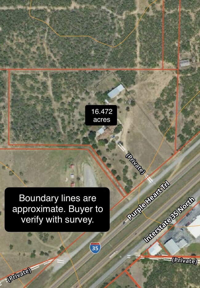
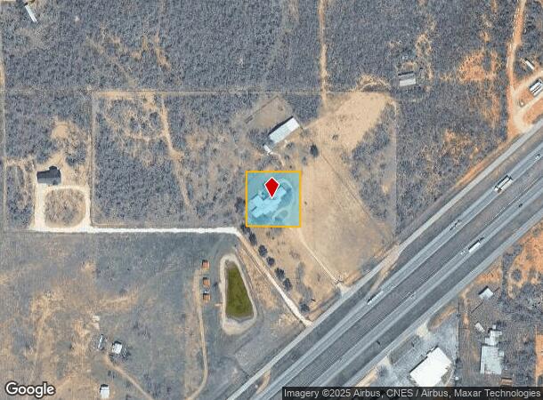
4085 Interstate 35 N
34844
D. Trimble Survey 519 1/2
Farms
A0968 D. TRIMBLE SURVEY 519 1/2; ACRES 1.0
X
Medina
48325C0700C
Texas
2024
1 AC
2025
Medina County
000401
San Antonio
5,748 SF
San Antonio-New Braunfels, TX
NEARBY LISTINGS FOR SALE OR LEASE
DEMOGRAPHICS near 4085 Interstate 35 N
1 mile
3 mile
5 mile
2024 Total Population
1,118
6,545
12,522
2029 Population
1,132
6,860
13,233
Pop Growth 2024-2029
+ 1.25%
+ 4.81%
+ 5.68%
Average Age
39
40
40
2024 Total Households
345
2,174
4,111
HH Growth 2024-2029
+ 1.45%
+ 5.11%
+ 6.01%
Median Household Inc
$55,217
$62,050
$64,562
Avg Household Size
3.10
3.00
3.00
2024 Avg HH Vehicles
2.00
2.00
2.00
Median Home Value
$153,846
$140,813
$154,955
Median Year Built
1987
1989
1989
Nearby Places
Map Layers
Map Styles
 Street
 Aerial
Transit
 Traffic
 Biking
Places
Listings with unknown addresses are not visible on the map
- Restaurants
- Banks
- Shops
- Fitness
- Groceries
PUBLIC TRANSPORTATION
AIRPORT
San Antonio International
Drive
Walk
Distance
San Antonio International
44 min
33.5 mi
Freight Ports
Port of Corpus Christi
Drive
Walk
Distance
Port of Corpus Christi
168 min
155.2 mi
SALE & LEASE HISTORY
LISTING DATE
SALE/LEASE

Jul 22, 2024
For Sale
Jul 22, 2024
For Sale
Feb 25, 2025
For Sale
Nearby Properties
Address
Land Use
TOTAL SIZE
Lot Size
Zoning
Address
Land Use
TOTAL SIZE
Lot Size
Zoning
112,135 SF
25.21 AC
Address
Land Use
TOTAL SIZE
Lot Size
Zoning
530,629 SF
17.05 AC
Address
Land Use
TOTAL SIZE
Lot Size
Zoning
21,136 SF
7.58 AC
Address
Land Use
TOTAL SIZE
Lot Size
Zoning
40,658 SF
1.76 AC
Address
Land Use
TOTAL SIZE
Lot Size
Zoning
32,030 SF
4.09 AC
Address
Land Use
TOTAL SIZE
Lot Size
Zoning
21,734 SF
2.49 AC
Address
Land Use
TOTAL SIZE
Lot Size
Zoning
38,975 SF
5.71 AC
Address
Land Use
TOTAL SIZE
Lot Size
Zoning
10,224 SF
1.42 AC
Address
Land Use
TOTAL SIZE
Lot Size
Zoning
13,418 SF
3.50 AC
Address
Land Use
TOTAL SIZE
Lot Size
Zoning
20,231 SF
1.40 AC
Address
Land Use
TOTAL SIZE
Lot Size
Zoning
28,953 SF
4.53 AC
Address
Land Use
TOTAL SIZE
Lot Size
Zoning
8,375 SF
0.72 AC
Address
Land Use
TOTAL SIZE
Lot Size
Zoning
6,783 SF
1.27 AC
Address
Land Use
TOTAL SIZE
Lot Size
Zoning
4,757 SF
4.80 AC
Address
Land Use
TOTAL SIZE
Lot Size
Zoning
19,800 SF
3.12 AC
Address
Land Use
TOTAL SIZE
Lot Size
Zoning
16,250 SF
1.99 AC
Address
Land Use
TOTAL SIZE
Lot Size
Zoning
10,590 SF
2.48 AC
Address
Land Use
TOTAL SIZE
Lot Size
Zoning
21,588 SF
1.10 AC
Address
Land Use
TOTAL SIZE
Lot Size
Zoning
16,491 SF
0.97 AC
Address
Land Use
TOTAL SIZE
Lot Size
Zoning
9,970 SF
11.08 AC
Address
Land Use
TOTAL SIZE
Lot Size
Zoning
8,246 SF
1.59 AC
Address
Land Use
TOTAL SIZE
Lot Size
Zoning
56,686 SF
11.20 AC
Address
Land Use
TOTAL SIZE
Lot Size
Zoning
11,380 SF
0.52 AC
Address
Land Use
TOTAL SIZE
Lot Size
Zoning
27.64 AC
Address
Land Use
TOTAL SIZE
Lot Size
Zoning
9,275 SF
2.91 AC
Address
Land Use
TOTAL SIZE
Lot Size
Zoning
9,500 SF
1.37 AC
Address
Land Use
TOTAL SIZE
Lot Size
Zoning
25,090 SF
2.71 AC
Address
Land Use
TOTAL SIZE
Lot Size
Zoning
8,600 SF
2 AC
The World's #1 Commercial Real Estate Marketplace
Connect with us
© 2026 CoStar Group
The information above has been obtained from sources believed reliable. While we do not doubt its accuracy we have not verified it and make no guarantee, warranty or representation about it. It is your responsibility to independently confirm its accuracy and completeness. Any projections, opinions, assumptions, or estimates used are for example only and do not represent the current or future performance of the property. The value of this transaction to you depends on tax and other factors which should be evaluated by your tax, financial, and legal advisors. You and your advisors should conduct a careful, independent investigation of the property to determine to your satisfaction the suitability of the property for your needs.