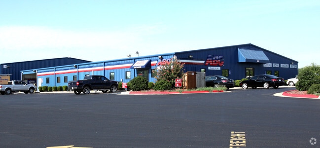
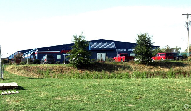
Property Record
409 E Apple Blossom Ave, Springdale, AR 72764

Property Detail
409 E Apple Blossom Ave
21-00104-025
PT E 1/2 NE NW BEG E 826.32 NW/C E443.02 S1*E1310.85 S88*W452.32 N0*W1324.24 POB SURVEY 2008-377
Shipyard
BENTON
B and X Area of moderate flood hazard, usually the area between the limits of the 100-year and 500-year floods.
Arkansas
2025
13.54 AC
2025
Greater Springdale
021406
Fayetteville/Springdale/Rogers
66,800 SF
Fayetteville-Springdale-Rogers, AR
NEARBY LISTINGS FOR SALE OR LEASE
DEMOGRAPHICS near 409 E Apple Blossom Ave
1 mile
3 mile
5 mile
2025 Total Population
3,656
29,576
103,147
2030 Population
4,058
32,293
112,044
Pop Growth 2025-2030
+ 11.00%
+ 9.19%
+ 8.63%
Average Age
35
35
35
2025 Total Households
1,100
9,260
32,995
HH Growth 2025-2030
+ 11.18%
+ 9.49%
+ 8.99%
Median Household Inc
$91,179
$81,812
$74,523
Avg Household Size
3.30
3.10
3.00
2025 Avg HH Vehicles
2.00
2.00
2.00
Median Home Value
$278,731
$292,376
$300,886
Median Year Built
1999
1998
1997
Nearby Places
Map Layers
Map Styles
 Street
 Aerial
Layers
 Traffic
 Biking
Places
Listings with unknown addresses are not visible on the map
- Restaurants
- Banks
- Shops
- Fitness
- Groceries
PUBLIC TRANSPORTATION
AIRPORT
Northwest Arkansas Ntl
Drive
Walk
Distance
Northwest Arkansas Ntl
28 min
13.6 mi
Freight Ports
Tulsa Port of Inola
Drive
Walk
Distance
Tulsa Port of Inola
109 min
91.3 mi
Nearby Properties
Address
Land Use
TOTAL SIZE
Lot Size
Zoning
Address
Land Use
TOTAL SIZE
Lot Size
Zoning
367,076 SF
57.31 AC
Address
Land Use
TOTAL SIZE
Lot Size
Zoning
251,508 SF
30 AC
Address
Land Use
TOTAL SIZE
Lot Size
Zoning
132,494 SF
21.56 AC
Address
Land Use
TOTAL SIZE
Lot Size
Zoning
306,148 SF
48.89 AC
Address
Land Use
TOTAL SIZE
Lot Size
Zoning
191,100 SF
10.03 AC
Address
Land Use
TOTAL SIZE
Lot Size
Zoning
75,610 SF
5.62 AC
Address
Land Use
TOTAL SIZE
Lot Size
Zoning
249,393 SF
10.70 AC
Address
Land Use
TOTAL SIZE
Lot Size
Zoning
292,470 SF
17.27 AC
Address
Land Use
TOTAL SIZE
Lot Size
Zoning
174,333 SF
25 AC
I1I2
Address
Land Use
TOTAL SIZE
Lot Size
Zoning
348,916 SF
24.69 AC
Address
Land Use
TOTAL SIZE
Lot Size
Zoning
29,670 SF
5.80 AC
Address
Land Use
TOTAL SIZE
Lot Size
Zoning
127,043 SF
6.82 AC
Address
Land Use
TOTAL SIZE
Lot Size
Zoning
206,446 SF
17.14 AC
Address
Land Use
TOTAL SIZE
Lot Size
Zoning
12,882 SF
12.33 AC
Address
Land Use
TOTAL SIZE
Lot Size
Zoning
39,793 SF
4.94 AC
Address
Land Use
TOTAL SIZE
Lot Size
Zoning
182,415 SF
68.93 AC
Address
Land Use
TOTAL SIZE
Lot Size
Zoning
182,415 SF
12.04 AC
Address
Land Use
TOTAL SIZE
Lot Size
Zoning
39,000 SF
16.38 AC
Address
Land Use
TOTAL SIZE
Lot Size
Zoning
73,711 SF
3.59 AC
Address
Land Use
TOTAL SIZE
Lot Size
Zoning
61,012 SF
18.96 AC
Address
Land Use
TOTAL SIZE
Lot Size
Zoning
147,762 SF
Address
Land Use
TOTAL SIZE
Lot Size
Zoning
123,740 SF
13.96 AC
Address
Land Use
TOTAL SIZE
Lot Size
Zoning
170,442 SF
12.62 AC
Address
Land Use
TOTAL SIZE
Lot Size
Zoning
160,570 SF
20.31 AC
Address
Land Use
TOTAL SIZE
Lot Size
Zoning
54,460 SF
6.38 AC
Address
Land Use
TOTAL SIZE
Lot Size
Zoning
40,456 SF
14.17 AC
Address
Land Use
TOTAL SIZE
Lot Size
Zoning
65,200 SF
9.26 AC
Address
Land Use
TOTAL SIZE
Lot Size
Zoning
150,076 SF
9.55 AC
Address
Land Use
TOTAL SIZE
Lot Size
Zoning
90,860 SF
5.80 AC
Address
Land Use
TOTAL SIZE
Lot Size
Zoning
51,376 SF
5.86 AC
The World's #1 Commercial Real Estate Marketplace
Connect with us
© 2026 CoStar Group
The information above has been obtained from sources believed reliable. While we do not doubt its accuracy we have not verified it and make no guarantee, warranty or representation about it. It is your responsibility to independently confirm its accuracy and completeness. Any projections, opinions, assumptions, or estimates used are for example only and do not represent the current or future performance of the property. The value of this transaction to you depends on tax and other factors which should be evaluated by your tax, financial, and legal advisors. You and your advisors should conduct a careful, independent investigation of the property to determine to your satisfaction the suitability of the property for your needs.