Property Record
409 Hampton Hwy, Yorktown, VA 23693
NEARBY LISTINGS FOR SALE OR LEASE
Property Detail
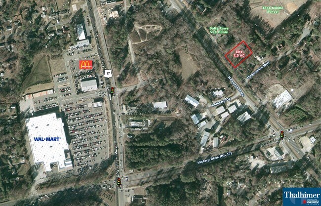
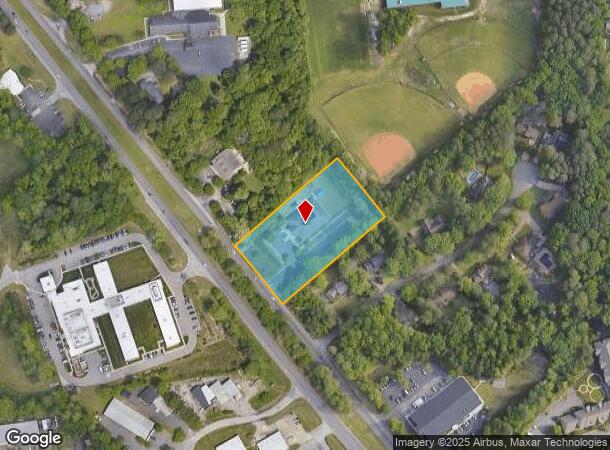
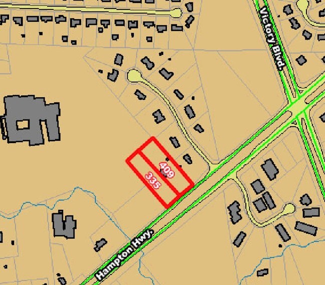
409 Hampton Hwy
S03B-4989-4490
Private School
Daycare
HAWKINS SANDRA FAYE ALIFF PROPERTY LINE VACATION PLAT
X
York
5155270001H
Virginia
2024
2.26 AC
2025
York
050205
Hampton Roads
8,738 SF
Virginia Beach-Norfolk-Newport News, VA-NC
DEMOGRAPHICS near 409 Hampton Hwy
1 Mile
3 Mile
5 Mile
2024 Total Population
6,099
59,639
162,014
2029 Population
6,451
61,109
163,183
Pop Growth 2024-2029
+ 5.77%
+ 2.46%
+ 0.72%
Average Age
43
39
39
2024 Total Households
2,214
23,314
64,716
HH Growth 2024-2029
+ 5.87%
+ 2.17%
+ 0.52%
Median Household Inc
$112,026
$89,296
$75,727
Avg Household Size
2.70
2.50
2.40
2024 Avg HH Vehicles
2.00
2.00
2.00
Median Home Value
$399,854
$337,526
$288,141
Median Year Built
1991
1991
1986
Nearby Places
Map Layers
Map Styles
 Street
 Aerial
- Restaurants
- Banks
- Shops
- Fitness
- Groceries
PUBLIC TRANSPORTATION
COMMUTER RAIL
Newport News (Northeast Regional - Amtrak)
DRIVE
WALK
Distance
Newport News (Northeast Regional - Amtrak)
17 min
8.8 mi
AIRPORT
Newport News/Williamsburg International
DRIVE
WALK
Distance
Newport News/Williamsburg International
12 min
5.7 mi
Norfolk International
DRIVE
WALK
Distance
Norfolk International
40 min
26.8 mi
Freight Ports
Virginia Port Authority - Newport News
DRIVE
WALK
Distance
Virginia Port Authority - Newport News
21 min
14.7 mi
Nearby Properties
Address
Land Use
TOTAL SIZE
Lot Size
Zoning
Address
Land Use
TOTAL SIZE
Lot Size
Zoning
717,621 SF
141.28 AC
M1
Address
Land Use
TOTAL SIZE
Lot Size
Zoning
464,936 SF
33.26 AC
R7
Address
Land Use
TOTAL SIZE
Lot Size
Zoning
565,343 SF
46.70 AC
C1
Address
Land Use
TOTAL SIZE
Lot Size
Zoning
75,168 SF
824.63 AC
M1
Address
Land Use
TOTAL SIZE
Lot Size
Zoning
393,640 SF
14.12 AC
PLANNED DE
Address
Land Use
TOTAL SIZE
Lot Size
Zoning
210,585 SF
32.06 AC
R9
Address
Land Use
TOTAL SIZE
Lot Size
Zoning
100 SF
7.27 AC
R9
Address
Land Use
TOTAL SIZE
Lot Size
Zoning
264,447 SF
2.30 AC
C4
Address
Land Use
TOTAL SIZE
Lot Size
Zoning
39,492 SF
798.51 AC
RESOURCE C
Address
Land Use
TOTAL SIZE
Lot Size
Zoning
71,551 SF
110 AC
O3
Address
Land Use
TOTAL SIZE
Lot Size
Zoning
4.62 AC
C4
Address
Land Use
TOTAL SIZE
Lot Size
Zoning
100 SF
7.68 AC
R9
Address
Land Use
TOTAL SIZE
Lot Size
Zoning
617 SF
73.49 AC
M1
Address
Land Use
TOTAL SIZE
Lot Size
Zoning
19.86 AC
R8
Address
Land Use
TOTAL SIZE
Lot Size
Zoning
2,095 SF
23.19 AC
MULTI-FAMI
Address
Land Use
TOTAL SIZE
Lot Size
Zoning
100 SF
14 AC
R7
Address
Land Use
TOTAL SIZE
Lot Size
Zoning
252 SF
17.21 AC
MULTI-FAMI
Address
Land Use
TOTAL SIZE
Lot Size
Zoning
5,389 SF
24.08 AC
RMF,LB
Address
Land Use
TOTAL SIZE
Lot Size
Zoning
517,920 SF
1.56 AC
C4
Address
Land Use
TOTAL SIZE
Lot Size
Zoning
13.10 AC
R5
Address
Land Use
TOTAL SIZE
Lot Size
Zoning
20.73 AC
R7
Address
Land Use
TOTAL SIZE
Lot Size
Zoning
4,037 SF
6.72 AC
PUDM
Address
Land Use
TOTAL SIZE
Lot Size
Zoning
3.95 AC
C4
Address
Land Use
TOTAL SIZE
Lot Size
Zoning
202 SF
18.37 AC
PLANNED DE
Address
Land Use
TOTAL SIZE
Lot Size
Zoning
60,000 SF
1.64 AC
C4
Address
Land Use
TOTAL SIZE
Lot Size
Zoning
4.60 AC
C4
Address
Land Use
TOTAL SIZE
Lot Size
Zoning
100 SF
16.23 AC
R7
Address
Land Use
TOTAL SIZE
Lot Size
Zoning
100 SF
11.10 AC
R7
Address
Land Use
TOTAL SIZE
Lot Size
Zoning
8.19 AC
R7
Address
Land Use
TOTAL SIZE
Lot Size
Zoning
140,400 SF
0.41 AC
C4
The World's #1 Commercial Real Estate Marketplace
Connect with us
© 2025 CoStar Group
The information above has been obtained from sources believed reliable. While we do not doubt its accuracy we have not verified it and make no guarantee, warranty or representation about it. It is your responsibility to independently confirm its accuracy and completeness. Any projections, opinions, assumptions, or estimates used are for example only and do not represent the current or future performance of the property. The value of this transaction to you depends on tax and other factors which should be evaluated by your tax, financial, and legal advisors. You and your advisors should conduct a careful, independent investigation of the property to determine to your satisfaction the suitability of the property for your needs.