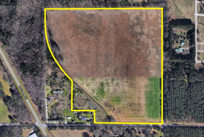
Property Record
409 Jim Mclemore Rd, Harvest, AL 35749

NEARBY LISTINGS FOR SALE OR LEASE
-
-
View all Harvest listings for sale on LoopNet.com
Property Detail
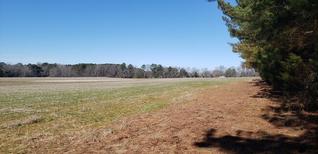
409 Jim Mclemore Rd
06-02-10-0-002-073.001
SEC 10 T2S R2W COMM AT SE COR OF SW 1/4 OF SW 1/4 OF SEC 10 TH N TO THE N MAR OF JIM MCLEMORE RD & THE POB TH N 1268 FT E 10
Vacantlandnec
Madison
X
Alabama
01089C0050E
1.50 AC
2025
North Madison County
2025
Huntsville
010502
Huntsville, AL
DEMOGRAPHICS near 409 Jim Mclemore Rd
1 Mile
3 Mile
5 Mile
2024 Total Population
1,183
11,880
28,610
2029 Population
1,326
13,264
31,876
Pop Growth 2024-2029
+ 12.09%
+ 11.65%
+ 11.42%
Average Age
38
39
39
2024 Total Households
441
4,324
10,481
HH Growth 2024-2029
+ 12.70%
+ 12.12%
+ 11.89%
Median Household Inc
$100,149
$92,669
$95,162
Avg Household Size
2.60
2.70
2.60
2024 Avg HH Vehicles
2.00
2.00
2.00
Median Home Value
$240,109
$233,550
$231,949
Median Year Built
2000
2002
2000
Nearby Places
Map Layers
Map Styles
 Street
 Aerial
- Restaurants
- Banks
- Shops
- Fitness
- Groceries
PUBLIC TRANSPORTATION
AIRPORT
Huntsville International-Carl T Jones Field
DRIVE
WALK
Distance
Huntsville International-Carl T Jones Field
31 min
21.7 mi
Freight Ports
Port of Mobile
DRIVE
WALK
Distance
Port of Mobile
399 min
362.9 mi
SALE & LEASE HISTORY
LISTING DATE
SALE/LEASE

Jun 03, 2021
For Sale
Nearby Properties
Address
Land Use
TOTAL SIZE
Lot Size
Zoning
Address
Land Use
TOTAL SIZE
Lot Size
Zoning
45,790 SF
13.39 AC
Address
Land Use
TOTAL SIZE
Lot Size
Zoning
Address
Land Use
TOTAL SIZE
Lot Size
Zoning
11,414 SF
7.60 AC
Address
Land Use
TOTAL SIZE
Lot Size
Zoning
Address
Land Use
TOTAL SIZE
Lot Size
Zoning
8,448 SF
5 AC
Address
Land Use
TOTAL SIZE
Lot Size
Zoning
24,300 SF
9.28 AC
Address
Land Use
TOTAL SIZE
Lot Size
Zoning
30,000 SF
3.40 AC
Address
Land Use
TOTAL SIZE
Lot Size
Zoning
2.51 AC
Address
Land Use
TOTAL SIZE
Lot Size
Zoning
6,967 SF
3.25 AC
Address
Land Use
TOTAL SIZE
Lot Size
Zoning
7,288 SF
1.12 AC
Address
Land Use
TOTAL SIZE
Lot Size
Zoning
5,760 SF
3.40 AC
Address
Land Use
TOTAL SIZE
Lot Size
Zoning
11,743 SF
0.95 AC
Address
Land Use
TOTAL SIZE
Lot Size
Zoning
10,000 SF
2.78 AC
Address
Land Use
TOTAL SIZE
Lot Size
Zoning
11,243 SF
9.10 AC
Address
Land Use
TOTAL SIZE
Lot Size
Zoning
7,870 SF
2.17 AC
Address
Land Use
TOTAL SIZE
Lot Size
Zoning
3,679 SF
1.31 AC
Address
Land Use
TOTAL SIZE
Lot Size
Zoning
3,511 SF
1.12 AC
Address
Land Use
TOTAL SIZE
Lot Size
Zoning
3,440 SF
1.49 AC
Address
Land Use
TOTAL SIZE
Lot Size
Zoning
1,152 SF
35 AC
Address
Land Use
TOTAL SIZE
Lot Size
Zoning
10,962 SF
2.28 AC
Address
Land Use
TOTAL SIZE
Lot Size
Zoning
2,790 SF
1.04 AC
Address
Land Use
TOTAL SIZE
Lot Size
Zoning
8,164 SF
6.50 AC
Address
Land Use
TOTAL SIZE
Lot Size
Zoning
3,630 SF
1.09 AC
Address
Land Use
TOTAL SIZE
Lot Size
Zoning
1,508 SF
89 AC
Address
Land Use
TOTAL SIZE
Lot Size
Zoning
7,500 SF
1.32 AC
Address
Land Use
TOTAL SIZE
Lot Size
Zoning
3,600 SF
3 AC
Address
Land Use
TOTAL SIZE
Lot Size
Zoning
5,810 SF
5.10 AC
Address
Land Use
TOTAL SIZE
Lot Size
Zoning
900 SF
4.90 AC
Address
Land Use
TOTAL SIZE
Lot Size
Zoning
14,058 SF
1.69 AC
Address
Land Use
TOTAL SIZE
Lot Size
Zoning
37 AC
The World's #1 Commercial Real Estate Marketplace
Connect with us
© 2025 CoStar Group
The information above has been obtained from sources believed reliable. While we do not doubt its accuracy we have not verified it and make no guarantee, warranty or representation about it. It is your responsibility to independently confirm its accuracy and completeness. Any projections, opinions, assumptions, or estimates used are for example only and do not represent the current or future performance of the property. The value of this transaction to you depends on tax and other factors which should be evaluated by your tax, financial, and legal advisors. You and your advisors should conduct a careful, independent investigation of the property to determine to your satisfaction the suitability of the property for your needs.