Property Record
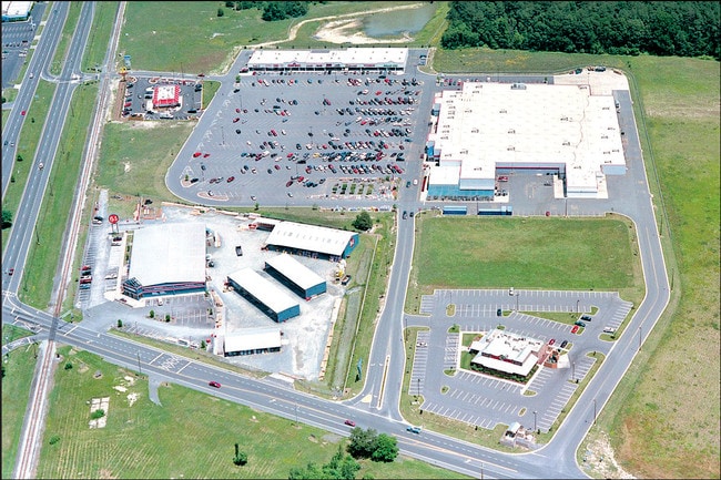
409 N Fruitland Blvd, Salisbury, MD 21801


Property Detail
409 N Fruitland Blvd
16-004286
25.06 AC 409 N FRUITLAND BLVD SOUTHTOWN COMMONS
Wholesaleoutletdiscountstore
Wicomico
I
Maryland
AE The base floodplain where base flood elevations are provided. AE Zones are now used on new format FIRMs instead of A1-A30 Zones.
25.06 AC
2025
Chesapeake Bay/Salisbury
2025
Other Market Areas
010400
Salisbury, MD
7,227 SF
NEARBY LISTINGS FOR SALE OR LEASE
DEMOGRAPHICS near 409 N Fruitland Blvd
1 mile
3 mile
5 mile
2025 Total Population
7,395
39,001
70,136
2030 Population
7,633
39,984
71,785
Pop Growth 2025-2030
+ 3.22%
+ 2.52%
+ 2.35%
Average Age
37
37
38
2025 Total Households
2,690
14,688
26,629
HH Growth 2025-2030
+ 3.31%
+ 2.55%
+ 2.41%
Median Household Inc
$87,024
$64,785
$67,551
Avg Household Size
2.50
2.40
2.50
2025 Avg HH Vehicles
2.00
2.00
2.00
Median Home Value
$269,203
$266,361
$266,015
Median Year Built
1985
1980
1980
Nearby Places
Map Layers
Map Styles
 Street
 Aerial
Layers
 Traffic
 Biking
Places
Listings with unknown addresses are not visible on the map
- Restaurants
- Banks
- Shops
- Fitness
- Groceries
PUBLIC TRANSPORTATION
AIRPORT
Salisbury-Ocean City Wicomico Regional
Drive
Walk
Distance
Salisbury-Ocean City Wicomico Regional
17 min
9.1 mi
Freight Ports
Port of Baltimore
Drive
Walk
Distance
Port of Baltimore
163 min
109.6 mi
SALE & LEASE HISTORY
LISTING DATE
SALE/LEASE

Jun 14, 2022
For Lease
Nearby Properties
Address
Land Use
TOTAL SIZE
Lot Size
Zoning
Address
Land Use
TOTAL SIZE
Lot Size
Zoning
1,792 SF
76.32 AC
R20
Address
Land Use
TOTAL SIZE
Lot Size
Zoning
602,336 SF
22.69 AC
H
Address
Land Use
TOTAL SIZE
Lot Size
Zoning
18,951 SF
35.15 AC
R8
Address
Land Use
TOTAL SIZE
Lot Size
Zoning
151,984 SF
35.30 AC
R4
Address
Land Use
TOTAL SIZE
Lot Size
Zoning
208,457 SF
3.05 AC
C
Address
Land Use
TOTAL SIZE
Lot Size
Zoning
32,100 SF
22.32 AC
LI
Address
Land Use
TOTAL SIZE
Lot Size
Zoning
118,330 SF
1.99 AC
CBD
Address
Land Use
TOTAL SIZE
Lot Size
Zoning
103,992 SF
0.59 AC
CBD
Address
Land Use
TOTAL SIZE
Lot Size
Zoning
160,552 SF
15.48 AC
Address
Land Use
TOTAL SIZE
Lot Size
Zoning
20,850 SF
12.08 AC
CU
Address
Land Use
TOTAL SIZE
Lot Size
Zoning
164,178 SF
55.53 AC
R5A
Address
Land Use
TOTAL SIZE
Lot Size
Zoning
4,093 SF
75.38 AC
R8
Address
Land Use
TOTAL SIZE
Lot Size
Zoning
14,988 SF
7.51 AC
R8A
Address
Land Use
TOTAL SIZE
Lot Size
Zoning
14,614 SF
17.23 AC
R8A
Address
Land Use
TOTAL SIZE
Lot Size
Zoning
12,024 SF
12.98 AC
R5A
Address
Land Use
TOTAL SIZE
Lot Size
Zoning
22,431 SF
8.74 AC
R10
Address
Land Use
TOTAL SIZE
Lot Size
Zoning
3,408 SF
69.67 AC
I
Address
Land Use
TOTAL SIZE
Lot Size
Zoning
19,608 SF
4.99 AC
CU
Address
Land Use
TOTAL SIZE
Lot Size
Zoning
58,528 SF
15.05 AC
R8
Address
Land Use
TOTAL SIZE
Lot Size
Zoning
1,034 SF
18.79 AC
R-8A
Address
Land Use
TOTAL SIZE
Lot Size
Zoning
30,000 SF
20.38 AC
CU
Address
Land Use
TOTAL SIZE
Lot Size
Zoning
64,518 SF
10.20 AC
R12
Address
Land Use
TOTAL SIZE
Lot Size
Zoning
41,473 SF
1.20 AC
CBD
Address
Land Use
TOTAL SIZE
Lot Size
Zoning
195,541 SF
51.98 AC
Address
Land Use
TOTAL SIZE
Lot Size
Zoning
43,164 SF
1.83 AC
CBD
Address
Land Use
TOTAL SIZE
Lot Size
Zoning
37,198 SF
6.15 AC
LI
Address
Land Use
TOTAL SIZE
Lot Size
Zoning
38,424 SF
4.92 AC
R15
Address
Land Use
TOTAL SIZE
Lot Size
Zoning
15,260 SF
13.52 AC
R5A
Address
Land Use
TOTAL SIZE
Lot Size
Zoning
75,556 SF
8.10 AC
R12
Address
Land Use
TOTAL SIZE
Lot Size
Zoning
61,416 SF
0.88 AC
C-4
The World's #1 Commercial Real Estate Marketplace
Connect with us
© 2026 CoStar Group
The information above has been obtained from sources believed reliable. While we do not doubt its accuracy we have not verified it and make no guarantee, warranty or representation about it. It is your responsibility to independently confirm its accuracy and completeness. Any projections, opinions, assumptions, or estimates used are for example only and do not represent the current or future performance of the property. The value of this transaction to you depends on tax and other factors which should be evaluated by your tax, financial, and legal advisors. You and your advisors should conduct a careful, independent investigation of the property to determine to your satisfaction the suitability of the property for your needs.