Property Record
409 Stenton Ave, Flourtown, PA 19031


This Property Is For Sale
NEARBY LISTINGS FOR SALE OR LEASE
Property Detail
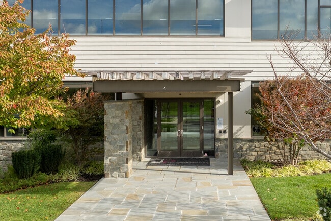
409 Stenton Ave
Philadelphia-Camden-Wilmington, PA-NJ-DE-MD
Reserve At Creekside
65-00-03886-181
ASSESSOR BLOCK-UNIT NUMBER 44C-225
Officebuilding
Montgomery
X
Pennsylvania
42091C0376G
225
2024
3.32 AC
2025
Plymouth Mtg/Blue Bell
203000
Philadelphia
41,940 SF
DEMOGRAPHICS near 409 Stenton Ave
1 Mile
3 Mile
5 Mile
2024 Total Population
1,940
53,112
221,360
2029 Population
2,003
53,909
222,435
Pop Growth 2024-2029
+ 3.25%
+ 1.50%
+ 0.49%
Average Age
47
43
42
2024 Total Households
728
20,447
91,278
HH Growth 2024-2029
+ 3.30%
+ 1.41%
+ 0.31%
Median Household Inc
$196,499
$124,148
$97,905
Avg Household Size
2.60
2.50
2.30
2024 Avg HH Vehicles
2.00
2.00
2.00
Median Home Value
$658,668
$448,908
$366,982
Median Year Built
1981
1965
1960
Nearby Places
Map Layers
Map Styles
 Street
 Aerial
- Restaurants
- Banks
- Shops
- Fitness
- Groceries
PUBLIC TRANSPORTATION
COMMUTER RAIL
Chestnut Hill East (R7 - Southeastern Pennsylvania Transportation Authority Regional Rail (SEPTA Regional Rail))
DRIVE
WALK
Distance
Chestnut Hill East (R7 - Southeastern Pennsylvania Transportation Authority Regional Rail (SEPTA Regional Rail))
6 min
2.8 mi
Fort Washington (R5 - Southeastern Pennsylvania Transportation Authority Regional Rail (SEPTA Regional Rail))
DRIVE
WALK
Distance
Fort Washington (R5 - Southeastern Pennsylvania Transportation Authority Regional Rail (SEPTA Regional Rail))
6 min
3.0 mi
AIRPORT
Philadelphia International
DRIVE
WALK
Distance
Philadelphia International
44 min
28.8 mi
Trenton Mercer
DRIVE
WALK
Distance
Trenton Mercer
48 min
33.7 mi
Freight Ports
Port of Philadelphia
DRIVE
WALK
Distance
Port of Philadelphia
27 min
13.8 mi
Nearby Properties
Address
Land Use
TOTAL SIZE
Lot Size
Zoning
Address
Land Use
TOTAL SIZE
Lot Size
Zoning
952,830 SF
95.86 AC
IAAA
Address
Land Use
TOTAL SIZE
Lot Size
Zoning
733,282 SF
88.07 AC
LIM
Address
Land Use
TOTAL SIZE
Lot Size
Zoning
510,312 SF
51.75 AC
IA
Address
Land Use
TOTAL SIZE
Lot Size
Zoning
469,066 SF
47 AC
MU
Address
Land Use
TOTAL SIZE
Lot Size
Zoning
568,410 SF
33.08 AC
RMX1
Address
Land Use
TOTAL SIZE
Lot Size
Zoning
519,822 SF
19.53 AC
AR
Address
Land Use
TOTAL SIZE
Lot Size
Zoning
467,639 SF
123.58 AC
IAAA
Address
Land Use
TOTAL SIZE
Lot Size
Zoning
415,059 SF
11.59 AC
RSD3
Address
Land Use
TOTAL SIZE
Lot Size
Zoning
211,200 SF
1.46 AC
CMX2
Address
Land Use
TOTAL SIZE
Lot Size
Zoning
57,301 SF
49.77 AC
SPPOA
Address
Land Use
TOTAL SIZE
Lot Size
Zoning
234,934 SF
43.63 AC
AA
Address
Land Use
TOTAL SIZE
Lot Size
Zoning
452,740 SF
11.03 AC
C
Address
Land Use
TOTAL SIZE
Lot Size
Zoning
360,524 SF
59.87 AC
INST
Address
Land Use
TOTAL SIZE
Lot Size
Zoning
512,846 SF
9.50 AC
HRA
Address
Land Use
TOTAL SIZE
Lot Size
Zoning
312,710 SF
30.07 AC
APTLR
Address
Land Use
TOTAL SIZE
Lot Size
Zoning
346,163 SF
16.53 AC
SC
Address
Land Use
TOTAL SIZE
Lot Size
Zoning
190,492 SF
298.37 AC
AR
Address
Land Use
TOTAL SIZE
Lot Size
Zoning
243,979 SF
15.58 AC
IAA
Address
Land Use
TOTAL SIZE
Lot Size
Zoning
86,394 SF
10.26 AC
RSD3
Address
Land Use
TOTAL SIZE
Lot Size
Zoning
227,948 SF
16 AC
AR
Address
Land Use
TOTAL SIZE
Lot Size
Zoning
208,144 SF
13.91 AC
AR
Address
Land Use
TOTAL SIZE
Lot Size
Zoning
186,736 SF
5.39 AC
AR
Address
Land Use
TOTAL SIZE
Lot Size
Zoning
104,810 SF
22.78 AC
MFA
Address
Land Use
TOTAL SIZE
Lot Size
Zoning
747,448 SF
36.04 AC
SC
Address
Land Use
TOTAL SIZE
Lot Size
Zoning
153,544 SF
14.03 AC
I
Address
Land Use
TOTAL SIZE
Lot Size
Zoning
33,631 SF
85.98 AC
RSD1
Address
Land Use
TOTAL SIZE
Lot Size
Zoning
184,881 SF
18.07 AC
APTHR
Address
Land Use
TOTAL SIZE
Lot Size
Zoning
215,084 SF
12.96 AC
PO
Address
Land Use
TOTAL SIZE
Lot Size
Zoning
114,038 SF
13.28 AC
LIM
Address
Land Use
TOTAL SIZE
Lot Size
Zoning
104,501 SF
5.53 AC
LC
The World's #1 Commercial Real Estate Marketplace
Connect with us
© 2025 CoStar Group
The information above has been obtained from sources believed reliable. While we do not doubt its accuracy we have not verified it and make no guarantee, warranty or representation about it. It is your responsibility to independently confirm its accuracy and completeness. Any projections, opinions, assumptions, or estimates used are for example only and do not represent the current or future performance of the property. The value of this transaction to you depends on tax and other factors which should be evaluated by your tax, financial, and legal advisors. You and your advisors should conduct a careful, independent investigation of the property to determine to your satisfaction the suitability of the property for your needs.