Property Record
409 W Jameson Ave, Battle Creek, MI 49014
NEARBY LISTINGS FOR SALE OR LEASE
Property Detail
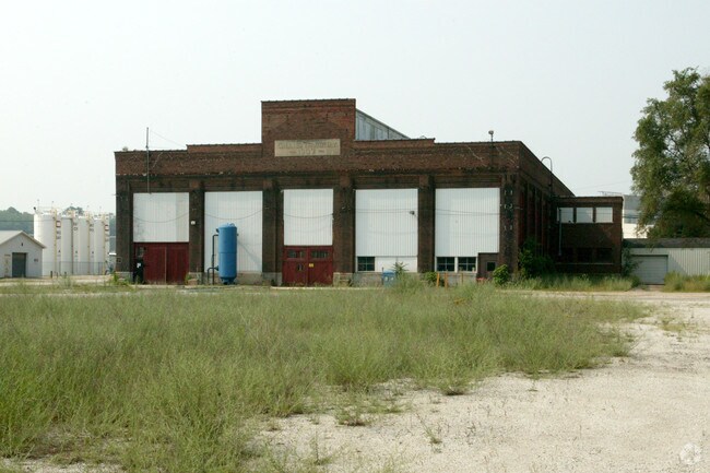
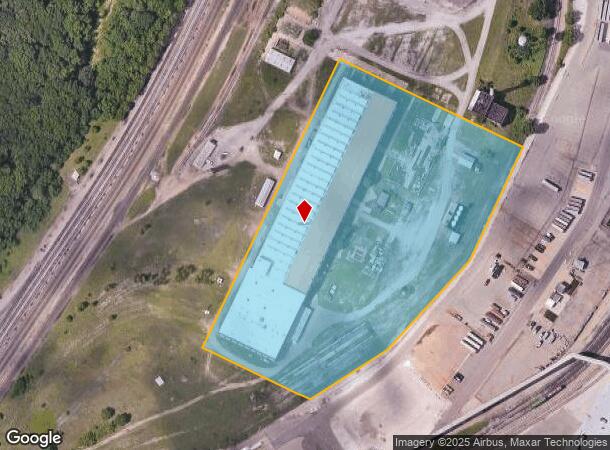
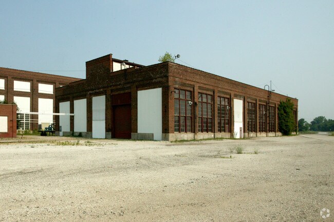
409 W Jameson Ave
0705-46-600-0
Part Of S Of Sd
Warehouse
PART OF S ? OF SD SEC 5 & PART OF N ? OF SEC 8, T2S R7W: COMM S ? POST OF SD SEC 5 ? N 89? 24? 02? W ALG S LI OF SEC 5 DIST
X
Calhoun
26025C0184C
Michigan
0
11.27 AC
2025
Battle Crk/W Calhoun Cnty
000700
West Michigan
150,792 SF
Battle Creek, MI
DEMOGRAPHICS near 409 W Jameson Ave
1 Mile
3 Mile
5 Mile
2024 Total Population
6,378
38,123
67,727
2029 Population
6,381
37,906
67,068
Pop Growth 2024-2029
+ 0.05%
(0.57%)
(0.97%)
Average Age
38
39
40
2024 Total Households
2,442
15,263
27,390
HH Growth 2024-2029
0.00%
(0.64%)
(1.01%)
Median Household Inc
$41,686
$44,393
$51,615
Avg Household Size
2.40
2.40
2.40
2024 Avg HH Vehicles
2.00
2.00
2.00
Median Home Value
$66,308
$92,095
$117,773
Median Year Built
1948
1954
1956
Nearby Places
- Restaurants
- Banks
- Shops
- Fitness
- Groceries
PUBLIC TRANSPORTATION
COMMUTER RAIL
Battle Creek (Blue Water - Amtrak, Wolverine - Amtrak)
DRIVE
WALK
Distance
Battle Creek (Blue Water - Amtrak, Wolverine - Amtrak)
9 min
3.9 mi
AIRPORT
Kalamazoo/Battle Creek International
DRIVE
WALK
Distance
Kalamazoo/Battle Creek International
43 min
29.0 mi
Freight Ports
Port of Toledo
DRIVE
WALK
Distance
Port of Toledo
153 min
122.0 mi
Nearby Properties
Address
Land Use
TOTAL SIZE
Lot Size
Zoning
Address
Land Use
TOTAL SIZE
Lot Size
Zoning
1,513,110 SF
108.07 AC
I2
Address
Land Use
TOTAL SIZE
Lot Size
Zoning
337,297 SF
18.85 AC
T4
Address
Land Use
TOTAL SIZE
Lot Size
Zoning
291,206 SF
18.98 AC
T4
Address
Land Use
TOTAL SIZE
Lot Size
Zoning
1,131,895 SF
26.46 AC
I1
Address
Land Use
TOTAL SIZE
Lot Size
Zoning
324,731 SF
69.91 AC
MF
Address
Land Use
TOTAL SIZE
Lot Size
Zoning
174,064 SF
T4
Address
Land Use
TOTAL SIZE
Lot Size
Zoning
52,764 SF
3.52 AC
AG
Address
Land Use
TOTAL SIZE
Lot Size
Zoning
158,786 SF
22.52 AC
HDR
Address
Land Use
TOTAL SIZE
Lot Size
Zoning
134,482 SF
17.15 AC
MFR
Address
Land Use
TOTAL SIZE
Lot Size
Zoning
129,598 SF
0.62 AC
T5
Address
Land Use
TOTAL SIZE
Lot Size
Zoning
34,452 SF
1.12 AC
T4
Address
Land Use
TOTAL SIZE
Lot Size
Zoning
106,703 SF
9.69 AC
MFR
Address
Land Use
TOTAL SIZE
Lot Size
Zoning
126,060 SF
15.89 AC
MF
Address
Land Use
TOTAL SIZE
Lot Size
Zoning
49,412 SF
Address
Land Use
TOTAL SIZE
Lot Size
Zoning
52,109 SF
6.46 AC
MFR
Address
Land Use
TOTAL SIZE
Lot Size
Zoning
53,501 SF
7.34 AC
B1
Address
Land Use
TOTAL SIZE
Lot Size
Zoning
98,360 SF
0.31 AC
T5
Address
Land Use
TOTAL SIZE
Lot Size
Zoning
82,210 SF
0.29 AC
T5
Address
Land Use
TOTAL SIZE
Lot Size
Zoning
149,939 SF
28.09 AC
I1
Address
Land Use
TOTAL SIZE
Lot Size
Zoning
350,559 SF
18.76 AC
I2
Address
Land Use
TOTAL SIZE
Lot Size
Zoning
45,864 SF
7.84 AC
B1
Address
Land Use
TOTAL SIZE
Lot Size
Zoning
Address
Land Use
TOTAL SIZE
Lot Size
Zoning
394,832 SF
48.36 AC
I1
Address
Land Use
TOTAL SIZE
Lot Size
Zoning
32,729 SF
3.56 AC
B1
Address
Land Use
TOTAL SIZE
Lot Size
Zoning
60,544 SF
5.96 AC
HDR
Address
Land Use
TOTAL SIZE
Lot Size
Zoning
263,389 SF
13.23 AC
I1
Address
Land Use
TOTAL SIZE
Lot Size
Zoning
418,170 SF
12.38 AC
T4
Address
Land Use
TOTAL SIZE
Lot Size
Zoning
141,239 SF
6.90 AC
I1
Address
Land Use
TOTAL SIZE
Lot Size
Zoning
46,711 SF
4.99 AC
B1
Address
Land Use
TOTAL SIZE
Lot Size
Zoning
48,192 SF
1.86 AC
T3
The World's #1 Commercial Real Estate Marketplace
Connect with us
© 2025 CoStar Group
The information above has been obtained from sources believed reliable. While we do not doubt its accuracy we have not verified it and make no guarantee, warranty or representation about it. It is your responsibility to independently confirm its accuracy and completeness. Any projections, opinions, assumptions, or estimates used are for example only and do not represent the current or future performance of the property. The value of this transaction to you depends on tax and other factors which should be evaluated by your tax, financial, and legal advisors. You and your advisors should conduct a careful, independent investigation of the property to determine to your satisfaction the suitability of the property for your needs.