Property Record
4090 Jeffrey Blvd, Buffalo, NY 14219
NEARBY LISTINGS FOR SALE OR LEASE
Property Detail
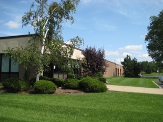
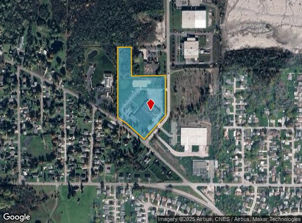
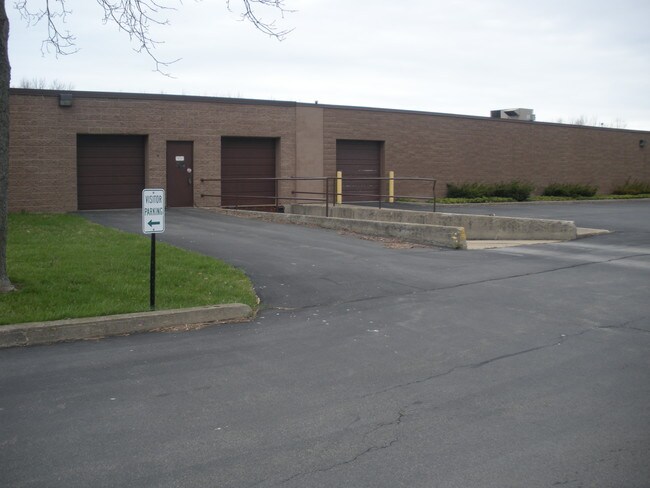
4090 Jeffrey Blvd
144889-159-160-0001-004-100
Holland Land Companys Survey
Manufacturinglight
Erie
X
New York
36029C0339H
4.100
2025
8.90 AC
2024
South
013001
Buffalo/Niagara Falls
53,732 SF
Buffalo-Cheektowaga-Niagara Falls, NY
DEMOGRAPHICS near 4090 Jeffrey Blvd
1 Mile
3 Mile
5 Mile
2024 Total Population
6,130
43,451
107,263
2029 Population
6,140
43,399
106,743
Pop Growth 2024-2029
+ 0.16%
(0.12%)
(0.48%)
Average Age
47
44
43
2024 Total Households
2,749
19,564
46,417
HH Growth 2024-2029
+ 0.07%
(0.22%)
(0.58%)
Median Household Inc
$65,578
$63,008
$68,418
Avg Household Size
2.10
2.10
2.20
2024 Avg HH Vehicles
2.00
2.00
2.00
Median Home Value
$163,736
$181,577
$196,124
Median Year Built
1981
1971
1962
Nearby Places
- Restaurants
- Banks
- Shops
- Fitness
- Groceries
PUBLIC TRANSPORTATION
COMMUTER RAIL
Buffalo (Exchange) (Empire Service - Amtrak, Maple Leaf - Amtrak, Toronto - New York - Amtrak)
DRIVE
WALK
Distance
Buffalo (Exchange) (Empire Service - Amtrak, Maple Leaf - Amtrak, Toronto - New York - Amtrak)
16 min
9.4 mi
AIRPORT
Buffalo Niagara International
DRIVE
WALK
Distance
Buffalo Niagara International
28 min
17.3 mi
Niagara Falls International
DRIVE
WALK
Distance
Niagara Falls International
44 min
28.7 mi
Freight Ports
Port of Toledo
DRIVE
WALK
Distance
Port of Toledo
348 min
295.3 mi
Nearby Properties
Address
Land Use
TOTAL SIZE
Lot Size
Zoning
Address
Land Use
TOTAL SIZE
Lot Size
Zoning
49,500 SF
108.40 AC
R1
Address
Land Use
TOTAL SIZE
Lot Size
Zoning
42.90 AC
M1
Address
Land Use
TOTAL SIZE
Lot Size
Zoning
14,835 SF
215.22 AC
C2
Address
Land Use
TOTAL SIZE
Lot Size
Zoning
22,754 SF
41.80 AC
Address
Land Use
TOTAL SIZE
Lot Size
Zoning
184,188 SF
110.75 AC
Address
Land Use
TOTAL SIZE
Lot Size
Zoning
77,270 SF
46.15 AC
C3
Address
Land Use
TOTAL SIZE
Lot Size
Zoning
337,198 SF
51.05 AC
M1
Address
Land Use
TOTAL SIZE
Lot Size
Zoning
197,584 SF
32.50 AC
B2
Address
Land Use
TOTAL SIZE
Lot Size
Zoning
80,440 SF
1.54 AC
N-1C
Address
Land Use
TOTAL SIZE
Lot Size
Zoning
18,840 SF
114.12 AC
M3
Address
Land Use
TOTAL SIZE
Lot Size
Zoning
151,200 SF
8.36 AC
BETH
Address
Land Use
TOTAL SIZE
Lot Size
Zoning
118,358 SF
59.67 AC
Address
Land Use
TOTAL SIZE
Lot Size
Zoning
110,150 SF
39.23 AC
IND
Address
Land Use
TOTAL SIZE
Lot Size
Zoning
9.91 AC
IND
Address
Land Use
TOTAL SIZE
Lot Size
Zoning
218,461 SF
27.59 AC
C2
Address
Land Use
TOTAL SIZE
Lot Size
Zoning
34,888 SF
29 AC
C1
Address
Land Use
TOTAL SIZE
Lot Size
Zoning
91,618 SF
11.30 AC
Address
Land Use
TOTAL SIZE
Lot Size
Zoning
165,478 SF
9.79 AC
Address
Land Use
TOTAL SIZE
Lot Size
Zoning
10,486 SF
25.30 AC
R3
Address
Land Use
TOTAL SIZE
Lot Size
Zoning
86.94 AC
R4
Address
Land Use
TOTAL SIZE
Lot Size
Zoning
28,578 SF
10.46 AC
C1
Address
Land Use
TOTAL SIZE
Lot Size
Zoning
221,896 SF
21.50 AC
Address
Land Use
TOTAL SIZE
Lot Size
Zoning
8,320 SF
22.10 AC
Address
Land Use
TOTAL SIZE
Lot Size
Zoning
5,600 SF
106.10 AC
PR
Address
Land Use
TOTAL SIZE
Lot Size
Zoning
181,500 SF
58 AC
M3P
Address
Land Use
TOTAL SIZE
Lot Size
Zoning
103,215 SF
6.14 AC
C1
Address
Land Use
TOTAL SIZE
Lot Size
Zoning
8,352 SF
27.62 AC
R3
Address
Land Use
TOTAL SIZE
Lot Size
Zoning
102,037 SF
9.95 AC
C2
Address
Land Use
TOTAL SIZE
Lot Size
Zoning
13,062 SF
26.07 AC
R4
Address
Land Use
TOTAL SIZE
Lot Size
Zoning
111,225 SF
10.52 AC
C2
The World's #1 Commercial Real Estate Marketplace
Connect with us
© 2025 CoStar Group
The information above has been obtained from sources believed reliable. While we do not doubt its accuracy we have not verified it and make no guarantee, warranty or representation about it. It is your responsibility to independently confirm its accuracy and completeness. Any projections, opinions, assumptions, or estimates used are for example only and do not represent the current or future performance of the property. The value of this transaction to you depends on tax and other factors which should be evaluated by your tax, financial, and legal advisors. You and your advisors should conduct a careful, independent investigation of the property to determine to your satisfaction the suitability of the property for your needs.