Property Record
4092 S Mccall Rd, Englewood, FL 34224
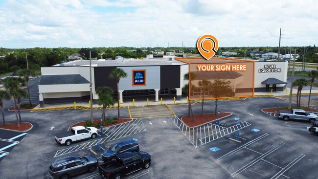
Current Lease Availabilities
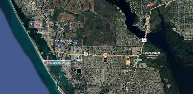
NEARBY LISTINGS FOR SALE OR LEASE
Property Detail
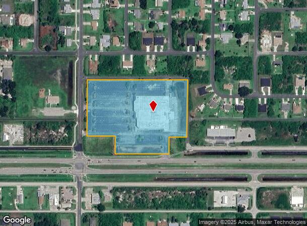
4092 S Mccall Rd
412001352001
Port Charlotte
Supermarket
PORT CHARLOTTE SEC 63 BLK 3697 A PORTION OF TRACT K DESC AS BEG AT NW COR OF TR K TH E 695.35 FT S 393.35 FT W 125 FT S 117.01 FT W 375.20 FT N 123.01 FT W 195.01 FT N 387.35 FT TO POB 1338/1925 E1343/2174 E1409/97 1422/437 1504/578 1506/1647 E1600/1
X
Charlotte
12015C0192G
Florida
2024
7.16 AC
2025
Charlotte County
030202
Southwest Florida
56,171 SF
Punta Gorda, FL
DEMOGRAPHICS near 4092 S Mccall Rd
1 Mile
3 Mile
5 Mile
2024 Total Population
4,357
26,634
55,244
2029 Population
5,189
32,148
67,088
Pop Growth 2024-2029
+ 19.10%
+ 20.70%
+ 21.44%
Average Age
49
55
57
2024 Total Households
1,953
12,626
26,803
HH Growth 2024-2029
+ 19.20%
+ 20.93%
+ 21.66%
Median Household Inc
$59,292
$56,217
$58,783
Avg Household Size
2.20
2.10
2.00
2024 Avg HH Vehicles
2.00
2.00
2.00
Median Home Value
$225,138
$248,851
$271,253
Median Year Built
1991
1993
1993
Nearby Places
Map Layers
Map Styles
 Street
 Aerial
- Restaurants
- Banks
- Shops
- Fitness
- Groceries
PUBLIC TRANSPORTATION
AIRPORT
Punta Gorda
DRIVE
WALK
Distance
Punta Gorda
40 min
23.5 mi
Nearby Properties
Address
Land Use
TOTAL SIZE
Lot Size
Zoning
Address
Land Use
TOTAL SIZE
Lot Size
Zoning
193,100 SF
26.30 AC
PD
Address
Land Use
TOTAL SIZE
Lot Size
Zoning
28,490 SF
172 AC
PKR
Address
Land Use
TOTAL SIZE
Lot Size
Zoning
91,934 SF
8.39 AC
PD
Address
Land Use
TOTAL SIZE
Lot Size
Zoning
107,736 SF
35.90 AC
RMF5
Address
Land Use
TOTAL SIZE
Lot Size
Zoning
99,840 SF
7.60 AC
IG
Address
Land Use
TOTAL SIZE
Lot Size
Zoning
67,466 SF
16.30 AC
CG
Address
Land Use
TOTAL SIZE
Lot Size
Zoning
27.65 AC
RMF15
Address
Land Use
TOTAL SIZE
Lot Size
Zoning
58,185 SF
3.40 AC
IG
Address
Land Use
TOTAL SIZE
Lot Size
Zoning
108,048 SF
14.84 AC
CG
Address
Land Use
TOTAL SIZE
Lot Size
Zoning
25,777 SF
12.18 AC
PD
Address
Land Use
TOTAL SIZE
Lot Size
Zoning
132.79 AC
PKR
Address
Land Use
TOTAL SIZE
Lot Size
Zoning
25,478 SF
11.06 AC
IG
Address
Land Use
TOTAL SIZE
Lot Size
Zoning
100,910 SF
22.85 AC
RSF3.5
Address
Land Use
TOTAL SIZE
Lot Size
Zoning
106,737 SF
20.80 AC
RMF5
Address
Land Use
TOTAL SIZE
Lot Size
Zoning
34.11 AC
CG
Address
Land Use
TOTAL SIZE
Lot Size
Zoning
33,047 SF
10.17 AC
PKR
Address
Land Use
TOTAL SIZE
Lot Size
Zoning
25,568 SF
2.73 AC
CG
Address
Land Use
TOTAL SIZE
Lot Size
Zoning
20.12 AC
CG
Address
Land Use
TOTAL SIZE
Lot Size
Zoning
24,708 SF
14.89 AC
CT
Address
Land Use
TOTAL SIZE
Lot Size
Zoning
38.14 AC
IG
Address
Land Use
TOTAL SIZE
Lot Size
Zoning
14,200 SF
2.26 AC
IG
Address
Land Use
TOTAL SIZE
Lot Size
Zoning
12,300 SF
5.02 AC
IG
Address
Land Use
TOTAL SIZE
Lot Size
Zoning
38.60 AC
PD
Address
Land Use
TOTAL SIZE
Lot Size
Zoning
26,248 SF
6.32 AC
PD
Address
Land Use
TOTAL SIZE
Lot Size
Zoning
11,509 SF
12.06 AC
RSF3.5
Address
Land Use
TOTAL SIZE
Lot Size
Zoning
14,482 SF
1.89 AC
CG
Address
Land Use
TOTAL SIZE
Lot Size
Zoning
15,190 SF
154.40 AC
RSF5
Address
Land Use
TOTAL SIZE
Lot Size
Zoning
21,180 SF
2.91 AC
CG
The World's #1 Commercial Real Estate Marketplace
Connect with us
© 2025 CoStar Group
The information above has been obtained from sources believed reliable. While we do not doubt its accuracy we have not verified it and make no guarantee, warranty or representation about it. It is your responsibility to independently confirm its accuracy and completeness. Any projections, opinions, assumptions, or estimates used are for example only and do not represent the current or future performance of the property. The value of this transaction to you depends on tax and other factors which should be evaluated by your tax, financial, and legal advisors. You and your advisors should conduct a careful, independent investigation of the property to determine to your satisfaction the suitability of the property for your needs.