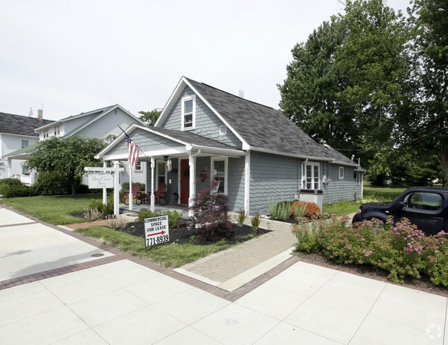
Property Record
4095 Main St, Hilliard, OH 43026


NEARBY LISTINGS FOR SALE OR LEASE
Property Detail
4095 Main St
Columbus
Incorporation Plat Of Hilliard
Columbus, OH
4095 MAIN ST CITY OF HILLIARD LOT 144 EX 3SS
050-000153
Franklin
Storemultistory
Ohio
2024
144
2025
0.16 AC
007962
Hilliard
783 SF
DEMOGRAPHICS near 4095 Main St
1 mile
3 mile
5 mile
2024 Total Population
11,665
80,540
163,232
2029 Population
11,614
79,805
162,311
Pop Growth 2024-2029
(0.44%)
(0.91%)
(0.56%)
Average Age
39
37
38
2024 Total Households
4,779
33,100
67,636
HH Growth 2024-2029
(0.31%)
(0.92%)
(0.58%)
Median Household Inc
$84,900
$90,998
$91,654
Avg Household Size
2.40
2.40
2.40
2024 Avg HH Vehicles
2.00
2.00
2.00
Median Home Value
$255,067
$279,394
$298,580
Median Year Built
1989
1996
1992
Nearby Places
Map Layers
Map Styles
 Street
 Aerial
Transit
 Traffic
 Biking
Places
Listings with unknown addresses are not visible on the map
- Restaurants
- Banks
- Shops
- Fitness
- Groceries
PUBLIC TRANSPORTATION
AIRPORT
John Glenn Columbus International
Drive
Walk
Distance
John Glenn Columbus International
29 min
19.8 mi
Rickenbacker International
Drive
Walk
Distance
Rickenbacker International
34 min
24.4 mi
Nearby Properties
Address
Land Use
TOTAL SIZE
Lot Size
Zoning
Address
Land Use
TOTAL SIZE
Lot Size
Zoning
768,498 SF
55.17 AC
Address
Land Use
TOTAL SIZE
Lot Size
Zoning
880,352 SF
94.89 AC
Address
Land Use
TOTAL SIZE
Lot Size
Zoning
327,525 SF
70.58 AC
Address
Land Use
TOTAL SIZE
Lot Size
Zoning
529,001 SF
0.15 AC
Address
Land Use
TOTAL SIZE
Lot Size
Zoning
549,907 SF
35.81 AC
Address
Land Use
TOTAL SIZE
Lot Size
Zoning
133,910 SF
14.48 AC
Address
Land Use
TOTAL SIZE
Lot Size
Zoning
158,471 SF
19.11 AC
Address
Land Use
TOTAL SIZE
Lot Size
Zoning
46,231 SF
27.42 AC
Address
Land Use
TOTAL SIZE
Lot Size
Zoning
91,413 SF
0.14 AC
Address
Land Use
TOTAL SIZE
Lot Size
Zoning
47,334 SF
29.34 AC
Address
Land Use
TOTAL SIZE
Lot Size
Zoning
195,867 SF
14.13 AC
Address
Land Use
TOTAL SIZE
Lot Size
Zoning
110,180 SF
29.07 AC
Address
Land Use
TOTAL SIZE
Lot Size
Zoning
446,488 SF
45.12 AC
Address
Land Use
TOTAL SIZE
Lot Size
Zoning
179,820 SF
11.69 AC
Address
Land Use
TOTAL SIZE
Lot Size
Zoning
163,895 SF
36.52 AC
Address
Land Use
TOTAL SIZE
Lot Size
Zoning
276,379 SF
14.75 AC
Address
Land Use
TOTAL SIZE
Lot Size
Zoning
111,934 SF
11.90 AC
Address
Land Use
TOTAL SIZE
Lot Size
Zoning
67,186 SF
21.51 AC
Address
Land Use
TOTAL SIZE
Lot Size
Zoning
226,566 SF
14.88 AC
Address
Land Use
TOTAL SIZE
Lot Size
Zoning
105,351 SF
9.88 AC
Address
Land Use
TOTAL SIZE
Lot Size
Zoning
98,316 SF
10.81 AC
Address
Land Use
TOTAL SIZE
Lot Size
Zoning
40,500 SF
20.91 AC
Address
Land Use
TOTAL SIZE
Lot Size
Zoning
156,030 SF
31.29 AC
Address
Land Use
TOTAL SIZE
Lot Size
Zoning
21,238 SF
14.67 AC
Address
Land Use
TOTAL SIZE
Lot Size
Zoning
86,067 SF
14.79 AC
Address
Land Use
TOTAL SIZE
Lot Size
Zoning
67,192 SF
17.70 AC
Address
Land Use
TOTAL SIZE
Lot Size
Zoning
149,424 SF
39.15 AC
Address
Land Use
TOTAL SIZE
Lot Size
Zoning
103,881 SF
11.78 AC
Address
Land Use
TOTAL SIZE
Lot Size
Zoning
33,512 SF
0.18 AC
Address
Land Use
TOTAL SIZE
Lot Size
Zoning
126,656 SF
15.83 AC
The World's #1 Commercial Real Estate Marketplace
Connect with us
© 2026 CoStar Group
The information above has been obtained from sources believed reliable. While we do not doubt its accuracy we have not verified it and make no guarantee, warranty or representation about it. It is your responsibility to independently confirm its accuracy and completeness. Any projections, opinions, assumptions, or estimates used are for example only and do not represent the current or future performance of the property. The value of this transaction to you depends on tax and other factors which should be evaluated by your tax, financial, and legal advisors. You and your advisors should conduct a careful, independent investigation of the property to determine to your satisfaction the suitability of the property for your needs.