Property Record
4095 Round Bottom Rd, Cincinnati, OH 45244


Property Detail
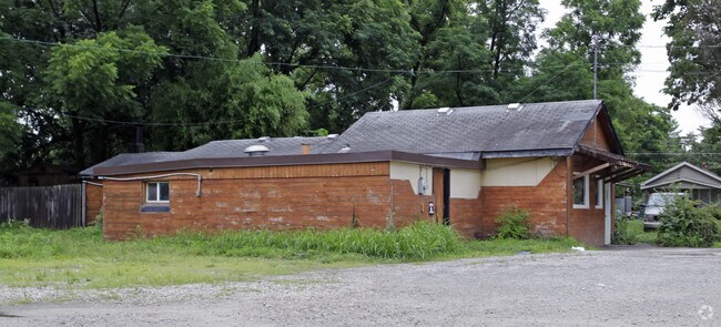
4095 Round Bottom Rd
500-0171-0093
ROUND BOTTOM RD 217.66 X 356.95 IRR PT FARM #6 U S GOVT PROP SUB
Restaurantbuilding
Hamilton
AE The base floodplain where base flood elevations are provided. AE Zones are now used on new format FIRMs instead of A1-A30 Zones.
Ohio
2025
1.29 AC
2025
Milford/Wards Corner
024901
Cincinnati/Dayton
2,107 SF
Cincinnati, OH-KY-IN
NEARBY LISTINGS FOR SALE OR LEASE
DEMOGRAPHICS near 4095 Round Bottom Rd
1 mile
3 mile
5 mile
2025 Total Population
1,110
31,930
128,510
2030 Population
1,123
32,306
129,961
Pop Growth 2025-2030
+ 1.17%
+ 1.18%
+ 1.13%
Average Age
40
41
41
2025 Total Households
413
12,542
53,989
HH Growth 2025-2030
+ 0.97%
+ 1.44%
+ 1.30%
Median Household Inc
$65,921
$101,724
$90,111
Avg Household Size
2.60
2.50
2.30
2025 Avg HH Vehicles
2.00
2.00
2.00
Median Home Value
$837,719
$427,287
$340,103
Median Year Built
1973
1969
1969
Nearby Places
Map Layers
Map Styles
 Street
 Aerial
Transit
 Traffic
 Biking
Places
Listings with unknown addresses are not visible on the map
- Restaurants
- Banks
- Shops
- Fitness
- Groceries
PUBLIC TRANSPORTATION
AIRPORT
Cincinnati/Northern Kentucky International
Drive
Walk
Distance
Cincinnati/Northern Kentucky International
49 min
30.2 mi
Nearby Properties
Address
Land Use
TOTAL SIZE
Lot Size
Zoning
Address
Land Use
TOTAL SIZE
Lot Size
Zoning
20.01 AC
Address
Land Use
TOTAL SIZE
Lot Size
Zoning
1,205 SF
41.47 AC
Address
Land Use
TOTAL SIZE
Lot Size
Zoning
25.51 AC
Address
Land Use
TOTAL SIZE
Lot Size
Zoning
20.38 AC
Address
Land Use
TOTAL SIZE
Lot Size
Zoning
49.27 AC
Address
Land Use
TOTAL SIZE
Lot Size
Zoning
1,134,029 SF
229.73 AC
Address
Land Use
TOTAL SIZE
Lot Size
Zoning
7.49 AC
Address
Land Use
TOTAL SIZE
Lot Size
Zoning
28.27 AC
Address
Land Use
TOTAL SIZE
Lot Size
Zoning
6.55 AC
Address
Land Use
TOTAL SIZE
Lot Size
Zoning
55,848 SF
12.51 AC
Address
Land Use
TOTAL SIZE
Lot Size
Zoning
49.66 AC
Address
Land Use
TOTAL SIZE
Lot Size
Zoning
62,823 SF
8.24 AC
Address
Land Use
TOTAL SIZE
Lot Size
Zoning
9.59 AC
Address
Land Use
TOTAL SIZE
Lot Size
Zoning
Address
Land Use
TOTAL SIZE
Lot Size
Zoning
13.89 AC
Address
Land Use
TOTAL SIZE
Lot Size
Zoning
19,843 SF
4 AC
Address
Land Use
TOTAL SIZE
Lot Size
Zoning
140.32 AC
Address
Land Use
TOTAL SIZE
Lot Size
Zoning
75,974 SF
10.53 AC
Address
Land Use
TOTAL SIZE
Lot Size
Zoning
102,891 SF
20.87 AC
Address
Land Use
TOTAL SIZE
Lot Size
Zoning
Address
Land Use
TOTAL SIZE
Lot Size
Zoning
15,560 SF
37.03 AC
Address
Land Use
TOTAL SIZE
Lot Size
Zoning
14,223 SF
7.22 AC
Address
Land Use
TOTAL SIZE
Lot Size
Zoning
27,957 SF
29.54 AC
Address
Land Use
TOTAL SIZE
Lot Size
Zoning
14.28 AC
DD
Address
Land Use
TOTAL SIZE
Lot Size
Zoning
3,282 SF
1.47 AC
B
Address
Land Use
TOTAL SIZE
Lot Size
Zoning
70.36 AC
A
Address
Land Use
TOTAL SIZE
Lot Size
Zoning
17,485 SF
24.29 AC
Address
Land Use
TOTAL SIZE
Lot Size
Zoning
5.97 AC
EPUDSPI
Address
Land Use
TOTAL SIZE
Lot Size
Zoning
7.45 AC
Address
Land Use
TOTAL SIZE
Lot Size
Zoning
39,257 SF
11.54 AC
The World's #1 Commercial Real Estate Marketplace
Connect with us
© 2026 CoStar Group
The information above has been obtained from sources believed reliable. While we do not doubt its accuracy we have not verified it and make no guarantee, warranty or representation about it. It is your responsibility to independently confirm its accuracy and completeness. Any projections, opinions, assumptions, or estimates used are for example only and do not represent the current or future performance of the property. The value of this transaction to you depends on tax and other factors which should be evaluated by your tax, financial, and legal advisors. You and your advisors should conduct a careful, independent investigation of the property to determine to your satisfaction the suitability of the property for your needs.