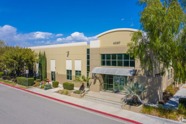
Property Record
4097 Trail Creek Rd, Riverside, CA 92505


Current Lease Availabilities
NEARBY LISTINGS FOR SALE OR LEASE
Property Detail
4097 Trail Creek Rd
Riverside-San Bernardino-Ontario, CA
Parcel Map No 31164
142-090-042
.81 ACRES NET IN PAR 23 PM 205/030 PM 31164
Lightindustrial
Riverside
X
California
06065C0715G
23
2024
0.81 AC
2025
Riverside
041406
Inland Empire (California)
13,600 SF
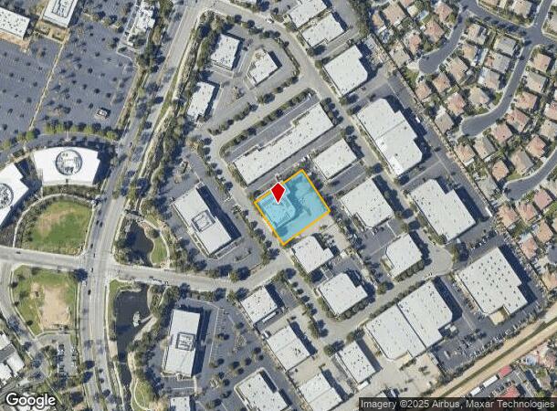
DEMOGRAPHICS near 4097 Trail Creek Rd
1 Mile
3 Mile
5 Mile
2024 Total Population
22,525
120,562
248,076
2029 Population
23,624
126,501
260,595
Pop Growth 2024-2029
+ 4.88%
+ 4.93%
+ 5.05%
Average Age
36
36
36
2024 Total Households
7,180
34,402
70,355
HH Growth 2024-2029
+ 4.46%
+ 4.47%
+ 4.61%
Median Household Inc
$75,369
$83,109
$81,606
Avg Household Size
3.00
3.30
3.30
2024 Avg HH Vehicles
2.00
2.00
2.00
Median Home Value
$462,810
$497,794
$493,300
Median Year Built
1988
1984
1980
Nearby Places
Map Layers
Map Styles
 Street
 Aerial
- Restaurants
- Banks
- Shops
- Fitness
- Groceries
PUBLIC TRANSPORTATION
COMMUTER RAIL
Riverside-La Sierra (91 Line - Southern California Regional Rail Authority (Metrolink), Inland Empire-Orange County Line - Southern California Regional Rail Authority (Metrolink))
DRIVE
WALK
Distance
Riverside-La Sierra (91 Line - Southern California Regional Rail Authority (Metrolink), Inland Empire-Orange County Line - Southern California Regional Rail Authority (Metrolink))
5 min
2.2 mi
North Main Corona (91 Line - Southern California Regional Rail Authority (Metrolink), Inland Empire-Orange County Line - Southern California Regional Rail Authority (Metrolink))
DRIVE
WALK
Distance
North Main Corona (91 Line - Southern California Regional Rail Authority (Metrolink), Inland Empire-Orange County Line - Southern California Regional Rail Authority (Metrolink))
8 min
5.3 mi
AIRPORT
Ontario International
DRIVE
WALK
Distance
Ontario International
27 min
19.4 mi
John Wayne/Orange County
DRIVE
WALK
Distance
John Wayne/Orange County
41 min
33.1 mi
Freight Ports
Port of Long Beach
DRIVE
WALK
Distance
Port of Long Beach
62 min
47.1 mi
Nearby Properties
Address
Land Use
TOTAL SIZE
Lot Size
Zoning
Address
Land Use
TOTAL SIZE
Lot Size
Zoning
1,658,755 SF
37.05 AC
Address
Land Use
TOTAL SIZE
Lot Size
Zoning
263,807 SF
13.14 AC
Address
Land Use
TOTAL SIZE
Lot Size
Zoning
167,068 SF
26.55 AC
Address
Land Use
TOTAL SIZE
Lot Size
Zoning
32,924 SF
24.04 AC
Address
Land Use
TOTAL SIZE
Lot Size
Zoning
76,546 SF
13.53 AC
R
Address
Land Use
TOTAL SIZE
Lot Size
Zoning
335,820 SF
15.18 AC
Address
Land Use
TOTAL SIZE
Lot Size
Zoning
71,440 SF
14.37 AC
Address
Land Use
TOTAL SIZE
Lot Size
Zoning
152,369 SF
5.38 AC
Address
Land Use
TOTAL SIZE
Lot Size
Zoning
20.08 AC
R020
Address
Land Use
TOTAL SIZE
Lot Size
Zoning
27,916 SF
8.50 AC
R3
Address
Land Use
TOTAL SIZE
Lot Size
Zoning
46,694 SF
7.16 AC
Address
Land Use
TOTAL SIZE
Lot Size
Zoning
14 AC
R1
Address
Land Use
TOTAL SIZE
Lot Size
Zoning
359,304 SF
8.86 AC
R3
Address
Land Use
TOTAL SIZE
Lot Size
Zoning
52,928 SF
9.69 AC
Address
Land Use
TOTAL SIZE
Lot Size
Zoning
25,808 SF
6.21 AC
Address
Land Use
TOTAL SIZE
Lot Size
Zoning
4,562 SF
6.42 AC
Address
Land Use
TOTAL SIZE
Lot Size
Zoning
129,911 SF
6.10 AC
Address
Land Use
TOTAL SIZE
Lot Size
Zoning
116,787 SF
2.37 AC
Address
Land Use
TOTAL SIZE
Lot Size
Zoning
156,599 SF
6.27 AC
Address
Land Use
TOTAL SIZE
Lot Size
Zoning
196,470 SF
11.43 AC
M1
Address
Land Use
TOTAL SIZE
Lot Size
Zoning
7.56 AC
R3
Address
Land Use
TOTAL SIZE
Lot Size
Zoning
100,000 SF
4.76 AC
CR
Address
Land Use
TOTAL SIZE
Lot Size
Zoning
88,402 SF
2.03 AC
Address
Land Use
TOTAL SIZE
Lot Size
Zoning
96,543 SF
3.34 AC
Address
Land Use
TOTAL SIZE
Lot Size
Zoning
100,000 SF
4.49 AC
CR
Address
Land Use
TOTAL SIZE
Lot Size
Zoning
39,232 SF
8.24 AC
Address
Land Use
TOTAL SIZE
Lot Size
Zoning
163,056 SF
8.43 AC
Address
Land Use
TOTAL SIZE
Lot Size
Zoning
142,039 SF
0.61 AC
M2
Address
Land Use
TOTAL SIZE
Lot Size
Zoning
73,867 SF
4.09 AC
The World's #1 Commercial Real Estate Marketplace
Connect with us
© 2026 CoStar Group
The information above has been obtained from sources believed reliable. While we do not doubt its accuracy we have not verified it and make no guarantee, warranty or representation about it. It is your responsibility to independently confirm its accuracy and completeness. Any projections, opinions, assumptions, or estimates used are for example only and do not represent the current or future performance of the property. The value of this transaction to you depends on tax and other factors which should be evaluated by your tax, financial, and legal advisors. You and your advisors should conduct a careful, independent investigation of the property to determine to your satisfaction the suitability of the property for your needs.