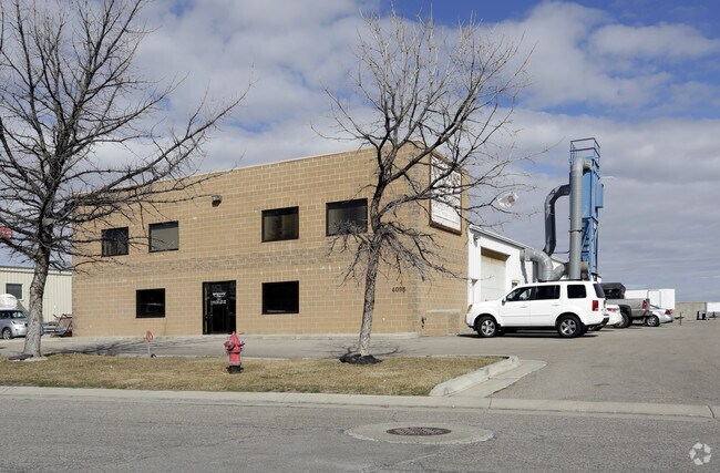
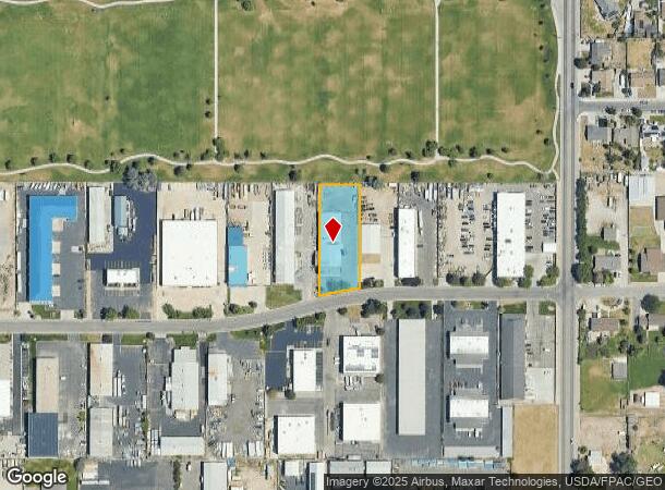
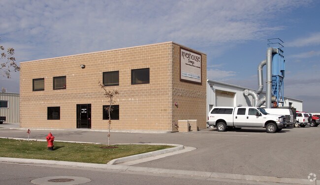
Property Record
4098 W Nike Dr, West Jordan, UT 84088
NEARBY LISTINGS FOR SALE OR LEASE
Property Detail
4098 W Nike Dr
Salt Lake City, UT
Jordan Industrial Center Phase 2
21-31-427-005-0000
LOT 221, JORDAN INDUSTRIAL CENTER PHASE 2. 7531-2647 7809-0169 7846-0001
Lightindustrial
Salt Lake
X
Utah
49035C0430G
221
2024
0.74 AC
2025
West Jordan
113101
Salt Lake City
10,080 SF
DEMOGRAPHICS near 4098 W Nike Dr
1 Mile
3 Mile
5 Mile
2024 Total Population
9,197
128,475
324,384
2029 Population
9,269
130,253
330,078
Pop Growth 2024-2029
+ 0.78%
+ 1.38%
+ 1.76%
Average Age
36
36
35
2024 Total Households
2,632
38,040
98,489
HH Growth 2024-2029
+ 0.65%
+ 1.30%
+ 1.71%
Median Household Inc
$87,015
$93,922
$90,031
Avg Household Size
3.40
3.30
3.20
2024 Avg HH Vehicles
2.00
2.00
2.00
Median Home Value
$391,319
$417,121
$424,431
Median Year Built
1991
1994
1996
Nearby Places
Map Layers
Map Styles
 Street
 Aerial
- Restaurants
- Banks
- Shops
- Fitness
- Groceries
PUBLIC TRANSPORTATION
COMMUTER RAIL
DRIVE
WALK
Distance
15 min
7.1 mi
AIRPORT
Salt Lake City International
DRIVE
WALK
Distance
Salt Lake City International
22 min
13.5 mi
Provo Municipal
DRIVE
WALK
Distance
Provo Municipal
50 min
39.4 mi
Nearby Properties
Address
Land Use
TOTAL SIZE
Lot Size
Zoning
Address
Land Use
TOTAL SIZE
Lot Size
Zoning
733,215 SF
58.65 AC
M-1
Address
Land Use
TOTAL SIZE
Lot Size
Zoning
338,177 SF
21.91 AC
M-1
Address
Land Use
TOTAL SIZE
Lot Size
Zoning
895,175 SF
28.95 AC
SSD-X
Address
Land Use
TOTAL SIZE
Lot Size
Zoning
233,853 SF
6.05 AC
HFR
Address
Land Use
TOTAL SIZE
Lot Size
Zoning
198,801 SF
8.36 AC
R-3-20
Address
Land Use
TOTAL SIZE
Lot Size
Zoning
308,722 SF
21.29 AC
M-1
Address
Land Use
TOTAL SIZE
Lot Size
Zoning
187.81 AC
P-F
Address
Land Use
TOTAL SIZE
Lot Size
Zoning
362,000 SF
51.81 AC
P-F
Address
Land Use
TOTAL SIZE
Lot Size
Zoning
308,722 SF
20.45 AC
M-1
Address
Land Use
TOTAL SIZE
Lot Size
Zoning
256,167 SF
13.56 AC
P-C
Address
Land Use
TOTAL SIZE
Lot Size
Zoning
410,435 SF
2.43 AC
P-C
Address
Land Use
TOTAL SIZE
Lot Size
Zoning
256,933 SF
19.68 AC
P-C
Address
Land Use
TOTAL SIZE
Lot Size
Zoning
77,525 SF
2.35 AC
P-C
Address
Land Use
TOTAL SIZE
Lot Size
Zoning
114.79 AC
PF
Address
Land Use
TOTAL SIZE
Lot Size
Zoning
143,314 SF
2.30 AC
P-C
Address
Land Use
TOTAL SIZE
Lot Size
Zoning
425,753 SF
2.28 AC
PC
Address
Land Use
TOTAL SIZE
Lot Size
Zoning
28,515 SF
6.77 AC
PC
Address
Land Use
TOTAL SIZE
Lot Size
Zoning
187,717 SF
15.02 AC
R-M
Address
Land Use
TOTAL SIZE
Lot Size
Zoning
536,706 SF
12.80 AC
SC-2
Address
Land Use
TOTAL SIZE
Lot Size
Zoning
40,042 SF
15.43 AC
R-3-16
Address
Land Use
TOTAL SIZE
Lot Size
Zoning
203,064 SF
5.91 AC
PC
Address
Land Use
TOTAL SIZE
Lot Size
Zoning
836,998 SF
14.25 AC
SC-2
Address
Land Use
TOTAL SIZE
Lot Size
Zoning
554,777 SF
168.76 AC
M-1
Address
Land Use
TOTAL SIZE
Lot Size
Zoning
76,837 SF
50.54 AC
P-F
Address
Land Use
TOTAL SIZE
Lot Size
Zoning
268,200 SF
44.38 AC
PF
Address
Land Use
TOTAL SIZE
Lot Size
Zoning
411,226 SF
7.22 AC
SC-2
Address
Land Use
TOTAL SIZE
Lot Size
Zoning
36,708 SF
12.83 AC
R-3-16
Address
Land Use
TOTAL SIZE
Lot Size
Zoning
314,994 SF
10 AC
R-3
Address
Land Use
TOTAL SIZE
Lot Size
Zoning
105,956 SF
37.60 AC
4180
Address
Land Use
TOTAL SIZE
Lot Size
Zoning
341,646 SF
19.70 AC
M-1
The World's #1 Commercial Real Estate Marketplace
Connect with us
© 2025 CoStar Group
The information above has been obtained from sources believed reliable. While we do not doubt its accuracy we have not verified it and make no guarantee, warranty or representation about it. It is your responsibility to independently confirm its accuracy and completeness. Any projections, opinions, assumptions, or estimates used are for example only and do not represent the current or future performance of the property. The value of this transaction to you depends on tax and other factors which should be evaluated by your tax, financial, and legal advisors. You and your advisors should conduct a careful, independent investigation of the property to determine to your satisfaction the suitability of the property for your needs.