Property Record
40W484 Rte 64, Wasco, IL 60183
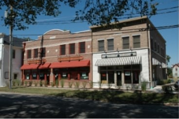


Property Detail
40W484 Rte 64
08-23-202-003
KANE
Commercialnec
Illinois
B and X Area of moderate flood hazard, usually the area between the limits of the 100-year and 500-year floods.
3
2024
0.36 AC
2024
Western East/West Corr
852404
Chicago
9,600 SF
Chicago-Naperville-Elgin, IL-IN
NEARBY LISTINGS FOR SALE OR LEASE
-
-
View all Wasco listings for sale on LoopNet.com
DEMOGRAPHICS near 40W484 Rte 64
1 mile
3 mile
5 mile
2025 Total Population
2,459
15,121
62,675
2030 Population
2,411
14,844
62,822
Pop Growth 2025-2030
(1.95%)
(1.83%)
+ 0.23%
Average Age
41
42
41
2025 Total Households
772
4,963
21,992
HH Growth 2025-2030
(2.07%)
(1.89%)
+ 0.26%
Median Household Inc
$215,588
$170,345
$138,184
Avg Household Size
3.20
3.00
2.80
2025 Avg HH Vehicles
3.00
3.00
2.00
Median Home Value
$645,178
$513,838
$468,007
Median Year Built
1994
1991
1994
Nearby Places
Map Layers
Map Styles
 Street
 Aerial
Layers
 Traffic
 Biking
Places
Listings with unknown addresses are not visible on the map
- Restaurants
- Banks
- Shops
- Fitness
- Groceries
PUBLIC TRANSPORTATION
COMMUTER RAIL
La Fox Station (Union Pacific West Line - Northeast Illinois Regional Commuter Railroad (Metra))
Drive
Walk
Distance
La Fox Station (Union Pacific West Line - Northeast Illinois Regional Commuter Railroad (Metra))
11 min
5.0 mi
Geneva Station (Union Pacific West Line - Northeast Illinois Regional Commuter Railroad (Metra))
Drive
Walk
Distance
Geneva Station (Union Pacific West Line - Northeast Illinois Regional Commuter Railroad (Metra))
13 min
7.1 mi
AIRPORT
Chicago O'Hare International
Drive
Walk
Distance
Chicago O'Hare International
70 min
32.2 mi
Chicago Midway International
Drive
Walk
Distance
Chicago Midway International
76 min
42.0 mi
Nearby Properties
Address
Land Use
TOTAL SIZE
Lot Size
Zoning
Address
Land Use
TOTAL SIZE
Lot Size
Zoning
Address
Land Use
TOTAL SIZE
Lot Size
Zoning
7,632 SF
94.93 AC
Address
Land Use
TOTAL SIZE
Lot Size
Zoning
25,984 SF
2.43 AC
Address
Land Use
TOTAL SIZE
Lot Size
Zoning
8,575 SF
3.42 AC
Address
Land Use
TOTAL SIZE
Lot Size
Zoning
24,000 SF
1.87 AC
Address
Land Use
TOTAL SIZE
Lot Size
Zoning
14,411 SF
1.91 AC
Address
Land Use
TOTAL SIZE
Lot Size
Zoning
Address
Land Use
TOTAL SIZE
Lot Size
Zoning
61.01 AC
Address
Land Use
TOTAL SIZE
Lot Size
Zoning
11,480 SF
Address
Land Use
TOTAL SIZE
Lot Size
Zoning
11,572 SF
1.33 AC
Address
Land Use
TOTAL SIZE
Lot Size
Zoning
11,000 SF
0.34 AC
Address
Land Use
TOTAL SIZE
Lot Size
Zoning
24,000 SF
5 AC
Address
Land Use
TOTAL SIZE
Lot Size
Zoning
2,400 SF
0.82 AC
Address
Land Use
TOTAL SIZE
Lot Size
Zoning
6,000 SF
2.01 AC
Address
Land Use
TOTAL SIZE
Lot Size
Zoning
5,000 SF
0.29 AC
Address
Land Use
TOTAL SIZE
Lot Size
Zoning
4,124 SF
21.28 AC
Address
Land Use
TOTAL SIZE
Lot Size
Zoning
4,394 SF
1.25 AC
Address
Land Use
TOTAL SIZE
Lot Size
Zoning
5,800 SF
1.14 AC
Address
Land Use
TOTAL SIZE
Lot Size
Zoning
3,281 SF
4.02 AC
Address
Land Use
TOTAL SIZE
Lot Size
Zoning
6,558 SF
1.02 AC
Address
Land Use
TOTAL SIZE
Lot Size
Zoning
4,092 SF
1.33 AC
Address
Land Use
TOTAL SIZE
Lot Size
Zoning
7,408 SF
Address
Land Use
TOTAL SIZE
Lot Size
Zoning
0.48 AC
Address
Land Use
TOTAL SIZE
Lot Size
Zoning
4,128 SF
4.67 AC
Address
Land Use
TOTAL SIZE
Lot Size
Zoning
12,292 SF
0.74 AC
Address
Land Use
TOTAL SIZE
Lot Size
Zoning
3,598 SF
7 AC
Address
Land Use
TOTAL SIZE
Lot Size
Zoning
30.93 AC
Address
Land Use
TOTAL SIZE
Lot Size
Zoning
6,095 SF
0.44 AC
Address
Land Use
TOTAL SIZE
Lot Size
Zoning
4,387 SF
1.70 AC
The World's #1 Commercial Real Estate Marketplace
Connect with us
© 2026 CoStar Group
The information above has been obtained from sources believed reliable. While we do not doubt its accuracy we have not verified it and make no guarantee, warranty or representation about it. It is your responsibility to independently confirm its accuracy and completeness. Any projections, opinions, assumptions, or estimates used are for example only and do not represent the current or future performance of the property. The value of this transaction to you depends on tax and other factors which should be evaluated by your tax, financial, and legal advisors. You and your advisors should conduct a careful, independent investigation of the property to determine to your satisfaction the suitability of the property for your needs.