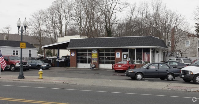
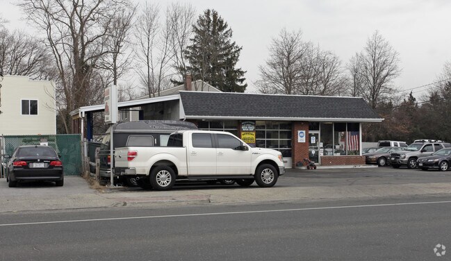
Property Record
41 E Main St, East Islip, NY 11730

Property Detail
41 E Main St
Nassau County-Suffolk County, NY
X2224709Y185447 N060N00000000
0500-372-00-02-00-045-000
Suffolk
Autorepair
New York
BUS1
200
B and X Area of moderate flood hazard, usually the area between the limits of the 100-year and 500-year floods.
0.28 AC
0
Southwestern Suffolk
2025
Long Island (New York)
147505
NEARBY LISTINGS FOR SALE OR LEASE
DEMOGRAPHICS near 41 E Main St
1 mile
3 mile
5 mile
2025 Total Population
12,948
63,228
174,994
2030 Population
12,879
62,429
171,719
Pop Growth 2025-2030
(0.53%)
(1.26%)
(1.87%)
Average Age
42
41
40
2025 Total Households
4,466
21,066
52,605
HH Growth 2025-2030
(0.83%)
(1.23%)
(1.75%)
Median Household Inc
$145,080
$125,988
$118,516
Avg Household Size
2.80
2.90
3.10
2025 Avg HH Vehicles
2.00
2.00
2.00
Median Home Value
$680,352
$598,343
$520,395
Median Year Built
1958
1965
1965
Nearby Places
Map Layers
Map Styles
 Street
 Aerial
Layers
 Traffic
 Biking
Places
Listings with unknown addresses are not visible on the map
- Restaurants
- Banks
- Shops
- Fitness
- Groceries
PUBLIC TRANSPORTATION
COMMUTER RAIL
Great River Station (Montauk Branch - Long Island Rail Road)
Drive
Walk
Distance
Great River Station (Montauk Branch - Long Island Rail Road)
3 min
1.5 mi
Islip Station (Montauk Branch - Long Island Rail Road)
Drive
Walk
Distance
Islip Station (Montauk Branch - Long Island Rail Road)
3 min
1.5 mi
AIRPORT
Long Island MacArthur
Drive
Walk
Distance
Long Island MacArthur
16 min
9.0 mi
John F Kennedy International
Drive
Walk
Distance
John F Kennedy International
50 min
36.6 mi
Nearby Properties
Address
Land Use
TOTAL SIZE
Lot Size
Zoning
Address
Land Use
TOTAL SIZE
Lot Size
Zoning
1,941.51 AC
AAA
Address
Land Use
TOTAL SIZE
Lot Size
Zoning
2,057.30 AC
AAA
Address
Land Use
TOTAL SIZE
Lot Size
Zoning
18.89 AC
Address
Land Use
TOTAL SIZE
Lot Size
Zoning
57.30 AC
IND1
Address
Land Use
TOTAL SIZE
Lot Size
Zoning
334.30 AC
AAA
Address
Land Use
TOTAL SIZE
Lot Size
Zoning
17.70 AC
A
Address
Land Use
TOTAL SIZE
Lot Size
Zoning
38.74 AC
Address
Land Use
TOTAL SIZE
Lot Size
Zoning
465.70 AC
AAA
Address
Land Use
TOTAL SIZE
Lot Size
Zoning
33.30 AC
A
Address
Land Use
TOTAL SIZE
Lot Size
Zoning
216.20 AC
AAA
Address
Land Use
TOTAL SIZE
Lot Size
Zoning
339.70 AC
AAA
Address
Land Use
TOTAL SIZE
Lot Size
Zoning
41 AC
PDDGROI
Address
Land Use
TOTAL SIZE
Lot Size
Zoning
15.46 AC
PDDEC
Address
Land Use
TOTAL SIZE
Lot Size
Zoning
17.51 AC
Address
Land Use
TOTAL SIZE
Lot Size
Zoning
15.60 AC
BUS3
Address
Land Use
TOTAL SIZE
Lot Size
Zoning
19.86 AC
C
Address
Land Use
TOTAL SIZE
Lot Size
Zoning
10.90 AC
B
Address
Land Use
TOTAL SIZE
Lot Size
Zoning
Address
Land Use
TOTAL SIZE
Lot Size
Zoning
19.04 AC
BUS1
Address
Land Use
TOTAL SIZE
Lot Size
Zoning
66 AC
AAA
Address
Land Use
TOTAL SIZE
Lot Size
Zoning
11.05 AC
PDDOFF
Address
Land Use
TOTAL SIZE
Lot Size
Zoning
16 AC
PDDRI
Address
Land Use
TOTAL SIZE
Lot Size
Zoning
46.60 AC
A
Address
Land Use
TOTAL SIZE
Lot Size
Zoning
7.70 AC
A
Address
Land Use
TOTAL SIZE
Lot Size
Zoning
20 AC
PDDRI
Address
Land Use
TOTAL SIZE
Lot Size
Zoning
9.68 AC
PDDSC
Address
Land Use
TOTAL SIZE
Lot Size
Zoning
9.79 AC
PDDRS
Address
Land Use
TOTAL SIZE
Lot Size
Zoning
14.73 AC
A
Address
Land Use
TOTAL SIZE
Lot Size
Zoning
45.47 AC
PDDEC
Address
Land Use
TOTAL SIZE
Lot Size
Zoning
The World's #1 Commercial Real Estate Marketplace
Connect with us
© 2026 CoStar Group
The information above has been obtained from sources believed reliable. While we do not doubt its accuracy we have not verified it and make no guarantee, warranty or representation about it. It is your responsibility to independently confirm its accuracy and completeness. Any projections, opinions, assumptions, or estimates used are for example only and do not represent the current or future performance of the property. The value of this transaction to you depends on tax and other factors which should be evaluated by your tax, financial, and legal advisors. You and your advisors should conduct a careful, independent investigation of the property to determine to your satisfaction the suitability of the property for your needs.