Property Record
41 Falls Rd, Shelburne, VT 05482
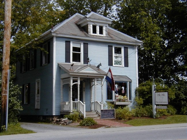

Property Detail
41 Falls Rd
Burlington-South Burlington, VT
.29A; COMM
(183) 002-0041
CHITTENDEN
Commercialnec
Vermont
B and X Area of moderate flood hazard, usually the area between the limits of the 100-year and 500-year floods.
0.29 AC
0
Vermont North Area
2025
Other Market Areas
003401
NEARBY LISTINGS FOR SALE OR LEASE
-
-
View all Shelburne listings for sale on LoopNet.com
DEMOGRAPHICS near 41 Falls Rd
1 mile
3 mile
5 mile
2025 Total Population
2,369
8,191
21,437
2030 Population
2,398
8,347
21,871
Pop Growth 2025-2030
+ 1.22%
+ 1.90%
+ 2.02%
Average Age
46
46
43
2025 Total Households
1,010
3,383
8,705
HH Growth 2025-2030
+ 1.39%
+ 2.04%
+ 2.18%
Median Household Inc
$123,508
$131,579
$136,283
Avg Household Size
2.30
2.40
2.30
2025 Avg HH Vehicles
2.00
2.00
2.00
Median Home Value
$590,000
$606,601
$599,834
Median Year Built
1985
1984
1986
Nearby Places
Map Layers
Map Styles
 Street
 Aerial
Layers
 Traffic
 Biking
Places
Listings with unknown addresses are not visible on the map
- Restaurants
- Banks
- Shops
- Fitness
- Groceries
PUBLIC TRANSPORTATION
COMMUTER RAIL
Burlington (Ethan Allen Express - Amtrak)
Drive
Walk
Distance
Burlington (Ethan Allen Express - Amtrak)
17 min
7.6 mi
AIRPORT
Patrick Leahy Burlington International
Drive
Walk
Distance
Patrick Leahy Burlington International
26 min
11.7 mi
Plattsburgh International
Drive
Walk
Distance
Plattsburgh International
79 min
41.1 mi
Freight Ports
Montreal
Drive
Walk
Distance
Montreal
137 min
104.4 mi
Nearby Properties
Address
Land Use
TOTAL SIZE
Lot Size
Zoning
Address
Land Use
TOTAL SIZE
Lot Size
Zoning
136.41 AC
Address
Land Use
TOTAL SIZE
Lot Size
Zoning
Address
Land Use
TOTAL SIZE
Lot Size
Zoning
1,339.01 AC
Address
Land Use
TOTAL SIZE
Lot Size
Zoning
1,024.39 AC
Address
Land Use
TOTAL SIZE
Lot Size
Zoning
Address
Land Use
TOTAL SIZE
Lot Size
Zoning
137.42 AC
Address
Land Use
TOTAL SIZE
Lot Size
Zoning
2.68 AC
Address
Land Use
TOTAL SIZE
Lot Size
Zoning
6.27 AC
Address
Land Use
TOTAL SIZE
Lot Size
Zoning
27.37 AC
Address
Land Use
TOTAL SIZE
Lot Size
Zoning
14.62 AC
Address
Land Use
TOTAL SIZE
Lot Size
Zoning
4.20 AC
Address
Land Use
TOTAL SIZE
Lot Size
Zoning
41.34 AC
Address
Land Use
TOTAL SIZE
Lot Size
Zoning
19.07 AC
Address
Land Use
TOTAL SIZE
Lot Size
Zoning
Address
Land Use
TOTAL SIZE
Lot Size
Zoning
10.09 AC
Address
Land Use
TOTAL SIZE
Lot Size
Zoning
Address
Land Use
TOTAL SIZE
Lot Size
Zoning
Address
Land Use
TOTAL SIZE
Lot Size
Zoning
26.13 AC
Address
Land Use
TOTAL SIZE
Lot Size
Zoning
113.38 AC
Address
Land Use
TOTAL SIZE
Lot Size
Zoning
134.70 AC
Address
Land Use
TOTAL SIZE
Lot Size
Zoning
11.04 AC
Address
Land Use
TOTAL SIZE
Lot Size
Zoning
50.88 AC
Address
Land Use
TOTAL SIZE
Lot Size
Zoning
1.59 AC
Address
Land Use
TOTAL SIZE
Lot Size
Zoning
1.77 AC
Address
Land Use
TOTAL SIZE
Lot Size
Zoning
1.98 AC
Address
Land Use
TOTAL SIZE
Lot Size
Zoning
583.23 AC
Address
Land Use
TOTAL SIZE
Lot Size
Zoning
3.02 AC
Address
Land Use
TOTAL SIZE
Lot Size
Zoning
Address
Land Use
TOTAL SIZE
Lot Size
Zoning
Address
Land Use
TOTAL SIZE
Lot Size
Zoning
The World's #1 Commercial Real Estate Marketplace
Connect with us
© 2026 CoStar Group
The information above has been obtained from sources believed reliable. While we do not doubt its accuracy we have not verified it and make no guarantee, warranty or representation about it. It is your responsibility to independently confirm its accuracy and completeness. Any projections, opinions, assumptions, or estimates used are for example only and do not represent the current or future performance of the property. The value of this transaction to you depends on tax and other factors which should be evaluated by your tax, financial, and legal advisors. You and your advisors should conduct a careful, independent investigation of the property to determine to your satisfaction the suitability of the property for your needs.