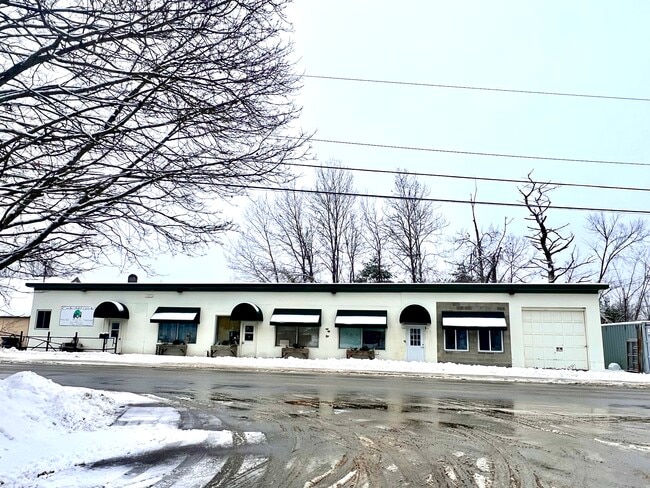
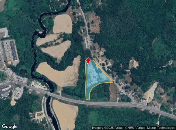
Property Record
41 Goboro Rd, Epsom, NH 03234
Current Lease Availabilities
NEARBY LISTINGS FOR SALE OR LEASE
-
-
View all Epsom listings for lease on LoopNet.com
Property Detail
41 Goboro Rd
EPSO-000005U-000000-000065
Merrimack
Commercialnec
New Hampshire
AE
65
33013C0576E
3.50 AC
2024
Concord/New Hampshire North Area
2024
Other Market Areas
034000
Concord, NH
DEMOGRAPHICS near 41 Goboro Rd
1 mile
3 mile
5 mile
2024 Total Population
1,089
4,386
9,957
2029 Population
1,139
4,612
10,496
Pop Growth 2024-2029
+ 4.59%
+ 5.15%
+ 5.41%
Average Age
43
44
44
2024 Total Households
408
1,698
3,865
HH Growth 2024-2029
+ 4.66%
+ 5.06%
+ 5.30%
Median Household Inc
$104,794
$103,113
$101,881
Avg Household Size
2.60
2.50
2.50
2024 Avg HH Vehicles
2.00
2.00
2.00
Median Home Value
$298,251
$295,976
$308,213
Median Year Built
1982
1986
1984
Nearby Places
Map Layers
Map Styles
 Street
 Aerial
Transit
 Traffic
 Biking
Places
Listings with unknown addresses are not visible on the map
- Restaurants
- Banks
- Shops
- Fitness
- Groceries
PUBLIC TRANSPORTATION
AIRPORT
Manchester Boston Regional
Drive
Walk
Distance
Manchester Boston Regional
50 min
28.0 mi
Portsmouth International at Pease
Drive
Walk
Distance
Portsmouth International at Pease
55 min
33.1 mi
Nearby Properties
Address
Land Use
TOTAL SIZE
Lot Size
Zoning
Address
Land Use
TOTAL SIZE
Lot Size
Zoning
44,963 SF
16.29 AC
COMM V
Address
Land Use
TOTAL SIZE
Lot Size
Zoning
21 AC
RES/CO
Address
Land Use
TOTAL SIZE
Lot Size
Zoning
11.40 AC
RES/CO
Address
Land Use
TOTAL SIZE
Lot Size
Zoning
2,415 SF
53 AC
RES/LT
Address
Land Use
TOTAL SIZE
Lot Size
Zoning
34,478 SF
55.60 AC
RA
Address
Land Use
TOTAL SIZE
Lot Size
Zoning
15.03 AC
RES/LT
Address
Land Use
TOTAL SIZE
Lot Size
Zoning
21,411 SF
4.26 AC
RES/CO
Address
Land Use
TOTAL SIZE
Lot Size
Zoning
28.02 AC
RES/AG
Address
Land Use
TOTAL SIZE
Lot Size
Zoning
16,246 SF
3.35 AC
COMM/I
Address
Land Use
TOTAL SIZE
Lot Size
Zoning
30,540 SF
11.94 AC
RES/CO
Address
Land Use
TOTAL SIZE
Lot Size
Zoning
17,783 SF
11.10 AC
COMM/I
Address
Land Use
TOTAL SIZE
Lot Size
Zoning
24.13 AC
RES/LT
Address
Land Use
TOTAL SIZE
Lot Size
Zoning
7,638 SF
12.80 AC
RA
Address
Land Use
TOTAL SIZE
Lot Size
Zoning
3,596 SF
2.04 AC
COMM V
Address
Land Use
TOTAL SIZE
Lot Size
Zoning
43.30 AC
RA
Address
Land Use
TOTAL SIZE
Lot Size
Zoning
30,221 SF
4.55 AC
RES/CO
Address
Land Use
TOTAL SIZE
Lot Size
Zoning
16,306 SF
28.99 AC
COMM/I
Address
Land Use
TOTAL SIZE
Lot Size
Zoning
4,212 SF
1.54 AC
COMM V
Address
Land Use
TOTAL SIZE
Lot Size
Zoning
23.91 AC
RES/AG
Address
Land Use
TOTAL SIZE
Lot Size
Zoning
2.72 AC
RES/CO
Address
Land Use
TOTAL SIZE
Lot Size
Zoning
6.57 AC
RES/CO
Address
Land Use
TOTAL SIZE
Lot Size
Zoning
4.16 AC
RES/LT
Address
Land Use
TOTAL SIZE
Lot Size
Zoning
5.01 AC
RES/CO
Address
Land Use
TOTAL SIZE
Lot Size
Zoning
2,679 SF
70 AC
COMM/I
Address
Land Use
TOTAL SIZE
Lot Size
Zoning
5,751 SF
2.94 AC
RES/CO
Address
Land Use
TOTAL SIZE
Lot Size
Zoning
9,344 SF
6.07 AC
COMM/I
Address
Land Use
TOTAL SIZE
Lot Size
Zoning
15,257 SF
3.51 AC
RES/CO
Address
Land Use
TOTAL SIZE
Lot Size
Zoning
8,175 SF
5.20 AC
COMM/I
Address
Land Use
TOTAL SIZE
Lot Size
Zoning
6.87 AC
RES/LT
Address
Land Use
TOTAL SIZE
Lot Size
Zoning
5.30 AC
RES/LT
The World's #1 Commercial Real Estate Marketplace
Connect with us
© 2026 CoStar Group
The information above has been obtained from sources believed reliable. While we do not doubt its accuracy we have not verified it and make no guarantee, warranty or representation about it. It is your responsibility to independently confirm its accuracy and completeness. Any projections, opinions, assumptions, or estimates used are for example only and do not represent the current or future performance of the property. The value of this transaction to you depends on tax and other factors which should be evaluated by your tax, financial, and legal advisors. You and your advisors should conduct a careful, independent investigation of the property to determine to your satisfaction the suitability of the property for your needs.