Property Record
41 Hay Rd, Perry, GA 31069
Save to a Folder
{{folder.Name}}
{{folder.ListingIds.length}} Properties
{{folder.ListingIds.length}} Property
Create a New Folder
Property Detail
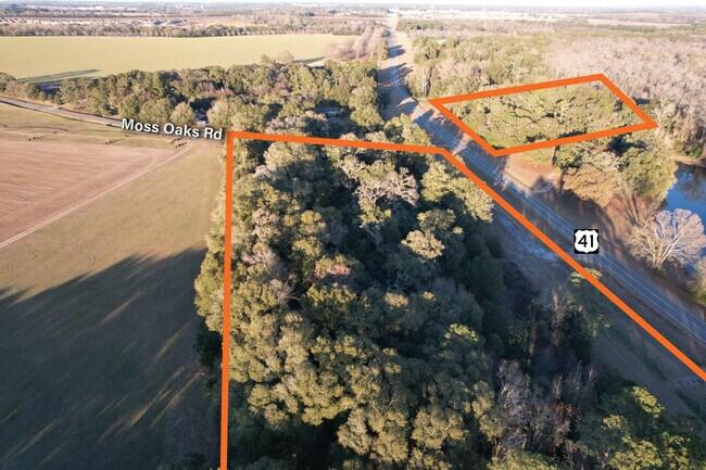
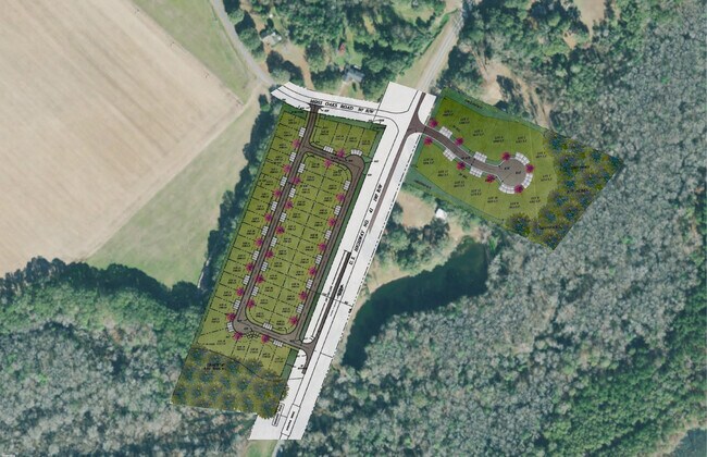
41 Hay Rd
0P0340045000
TRACT B 0.55 ACRE LL 80 14TH LD
Motel
HOUSTON
PUD
Georgia
B and X Area of moderate flood hazard, usually the area between the limits of the 100-year and 500-year floods.
2.36 AC
2025
Perry/Warner Robins
2025
Other Market Areas
021206
Warner Robins, GA
2,213 SF
NEARBY LISTINGS FOR SALE OR LEASE
DEMOGRAPHICS near 41 Hay Rd
1 mile
3 mile
5 mile
2025 Total Population
698
3,552
14,575
2030 Population
764
3,834
15,540
Pop Growth 2025-2030
+ 9.46%
+ 7.94%
+ 6.62%
Average Age
42
42
41
2025 Total Households
293
1,388
5,760
HH Growth 2025-2030
+ 9.56%
+ 8.21%
+ 6.79%
Median Household Inc
$71,874
$59,999
$68,224
Avg Household Size
2.40
2.50
2.40
2025 Avg HH Vehicles
2.00
2.00
2.00
Median Home Value
$233,333
$215,818
$212,523
Median Year Built
1993
1987
1988
Nearby Places
Map Layers
Map Styles
 Street
 Aerial
Layers
 Traffic
 Biking
Places
Listings with unknown addresses are not visible on the map
- Restaurants
- Banks
- Shops
- Fitness
- Groceries
SALE & LEASE HISTORY
LISTING DATE
SALE/LEASE

Jan 04, 2023
For Sale
Nearby Properties
Address
Land Use
TOTAL SIZE
Lot Size
Zoning
Address
Land Use
TOTAL SIZE
Lot Size
Zoning
68,186 SF
559.30 AC
GU
Address
Land Use
TOTAL SIZE
Lot Size
Zoning
525,957 SF
32.75 AC
M2
Address
Land Use
TOTAL SIZE
Lot Size
Zoning
65,040 SF
35.91 AC
M2
Address
Land Use
TOTAL SIZE
Lot Size
Zoning
19,125 SF
27.94 AC
R1
Address
Land Use
TOTAL SIZE
Lot Size
Zoning
44,292 SF
9.70 AC
FBR
Address
Land Use
TOTAL SIZE
Lot Size
Zoning
255.39 AC
GU/M1
Address
Land Use
TOTAL SIZE
Lot Size
Zoning
1,023 SF
463.22 AC
RAG
Address
Land Use
TOTAL SIZE
Lot Size
Zoning
134,145 SF
3.08 AC
M2
Address
Land Use
TOTAL SIZE
Lot Size
Zoning
134,145 SF
3.08 AC
M2
Address
Land Use
TOTAL SIZE
Lot Size
Zoning
4,704 SF
107.57 AC
C1 R3 R1
Address
Land Use
TOTAL SIZE
Lot Size
Zoning
57,534 SF
2.50 AC
IMU
Address
Land Use
TOTAL SIZE
Lot Size
Zoning
64,000 SF
35.91 AC
M2
Address
Land Use
TOTAL SIZE
Lot Size
Zoning
14,232 SF
16.53 AC
M2
Address
Land Use
TOTAL SIZE
Lot Size
Zoning
38,469 SF
1.80 AC
IMU
Address
Land Use
TOTAL SIZE
Lot Size
Zoning
85,624 SF
10.52 AC
M1
Address
Land Use
TOTAL SIZE
Lot Size
Zoning
26,657 SF
1.65 AC
C2
Address
Land Use
TOTAL SIZE
Lot Size
Zoning
7,575 SF
4.52 AC
C2
Address
Land Use
TOTAL SIZE
Lot Size
Zoning
359.62 AC
RAG
Address
Land Use
TOTAL SIZE
Lot Size
Zoning
9,152 SF
2.76 AC
MUC
Address
Land Use
TOTAL SIZE
Lot Size
Zoning
9,964 SF
2.95 AC
IMU
Address
Land Use
TOTAL SIZE
Lot Size
Zoning
68.46 AC
R3
Address
Land Use
TOTAL SIZE
Lot Size
Zoning
8,100 SF
4.19 AC
IMU
Address
Land Use
TOTAL SIZE
Lot Size
Zoning
461.02 AC
RAG
Address
Land Use
TOTAL SIZE
Lot Size
Zoning
13,920 SF
2.54 AC
IMU
Address
Land Use
TOTAL SIZE
Lot Size
Zoning
12,048 SF
2.88 AC
C2
Address
Land Use
TOTAL SIZE
Lot Size
Zoning
25,178 SF
4.65 AC
C2
Address
Land Use
TOTAL SIZE
Lot Size
Zoning
689.95 AC
RAG
Address
Land Use
TOTAL SIZE
Lot Size
Zoning
345.51 AC
RAG
Address
Land Use
TOTAL SIZE
Lot Size
Zoning
4,350 SF
0.88 AC
MUC
Address
Land Use
TOTAL SIZE
Lot Size
Zoning
645.75 AC
RAG
The World's #1 Commercial Real Estate Marketplace
Connect with us
© 2026 CoStar Group
The information above has been obtained from sources believed reliable. While we do not doubt its accuracy we have not verified it and make no guarantee, warranty or representation about it. It is your responsibility to independently confirm its accuracy and completeness. Any projections, opinions, assumptions, or estimates used are for example only and do not represent the current or future performance of the property. The value of this transaction to you depends on tax and other factors which should be evaluated by your tax, financial, and legal advisors. You and your advisors should conduct a careful, independent investigation of the property to determine to your satisfaction the suitability of the property for your needs.