Property Record
41 Highway, Apollo Beach, FL 33572
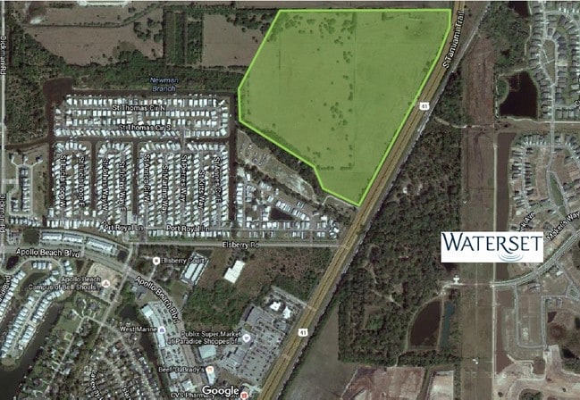
Property Detail
41 Highway
Tampa-St. Petersburg-Clearwater, FL
RUSKIN TOMATO FARMS E 360.27 FT OF TRACT 15 AND LOT 16 LYING W OF SR NO 45
U-22-31-19-1SF-000000-01100.0
HILLSBOROUGH
Residentialacreage
Florida
ASC-1
16
AE The base floodplain where base flood elevations are provided. AE Zones are now used on new format FIRMs instead of A1-A30 Zones.
15.14 AC
2024
Southeast Hillsborough
2025
Tampa/St Petersburg
014106
NEARBY LISTINGS FOR SALE OR LEASE
DEMOGRAPHICS near 41 Highway
1 mile
3 mile
5 mile
2025 Total Population
5,219
41,081
128,749
2030 Population
5,823
45,554
141,040
Pop Growth 2025-2030
+ 11.57%
+ 10.89%
+ 9.55%
Average Age
43
41
41
2025 Total Households
2,093
15,371
46,001
HH Growth 2025-2030
+ 11.56%
+ 10.94%
+ 9.75%
Median Household Inc
$117,245
$107,624
$95,796
Avg Household Size
2.50
2.70
2.70
2025 Avg HH Vehicles
2.00
2.00
2.00
Median Home Value
$496,337
$472,910
$394,489
Median Year Built
2009
2010
2009
Nearby Places
Map Layers
Map Styles
 Street
 Aerial
Transit
 Traffic
 Biking
Places
Listings with unknown addresses are not visible on the map
- Restaurants
- Banks
- Shops
- Fitness
- Groceries
PUBLIC TRANSPORTATION
AIRPORT
Tampa International
Drive
Walk
Distance
Tampa International
40 min
25.2 mi
Sarasota/Bradenton International
Drive
Walk
Distance
Sarasota/Bradenton International
51 min
32.8 mi
St Pete-Clearwater International
Drive
Walk
Distance
St Pete-Clearwater International
57 min
34.4 mi
Freight Ports
Port of Tampa Bay
Drive
Walk
Distance
Port of Tampa Bay
24 min
14.5 mi
SALE & LEASE HISTORY
LISTING DATE
SALE/LEASE

Sep 24, 2016
For Sale
Nearby Properties
Address
Land Use
TOTAL SIZE
Lot Size
Zoning
Address
Land Use
TOTAL SIZE
Lot Size
Zoning
688,390 SF
68.52 AC
PD
Address
Land Use
TOTAL SIZE
Lot Size
Zoning
503,703 SF
21 AC
PD
Address
Land Use
TOTAL SIZE
Lot Size
Zoning
369,777 SF
21.49 AC
PD
Address
Land Use
TOTAL SIZE
Lot Size
Zoning
493,204 SF
65.35 AC
M
Address
Land Use
TOTAL SIZE
Lot Size
Zoning
593,167 SF
416.07 AC
M
Address
Land Use
TOTAL SIZE
Lot Size
Zoning
334,871 SF
15 AC
PD
Address
Land Use
TOTAL SIZE
Lot Size
Zoning
251,817 SF
13.82 AC
PD
Address
Land Use
TOTAL SIZE
Lot Size
Zoning
154,232 SF
17.40 AC
PD
Address
Land Use
TOTAL SIZE
Lot Size
Zoning
347,147 SF
258.94 AC
PD
Address
Land Use
TOTAL SIZE
Lot Size
Zoning
425,231 SF
23.78 AC
M
Address
Land Use
TOTAL SIZE
Lot Size
Zoning
101,768 SF
17.95 AC
PD
Address
Land Use
TOTAL SIZE
Lot Size
Zoning
146,440 SF
18.56 AC
PD
Address
Land Use
TOTAL SIZE
Lot Size
Zoning
48,968 SF
10 AC
PD
Address
Land Use
TOTAL SIZE
Lot Size
Zoning
441,257 SF
107.09 AC
AR
Address
Land Use
TOTAL SIZE
Lot Size
Zoning
520,366 SF
122.24 AC
PD
Address
Land Use
TOTAL SIZE
Lot Size
Zoning
178,496 SF
17.63 AC
PD
Address
Land Use
TOTAL SIZE
Lot Size
Zoning
138,397 SF
36.94 AC
PD
Address
Land Use
TOTAL SIZE
Lot Size
Zoning
64,512 SF
22.32 AC
PD
Address
Land Use
TOTAL SIZE
Lot Size
Zoning
157,883 SF
18.57 AC
PD
Address
Land Use
TOTAL SIZE
Lot Size
Zoning
191,459 SF
13.60 AC
M
Address
Land Use
TOTAL SIZE
Lot Size
Zoning
137,570 SF
12.42 AC
M
Address
Land Use
TOTAL SIZE
Lot Size
Zoning
108,036 SF
11.70 AC
PD
Address
Land Use
TOTAL SIZE
Lot Size
Zoning
93,256 SF
14.82 AC
PD
Address
Land Use
TOTAL SIZE
Lot Size
Zoning
94,955 SF
13.55 AC
PD
Address
Land Use
TOTAL SIZE
Lot Size
Zoning
88,445 SF
14.41 AC
PD
Address
Land Use
TOTAL SIZE
Lot Size
Zoning
60,119 SF
8.31 AC
PD
Address
Land Use
TOTAL SIZE
Lot Size
Zoning
230,880 SF
25.13 AC
AI
Address
Land Use
TOTAL SIZE
Lot Size
Zoning
81,193 SF
11.41 AC
PD
Address
Land Use
TOTAL SIZE
Lot Size
Zoning
57,821 SF
47.69 AC
AR
Address
Land Use
TOTAL SIZE
Lot Size
Zoning
110,148 SF
23.04 AC
M
The World's #1 Commercial Real Estate Marketplace
Connect with us
© 2026 CoStar Group
The information above has been obtained from sources believed reliable. While we do not doubt its accuracy we have not verified it and make no guarantee, warranty or representation about it. It is your responsibility to independently confirm its accuracy and completeness. Any projections, opinions, assumptions, or estimates used are for example only and do not represent the current or future performance of the property. The value of this transaction to you depends on tax and other factors which should be evaluated by your tax, financial, and legal advisors. You and your advisors should conduct a careful, independent investigation of the property to determine to your satisfaction the suitability of the property for your needs.