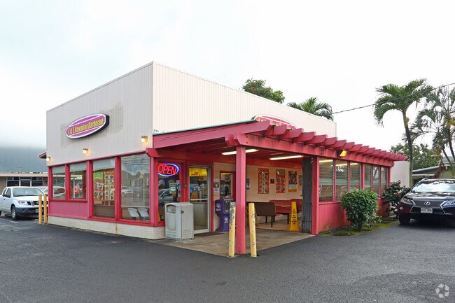
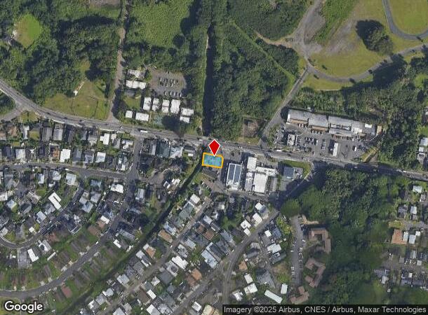
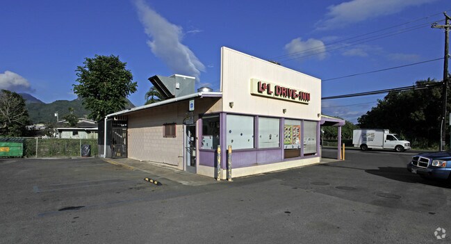
Property Record
41 Kalanianaole Hwy, Waimanalo, HI 96795
NEARBY LISTINGS FOR SALE OR LEASE
Property Detail
41 Kalanianaole Hwy
1-4-1-022-084-0000
05
Commercialnec
Honolulu
AE
Hawaii
15003C0380H
55-a
2024
0.11 AC
2025
Windward
011300
Hawaii
850 SF
Urban Honolulu, HI
DEMOGRAPHICS near 41 Kalanianaole Hwy
1 Mile
3 Mile
5 Mile
2024 Total Population
3,619
26,008
88,559
2029 Population
3,351
24,749
85,722
Pop Growth 2024-2029
(7.41%)
(4.84%)
(3.20%)
Average Age
39
43
44
2024 Total Households
868
7,617
29,318
HH Growth 2024-2029
(8.53%)
(5.71%)
(3.92%)
Median Household Inc
$117,045
$135,476
$134,268
Avg Household Size
3.70
3.10
2.80
2024 Avg HH Vehicles
2.00
2.00
2.00
Median Home Value
$711,382
$1,017,251
$1,012,867
Median Year Built
1974
1970
1971
Nearby Places
Map Layers
Map Styles
 Street
 Aerial
- Restaurants
- Banks
- Shops
- Fitness
- Groceries
PUBLIC TRANSPORTATION
AIRPORT
Daniel K Inouye International
DRIVE
WALK
Distance
Daniel K Inouye International
35 min
18.1 mi
Freight Ports
Honolulu Harbor, Oahu
DRIVE
WALK
Distance
Honolulu Harbor, Oahu
37 min
17.3 mi
Nearby Properties
Address
Land Use
TOTAL SIZE
Lot Size
Zoning
Address
Land Use
TOTAL SIZE
Lot Size
Zoning
44,774 SF
2.74 AC
B-1
Address
Land Use
TOTAL SIZE
Lot Size
Zoning
39,898 SF
163.13 AC
P-2
Address
Land Use
TOTAL SIZE
Lot Size
Zoning
32,742 SF
2.69 AC
B-1
Address
Land Use
TOTAL SIZE
Lot Size
Zoning
21,111 SF
1.95 AC
B-1
Address
Land Use
TOTAL SIZE
Lot Size
Zoning
123,725 SF
572.87 AC
P-1
Address
Land Use
TOTAL SIZE
Lot Size
Zoning
20,297 SF
0.77 AC
B-1
Address
Land Use
TOTAL SIZE
Lot Size
Zoning
1.81 AC
R-7.5
Address
Land Use
TOTAL SIZE
Lot Size
Zoning
13,380 SF
129.86 AC
P-2
Address
Land Use
TOTAL SIZE
Lot Size
Zoning
6,217 SF
0.28 AC
R-10
Address
Land Use
TOTAL SIZE
Lot Size
Zoning
36,421 SF
1.61 AC
B-1
Address
Land Use
TOTAL SIZE
Lot Size
Zoning
4,374 SF
0.24 AC
R-10
Address
Land Use
TOTAL SIZE
Lot Size
Zoning
437 AC
AG-2
Address
Land Use
TOTAL SIZE
Lot Size
Zoning
11.25 AC
AG-1
Address
Land Use
TOTAL SIZE
Lot Size
Zoning
25.31 AC
P-2
Address
Land Use
TOTAL SIZE
Lot Size
Zoning
139.12 AC
AG-2
Address
Land Use
TOTAL SIZE
Lot Size
Zoning
2,710 SF
0.78 AC
P-1
Address
Land Use
TOTAL SIZE
Lot Size
Zoning
1,678 SF
312.95 AC
AG-2
Address
Land Use
TOTAL SIZE
Lot Size
Zoning
1,648 SF
0.62 AC
B-1
Address
Land Use
TOTAL SIZE
Lot Size
Zoning
2,771 SF
0.18 AC
R-10
Address
Land Use
TOTAL SIZE
Lot Size
Zoning
59.33 AC
AG-1
Address
Land Use
TOTAL SIZE
Lot Size
Zoning
3,882 SF
1.94 AC
P-1
Address
Land Use
TOTAL SIZE
Lot Size
Zoning
6,920 SF
1.29 AC
P-1
Address
Land Use
TOTAL SIZE
Lot Size
Zoning
64.07 AC
AG-2
Address
Land Use
TOTAL SIZE
Lot Size
Zoning
60.03 AC
AG-1
Address
Land Use
TOTAL SIZE
Lot Size
Zoning
3,176 SF
0.54 AC
R-10
Address
Land Use
TOTAL SIZE
Lot Size
Zoning
3,928 SF
0.36 AC
B-1
Address
Land Use
TOTAL SIZE
Lot Size
Zoning
4,006 SF
0.26 AC
R-10
Address
Land Use
TOTAL SIZE
Lot Size
Zoning
3,629 SF
0.76 AC
R-10
Address
Land Use
TOTAL SIZE
Lot Size
Zoning
10.89 AC
AG-2
Address
Land Use
TOTAL SIZE
Lot Size
Zoning
2,798 SF
0.96 AC
P-1
The World's #1 Commercial Real Estate Marketplace
Connect with us
© 2025 CoStar Group
The information above has been obtained from sources believed reliable. While we do not doubt its accuracy we have not verified it and make no guarantee, warranty or representation about it. It is your responsibility to independently confirm its accuracy and completeness. Any projections, opinions, assumptions, or estimates used are for example only and do not represent the current or future performance of the property. The value of this transaction to you depends on tax and other factors which should be evaluated by your tax, financial, and legal advisors. You and your advisors should conduct a careful, independent investigation of the property to determine to your satisfaction the suitability of the property for your needs.