Property Record
41 Main St, Ashburnham, MA 01430
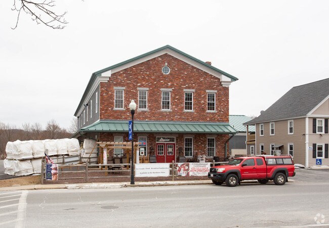

Property Detail
41 Main St
ASHB-000062-000000-000127
Worcester
Commercialofficeresidentialmixeduse
Massachusetts
B and X Area of moderate flood hazard, usually the area between the limits of the 100-year and 500-year floods.
1.11 AC
2025
Outlying Worcester
2025
Boston
700100
Worcester, MA
13,800 SF
NEARBY LISTINGS FOR SALE OR LEASE
-
-
View all Ashburnham listings for sale on LoopNet.com
DEMOGRAPHICS near 41 Main St
1 mile
3 mile
5 mile
2025 Total Population
1,677
5,485
13,290
2030 Population
1,747
5,758
13,891
Pop Growth 2025-2030
+ 4.17%
+ 4.98%
+ 4.52%
Average Age
42
42
43
2025 Total Households
578
2,020
4,818
HH Growth 2025-2030
+ 4.50%
+ 5.15%
+ 4.75%
Median Household Inc
$91,826
$109,229
$105,146
Avg Household Size
2.80
2.70
2.60
2025 Avg HH Vehicles
2.00
2.00
2.00
Median Home Value
$393,073
$420,823
$414,247
Median Year Built
1977
1985
1983
Nearby Places
Map Layers
Map Styles
 Street
 Aerial
Layers
 Traffic
 Biking
Places
Listings with unknown addresses are not visible on the map
- Restaurants
- Banks
- Shops
- Fitness
- Groceries
PUBLIC TRANSPORTATION
COMMUTER RAIL
Drive
Walk
Distance
17 min
8.1 mi
Fitchburg (Fitchburg/South Acton Line - Massachusetts Bay Transportation Authority Commuter Rail (Purple Line))
Drive
Walk
Distance
Fitchburg (Fitchburg/South Acton Line - Massachusetts Bay Transportation Authority Commuter Rail (Purple Line))
19 min
8.7 mi
AIRPORT
Worcester Regional
Drive
Walk
Distance
Worcester Regional
58 min
34.6 mi
Manchester Boston Regional
Drive
Walk
Distance
Manchester Boston Regional
77 min
41.9 mi
Freight Ports
Port of Boston
Drive
Walk
Distance
Port of Boston
92 min
58.7 mi
Nearby Properties
Address
Land Use
TOTAL SIZE
Lot Size
Zoning
Address
Land Use
TOTAL SIZE
Lot Size
Zoning
14.41 AC
Address
Land Use
TOTAL SIZE
Lot Size
Zoning
90,277 SF
23.30 AC
Address
Land Use
TOTAL SIZE
Lot Size
Zoning
164,401 SF
31 AC
Address
Land Use
TOTAL SIZE
Lot Size
Zoning
89,712 SF
55.30 AC
Address
Land Use
TOTAL SIZE
Lot Size
Zoning
Address
Land Use
TOTAL SIZE
Lot Size
Zoning
6,630 SF
3.50 AC
Address
Land Use
TOTAL SIZE
Lot Size
Zoning
9.20 AC
Address
Land Use
TOTAL SIZE
Lot Size
Zoning
7.25 AC
Address
Land Use
TOTAL SIZE
Lot Size
Zoning
24,220 SF
3.70 AC
Address
Land Use
TOTAL SIZE
Lot Size
Zoning
6,934 SF
5.01 AC
Address
Land Use
TOTAL SIZE
Lot Size
Zoning
Address
Land Use
TOTAL SIZE
Lot Size
Zoning
13,376 SF
40 AC
Address
Land Use
TOTAL SIZE
Lot Size
Zoning
0.83 AC
Address
Land Use
TOTAL SIZE
Lot Size
Zoning
5.52 AC
Address
Land Use
TOTAL SIZE
Lot Size
Zoning
41,660 SF
2.96 AC
Address
Land Use
TOTAL SIZE
Lot Size
Zoning
1.30 AC
Address
Land Use
TOTAL SIZE
Lot Size
Zoning
1,191 SF
2.90 AC
Address
Land Use
TOTAL SIZE
Lot Size
Zoning
18,702 SF
2.05 AC
Address
Land Use
TOTAL SIZE
Lot Size
Zoning
9.64 AC
Address
Land Use
TOTAL SIZE
Lot Size
Zoning
Address
Land Use
TOTAL SIZE
Lot Size
Zoning
214.51 AC
Address
Land Use
TOTAL SIZE
Lot Size
Zoning
Address
Land Use
TOTAL SIZE
Lot Size
Zoning
166.50 AC
Address
Land Use
TOTAL SIZE
Lot Size
Zoning
15,920 SF
3.27 AC
Address
Land Use
TOTAL SIZE
Lot Size
Zoning
11,434 SF
3.90 AC
Address
Land Use
TOTAL SIZE
Lot Size
Zoning
Address
Land Use
TOTAL SIZE
Lot Size
Zoning
6.41 AC
Address
Land Use
TOTAL SIZE
Lot Size
Zoning
11.01 AC
Address
Land Use
TOTAL SIZE
Lot Size
Zoning
7,622 SF
2.46 AC
The World's #1 Commercial Real Estate Marketplace
Connect with us
© 2026 CoStar Group
The information above has been obtained from sources believed reliable. While we do not doubt its accuracy we have not verified it and make no guarantee, warranty or representation about it. It is your responsibility to independently confirm its accuracy and completeness. Any projections, opinions, assumptions, or estimates used are for example only and do not represent the current or future performance of the property. The value of this transaction to you depends on tax and other factors which should be evaluated by your tax, financial, and legal advisors. You and your advisors should conduct a careful, independent investigation of the property to determine to your satisfaction the suitability of the property for your needs.