Property Record
41 Main St, Hebron, CT 06248
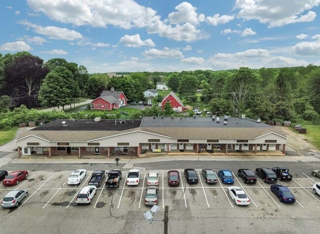

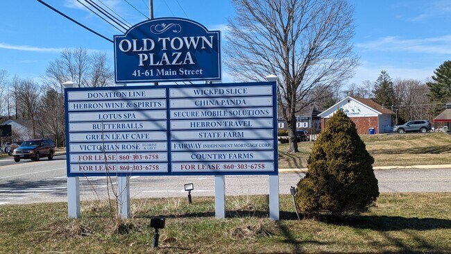
Property Detail
41 Main St
Hartford-West Hartford-East Hartford, CT
TOLLAND
HEBR-000070-000000-000015-000016-16A
Connecticut
Commercialnec
15
MS
5.07 AC
2024
Tolland County
2025
Hartford
526102
NEARBY LISTINGS FOR SALE OR LEASE
-
-
View all Hebron listings for lease on LoopNet.com
DEMOGRAPHICS near 41 Main St
1 mile
3 mile
5 mile
2025 Total Population
1,665
7,510
18,721
2030 Population
1,712
7,730
19,219
Pop Growth 2025-2030
+ 2.82%
+ 2.93%
+ 2.66%
Average Age
43
44
44
2025 Total Households
631
2,832
7,184
HH Growth 2025-2030
+ 2.85%
+ 2.90%
+ 2.63%
Median Household Inc
$138,392
$142,112
$131,468
Avg Household Size
2.60
2.60
2.60
2025 Avg HH Vehicles
2.00
2.00
2.00
Median Home Value
$381,455
$382,034
$376,729
Median Year Built
1987
1985
1982
Nearby Places
Map Layers
Map Styles
 Street
 Aerial
Transit
 Traffic
 Biking
Places
Listings with unknown addresses are not visible on the map
- Restaurants
- Banks
- Shops
- Fitness
- Groceries
PUBLIC TRANSPORTATION
AIRPORT
Bradley International
Drive
Walk
Distance
Bradley International
57 min
37.8 mi
Freight Ports
Port of New Haven
Drive
Walk
Distance
Port of New Haven
65 min
47.0 mi
SALE & LEASE HISTORY
LISTING DATE
SALE/LEASE

May 21, 2025
For Lease
Mar 21, 2024
For Sale
Jun 05, 2019
For Sale
Nearby Properties
Address
Land Use
TOTAL SIZE
Lot Size
Zoning
Address
Land Use
TOTAL SIZE
Lot Size
Zoning
51.66 AC
R-1
Address
Land Use
TOTAL SIZE
Lot Size
Zoning
111,673 SF
6.79 AC
VS
Address
Land Use
TOTAL SIZE
Lot Size
Zoning
82,384 SF
7.50 AC
R-1
Address
Land Use
TOTAL SIZE
Lot Size
Zoning
88,808 SF
25.90 AC
R-1
Address
Land Use
TOTAL SIZE
Lot Size
Zoning
13,030 SF
2.34 AC
MS
Address
Land Use
TOTAL SIZE
Lot Size
Zoning
34,102 SF
5.93 AC
MS
Address
Land Use
TOTAL SIZE
Lot Size
Zoning
15.92 AC
R-1
Address
Land Use
TOTAL SIZE
Lot Size
Zoning
11,879 SF
7.93 AC
R-1
Address
Land Use
TOTAL SIZE
Lot Size
Zoning
17.50 AC
R-1
Address
Land Use
TOTAL SIZE
Lot Size
Zoning
8,739 SF
0.70 AC
HG
Address
Land Use
TOTAL SIZE
Lot Size
Zoning
9.67 AC
R-1
Address
Land Use
TOTAL SIZE
Lot Size
Zoning
4.53 AC
R-1
Address
Land Use
TOTAL SIZE
Lot Size
Zoning
9,718 SF
4.07 AC
R-1
Address
Land Use
TOTAL SIZE
Lot Size
Zoning
12,412 SF
109.09 AC
R-1
Address
Land Use
TOTAL SIZE
Lot Size
Zoning
9,153 SF
1.44 AC
MS
Address
Land Use
TOTAL SIZE
Lot Size
Zoning
6,374 SF
12.68 AC
R-1
Address
Land Use
TOTAL SIZE
Lot Size
Zoning
6,494 SF
0.79 AC
MS
Address
Land Use
TOTAL SIZE
Lot Size
Zoning
4.03 AC
R-1
Address
Land Use
TOTAL SIZE
Lot Size
Zoning
3.50 AC
R-1
Address
Land Use
TOTAL SIZE
Lot Size
Zoning
141.86 AC
R-1
Address
Land Use
TOTAL SIZE
Lot Size
Zoning
3,224 SF
1.54 AC
MS
Address
Land Use
TOTAL SIZE
Lot Size
Zoning
945 SF
15.67 AC
R-1
Address
Land Use
TOTAL SIZE
Lot Size
Zoning
Address
Land Use
TOTAL SIZE
Lot Size
Zoning
6,192 SF
1.39 AC
MS
Address
Land Use
TOTAL SIZE
Lot Size
Zoning
6,329 SF
0.80 AC
R-1
Address
Land Use
TOTAL SIZE
Lot Size
Zoning
3.73 AC
R-1
Address
Land Use
TOTAL SIZE
Lot Size
Zoning
14,200 SF
6.54 AC
AV
Address
Land Use
TOTAL SIZE
Lot Size
Zoning
7,756 SF
1.08 AC
MS
Address
Land Use
TOTAL SIZE
Lot Size
Zoning
6,192 SF
1.50 AC
HG
The World's #1 Commercial Real Estate Marketplace
Connect with us
© 2026 CoStar Group
The information above has been obtained from sources believed reliable. While we do not doubt its accuracy we have not verified it and make no guarantee, warranty or representation about it. It is your responsibility to independently confirm its accuracy and completeness. Any projections, opinions, assumptions, or estimates used are for example only and do not represent the current or future performance of the property. The value of this transaction to you depends on tax and other factors which should be evaluated by your tax, financial, and legal advisors. You and your advisors should conduct a careful, independent investigation of the property to determine to your satisfaction the suitability of the property for your needs.