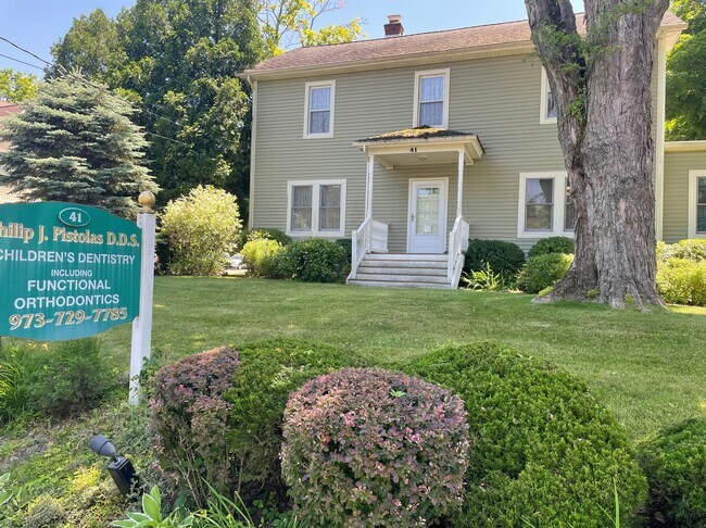
Property Record
41 Main St, Newton, NJ 07860


Property Detail
41 Main St
18-02001-0000-00044
Sussex
Medicalbuilding
New Jersey
TCMS
44
B and X Area of moderate flood hazard, usually the area between the limits of the 100-year and 500-year floods.
0.51 AC
2024
Sussex County
2025
Northern New Jersey
373300
Newark, NJ
2,672 SF
NEARBY LISTINGS FOR SALE OR LEASE
DEMOGRAPHICS near 41 Main St
1 mile
3 mile
5 mile
2025 Total Population
3,306
17,392
34,063
2030 Population
3,381
17,763
34,870
Pop Growth 2025-2030
+ 2.27%
+ 2.13%
+ 2.37%
Average Age
44
42
42
2025 Total Households
1,360
6,356
12,514
HH Growth 2025-2030
+ 2.50%
+ 2.16%
+ 2.30%
Median Household Inc
$117,132
$153,623
$144,069
Avg Household Size
2.40
2.70
2.70
2025 Avg HH Vehicles
2.00
2.00
2.00
Median Home Value
$433,408
$481,094
$454,563
Median Year Built
1973
1973
1972
Nearby Places
Map Layers
Map Styles
 Street
 Aerial
Transit
 Traffic
 Biking
Places
Listings with unknown addresses are not visible on the map
- Restaurants
- Banks
- Shops
- Fitness
- Groceries
SALE & LEASE HISTORY
LISTING DATE
SALE/LEASE

Dec 19, 2022
For Sale
Aug 26, 2023
For Sale
Nearby Properties
Address
Land Use
TOTAL SIZE
Lot Size
Zoning
Address
Land Use
TOTAL SIZE
Lot Size
Zoning
20 AC
SD-1
Address
Land Use
TOTAL SIZE
Lot Size
Zoning
49.29 AC
SD-7
Address
Land Use
TOTAL SIZE
Lot Size
Zoning
6.10 AC
T-5+
Address
Land Use
TOTAL SIZE
Lot Size
Zoning
4.56 AC
T-4
Address
Land Use
TOTAL SIZE
Lot Size
Zoning
88.63 AC
SD-2
Address
Land Use
TOTAL SIZE
Lot Size
Zoning
20.50 AC
SD-6
Address
Land Use
TOTAL SIZE
Lot Size
Zoning
47,400 SF
71 AC
SD-4
Address
Land Use
TOTAL SIZE
Lot Size
Zoning
800 SF
13.50 AC
T-3
Address
Land Use
TOTAL SIZE
Lot Size
Zoning
11.96 AC
SD-3
Address
Land Use
TOTAL SIZE
Lot Size
Zoning
7.21 AC
T-5
Address
Land Use
TOTAL SIZE
Lot Size
Zoning
12,504 SF
3.14 AC
SD-3
Address
Land Use
TOTAL SIZE
Lot Size
Zoning
Address
Land Use
TOTAL SIZE
Lot Size
Zoning
17.79 AC
SD-3
Address
Land Use
TOTAL SIZE
Lot Size
Zoning
2.09 AC
T-5
Address
Land Use
TOTAL SIZE
Lot Size
Zoning
20.62 AC
HCMF
Address
Land Use
TOTAL SIZE
Lot Size
Zoning
52.16 AC
HCMF
Address
Land Use
TOTAL SIZE
Lot Size
Zoning
72,992 SF
4.75 AC
SD-3
Address
Land Use
TOTAL SIZE
Lot Size
Zoning
5.20 AC
T-3
Address
Land Use
TOTAL SIZE
Lot Size
Zoning
50,814 SF
8.62 AC
SD-3
Address
Land Use
TOTAL SIZE
Lot Size
Zoning
26,611 SF
1.21 AC
T-5+
Address
Land Use
TOTAL SIZE
Lot Size
Zoning
45,532 SF
10.31 AC
R1
Address
Land Use
TOTAL SIZE
Lot Size
Zoning
68,221 SF
7.89 AC
SD-1
Address
Land Use
TOTAL SIZE
Lot Size
Zoning
1,140 SF
1.45 AC
SD-6
Address
Land Use
TOTAL SIZE
Lot Size
Zoning
8.90 AC
HCMF
Address
Land Use
TOTAL SIZE
Lot Size
Zoning
11 AC
SD-6
Address
Land Use
TOTAL SIZE
Lot Size
Zoning
0.56 AC
T-5
Address
Land Use
TOTAL SIZE
Lot Size
Zoning
2,982 SF
5.41 AC
SD-3
Address
Land Use
TOTAL SIZE
Lot Size
Zoning
2.24 AC
T-5
Address
Land Use
TOTAL SIZE
Lot Size
Zoning
2.49 AC
SD-3
Address
Land Use
TOTAL SIZE
Lot Size
Zoning
14,866 SF
2.09 AC
T-5
The World's #1 Commercial Real Estate Marketplace
Connect with us
© 2026 CoStar Group
The information above has been obtained from sources believed reliable. While we do not doubt its accuracy we have not verified it and make no guarantee, warranty or representation about it. It is your responsibility to independently confirm its accuracy and completeness. Any projections, opinions, assumptions, or estimates used are for example only and do not represent the current or future performance of the property. The value of this transaction to you depends on tax and other factors which should be evaluated by your tax, financial, and legal advisors. You and your advisors should conduct a careful, independent investigation of the property to determine to your satisfaction the suitability of the property for your needs.