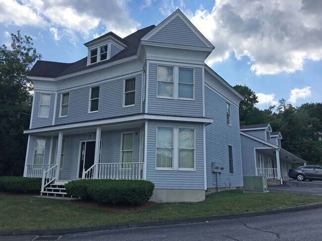
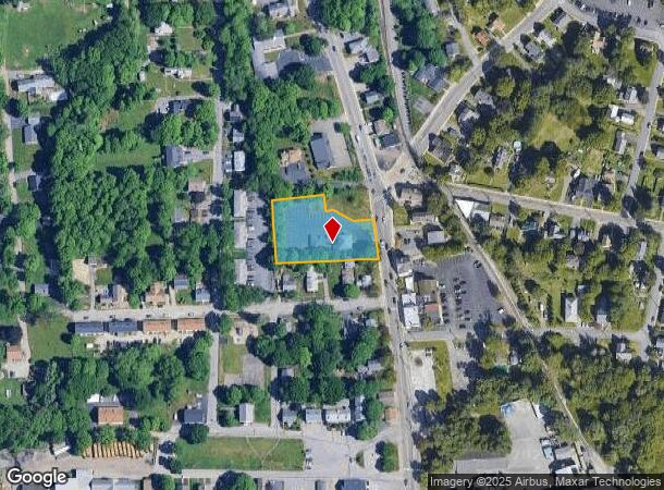
Property Record
41 N Main St, North Grafton, MA 01536


NEARBY LISTINGS FOR SALE OR LEASE
Property Detail
41 N Main St
GRAF-000027-000000-000780
Worcester
Officebuilding
Massachusetts
X
78.0
25027C0827E
0.88 AC
2025
Worcester Metro
2025
Boston
761300
Worcester, MA-CT
5,342 SF
DEMOGRAPHICS near 41 N Main St
1 Mile
3 Mile
5 Mile
2024 Total Population
3,859
33,818
143,582
2029 Population
3,876
33,977
142,907
Pop Growth 2024-2029
+ 0.44%
+ 0.47%
(0.47%)
Average Age
41
41
39
2024 Total Households
1,530
13,315
55,383
HH Growth 2024-2029
+ 0.46%
+ 0.52%
(0.45%)
Median Household Inc
$93,718
$103,340
$87,673
Avg Household Size
2.40
2.50
2.50
2024 Avg HH Vehicles
2.00
2.00
2.00
Median Home Value
$401,818
$415,717
$407,216
Median Year Built
1962
1979
1970
Nearby Places
Map Layers
Map Styles
 Street
 Aerial
- Restaurants
- Banks
- Shops
- Fitness
- Groceries
PUBLIC TRANSPORTATION
COMMUTER RAIL
Grafton (Framingham/Worcester Line - Massachusetts Bay Transportation Authority Commuter Rail (Purple Line))
DRIVE
WALK
Distance
Grafton (Framingham/Worcester Line - Massachusetts Bay Transportation Authority Commuter Rail (Purple Line))
4 min
2.0 mi
Westborough (Framingham/Worcester Line - Massachusetts Bay Transportation Authority Commuter Rail (Purple Line))
DRIVE
WALK
Distance
Westborough (Framingham/Worcester Line - Massachusetts Bay Transportation Authority Commuter Rail (Purple Line))
11 min
5.0 mi
AIRPORT
Worcester Regional
DRIVE
WALK
Distance
Worcester Regional
23 min
11.8 mi
Freight Ports
Port of Boston
DRIVE
WALK
Distance
Port of Boston
58 min
42.8 mi
SALE & LEASE HISTORY
LISTING DATE
SALE/LEASE

Jul 02, 2021
For Sale
Nearby Properties
Address
Land Use
TOTAL SIZE
Lot Size
Zoning
Address
Land Use
TOTAL SIZE
Lot Size
Zoning
46.50 AC
R4
Address
Land Use
TOTAL SIZE
Lot Size
Zoning
43.07 AC
COM BU
Address
Land Use
TOTAL SIZE
Lot Size
Zoning
375.66 AC
OLI
Address
Land Use
TOTAL SIZE
Lot Size
Zoning
210,168 SF
45.75 AC
RL-7
Address
Land Use
TOTAL SIZE
Lot Size
Zoning
412,272 SF
42.44 AC
OFF-RE
Address
Land Use
TOTAL SIZE
Lot Size
Zoning
27.89 AC
RL-7
Address
Land Use
TOTAL SIZE
Lot Size
Zoning
64.46 AC
RS-7
Address
Land Use
TOTAL SIZE
Lot Size
Zoning
9.70 AC
COM BU
Address
Land Use
TOTAL SIZE
Lot Size
Zoning
134,896 SF
15.10 AC
LIM IN
Address
Land Use
TOTAL SIZE
Lot Size
Zoning
99,908 SF
18.28 AC
RUR AA
Address
Land Use
TOTAL SIZE
Lot Size
Zoning
93,092 SF
162.83 AC
OLI
Address
Land Use
TOTAL SIZE
Lot Size
Zoning
12.96 AC
MF-1
Address
Land Use
TOTAL SIZE
Lot Size
Zoning
55.79 AC
R4
Address
Land Use
TOTAL SIZE
Lot Size
Zoning
40.46 AC
R4
Address
Land Use
TOTAL SIZE
Lot Size
Zoning
115,564 SF
9.33 AC
RL-7
Address
Land Use
TOTAL SIZE
Lot Size
Zoning
82,843 SF
15.70 AC
R4
Address
Land Use
TOTAL SIZE
Lot Size
Zoning
19.76 AC
BL-1
Address
Land Use
TOTAL SIZE
Lot Size
Zoning
57,288 SF
11.95 AC
CB
Address
Land Use
TOTAL SIZE
Lot Size
Zoning
196,978 SF
19.42 AC
OFF-RE
Address
Land Use
TOTAL SIZE
Lot Size
Zoning
84,672 SF
17.85 AC
COM BU
Address
Land Use
TOTAL SIZE
Lot Size
Zoning
109,496 SF
19.27 AC
COM BU
Address
Land Use
TOTAL SIZE
Lot Size
Zoning
950 SF
173 AC
RUR B
Address
Land Use
TOTAL SIZE
Lot Size
Zoning
43,542 SF
20.90 AC
R2
Address
Land Use
TOTAL SIZE
Lot Size
Zoning
10 AC
R2
Address
Land Use
TOTAL SIZE
Lot Size
Zoning
172,380 SF
17.05 AC
ML-.5
Address
Land Use
TOTAL SIZE
Lot Size
Zoning
32,802 SF
13.11 AC
LIM IN
Address
Land Use
TOTAL SIZE
Lot Size
Zoning
2,228 SF
2.57 AC
R2
Address
Land Use
TOTAL SIZE
Lot Size
Zoning
21.86 AC
RUR AA
Address
Land Use
TOTAL SIZE
Lot Size
Zoning
103,100 SF
16.98 AC
OFF-RE
Address
Land Use
TOTAL SIZE
Lot Size
Zoning
30,624 SF
4.75 AC
OLI
The World's #1 Commercial Real Estate Marketplace
Connect with us
© 2025 CoStar Group
The information above has been obtained from sources believed reliable. While we do not doubt its accuracy we have not verified it and make no guarantee, warranty or representation about it. It is your responsibility to independently confirm its accuracy and completeness. Any projections, opinions, assumptions, or estimates used are for example only and do not represent the current or future performance of the property. The value of this transaction to you depends on tax and other factors which should be evaluated by your tax, financial, and legal advisors. You and your advisors should conduct a careful, independent investigation of the property to determine to your satisfaction the suitability of the property for your needs.