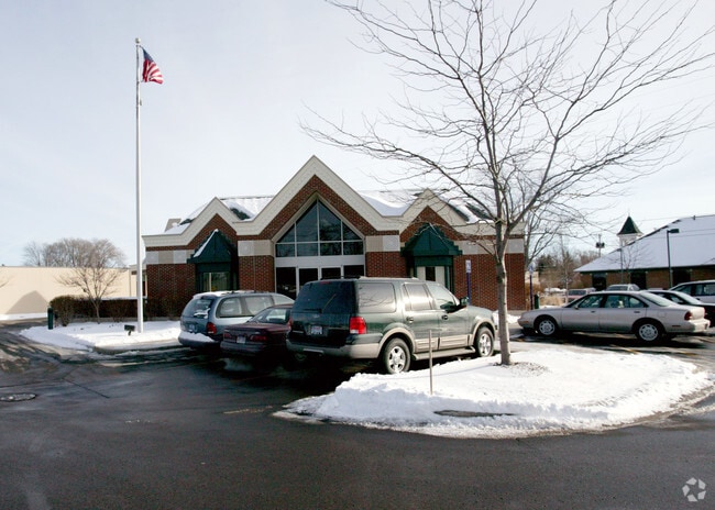
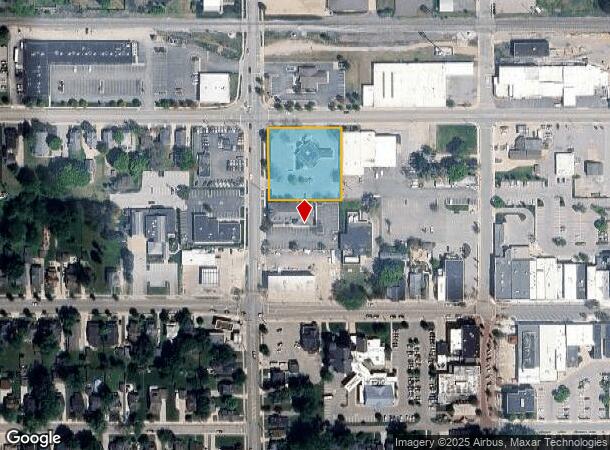
Property Record
41 N State St, Zeeland, MI 49464
NEARBY LISTINGS FOR SALE OR LEASE
Property Detail
41 N State St
Grand Rapids-Wyoming, MI
Hwy Keppels Add
70-17-18-356-051
W 21746 FT LOTS 10 & 11 EXC N 50 FT FOR HWY KEPPEL'S ADD
Financialbuilding
Ottawa
X
Michigan
26005C0050G
10-11
2024
1.05 AC
2025
Zeeland
022900
West Michigan
3,046 SF
DEMOGRAPHICS near 41 N State St
1 Mile
3 Mile
5 Mile
2024 Total Population
6,908
28,916
58,574
2029 Population
7,157
30,104
61,132
Pop Growth 2024-2029
+ 3.60%
+ 4.11%
+ 4.37%
Average Age
39
39
38
2024 Total Households
2,644
10,467
21,325
HH Growth 2024-2029
+ 3.74%
+ 4.24%
+ 4.59%
Median Household Inc
$73,074
$83,973
$75,891
Avg Household Size
2.50
2.70
2.60
2024 Avg HH Vehicles
2.00
2.00
2.00
Median Home Value
$236,741
$252,284
$246,095
Median Year Built
1971
1992
1990
Nearby Places
Map Layers
Map Styles
 Street
 Aerial
- Restaurants
- Banks
- Shops
- Fitness
- Groceries
PUBLIC TRANSPORTATION
COMMUTER RAIL
DRIVE
WALK
Distance
9 min
4.9 mi
AIRPORT
Gerald R Ford International
DRIVE
WALK
Distance
Gerald R Ford International
39 min
29.3 mi
Nearby Properties
Address
Land Use
TOTAL SIZE
Lot Size
Zoning
Address
Land Use
TOTAL SIZE
Lot Size
Zoning
1,134,118 SF
73.70 AC
I-2
Address
Land Use
TOTAL SIZE
Lot Size
Zoning
255,407 SF
23.18 AC
I-2
Address
Land Use
TOTAL SIZE
Lot Size
Zoning
349,583 SF
I
Address
Land Use
TOTAL SIZE
Lot Size
Zoning
662,015 SF
177 AC
SEE MAP
Address
Land Use
TOTAL SIZE
Lot Size
Zoning
716,625 SF
123.22 AC
I-2
Address
Land Use
TOTAL SIZE
Lot Size
Zoning
249,051 SF
24.77 AC
LDR
Address
Land Use
TOTAL SIZE
Lot Size
Zoning
594,031 SF
R-1
Address
Land Use
TOTAL SIZE
Lot Size
Zoning
218,722 SF
8.59 AC
AGR
Address
Land Use
TOTAL SIZE
Lot Size
Zoning
82,556 SF
Address
Land Use
TOTAL SIZE
Lot Size
Zoning
259,200 SF
R-1
Address
Land Use
TOTAL SIZE
Lot Size
Zoning
6,000 SF
46.50 AC
I-2
Address
Land Use
TOTAL SIZE
Lot Size
Zoning
226,347 SF
19.44 AC
I-2
Address
Land Use
TOTAL SIZE
Lot Size
Zoning
173,176 SF
28.57 AC
I-1
Address
Land Use
TOTAL SIZE
Lot Size
Zoning
132,127 SF
42.69 AC
SEE MAP
Address
Land Use
TOTAL SIZE
Lot Size
Zoning
35,715 SF
Address
Land Use
TOTAL SIZE
Lot Size
Zoning
230,020 SF
Address
Land Use
TOTAL SIZE
Lot Size
Zoning
109,988 SF
12.71 AC
OS-1
Address
Land Use
TOTAL SIZE
Lot Size
Zoning
136,520 SF
13.55 AC
PUD
Address
Land Use
TOTAL SIZE
Lot Size
Zoning
184,944 SF
12.57 AC
R-3
Address
Land Use
TOTAL SIZE
Lot Size
Zoning
3,880 SF
80 AC
RMH
Address
Land Use
TOTAL SIZE
Lot Size
Zoning
77,624 SF
27.32 AC
I-1
Address
Land Use
TOTAL SIZE
Lot Size
Zoning
50,000 SF
20.36 AC
I-2
Address
Land Use
TOTAL SIZE
Lot Size
Zoning
217,226 SF
20.82 AC
I-2
Address
Land Use
TOTAL SIZE
Lot Size
Zoning
181,847 SF
12.99 AC
I-1
Address
Land Use
TOTAL SIZE
Lot Size
Zoning
376,204 SF
20.10 AC
I-1
Address
Land Use
TOTAL SIZE
Lot Size
Zoning
Address
Land Use
TOTAL SIZE
Lot Size
Zoning
49,013 SF
11.76 AC
C-2
Address
Land Use
TOTAL SIZE
Lot Size
Zoning
1,240 SF
90.07 AC
PUD
Address
Land Use
TOTAL SIZE
Lot Size
Zoning
88,093 SF
Address
Land Use
TOTAL SIZE
Lot Size
Zoning
243,795 SF
17.31 AC
AG
The World's #1 Commercial Real Estate Marketplace
Connect with us
© 2025 CoStar Group
The information above has been obtained from sources believed reliable. While we do not doubt its accuracy we have not verified it and make no guarantee, warranty or representation about it. It is your responsibility to independently confirm its accuracy and completeness. Any projections, opinions, assumptions, or estimates used are for example only and do not represent the current or future performance of the property. The value of this transaction to you depends on tax and other factors which should be evaluated by your tax, financial, and legal advisors. You and your advisors should conduct a careful, independent investigation of the property to determine to your satisfaction the suitability of the property for your needs.