Property Record
41 Ogunquit Rd, Cape Neddick, ME 03902

Property Detail
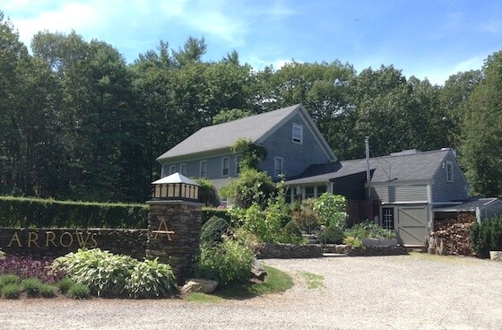
41 Ogunquit Rd
Restaurantbuilding
York
R2
Maine
B and X Area of moderate flood hazard, usually the area between the limits of the 100-year and 500-year floods.
2.91 AC
2025
York County
2025
Portland/South Portland
036002
Portland-South Portland, ME
4,573 SF
YORK-000099-000000-000047B
NEARBY LISTINGS FOR SALE OR LEASE
DEMOGRAPHICS near 41 Ogunquit Rd
1 mile
3 mile
5 mile
2025 Total Population
306
4,356
11,546
2030 Population
308
4,440
12,042
Pop Growth 2025-2030
+ 0.65%
+ 1.93%
+ 4.30%
Average Age
49
51
50
2025 Total Households
137
2,013
5,166
HH Growth 2025-2030
0.00%
+ 1.59%
+ 4.26%
Median Household Inc
$134,558
$122,967
$111,493
Avg Household Size
2.20
2.20
2.20
2025 Avg HH Vehicles
2.00
2.00
2.00
Median Home Value
$639,344
$657,865
$636,891
Median Year Built
1982
1985
1985
Nearby Places
Map Layers
Map Styles
 Street
 Aerial
Layers
 Traffic
 Biking
Places
Listings with unknown addresses are not visible on the map
- Restaurants
- Banks
- Shops
- Fitness
- Groceries
PUBLIC TRANSPORTATION
COMMUTER RAIL
Drive
Walk
Distance
19 min
8.4 mi
AIRPORT
Portsmouth International at Pease
Drive
Walk
Distance
Portsmouth International at Pease
32 min
17.6 mi
Portland International Jetport
Drive
Walk
Distance
Portland International Jetport
53 min
36.5 mi
Freight Ports
Portland, ME
Drive
Walk
Distance
Portland, ME
54 min
39.1 mi
SALE & LEASE HISTORY
LISTING DATE
SALE/LEASE

Sep 23, 2016
For Sale
May 31, 2017
For Sale
Dec 14, 2016
For Sale
Aug 16, 2024
For Sale
Nearby Properties
Address
Land Use
TOTAL SIZE
Lot Size
Zoning
Address
Land Use
TOTAL SIZE
Lot Size
Zoning
4.10 AC
LB/SLC
Address
Land Use
TOTAL SIZE
Lot Size
Zoning
4.64 AC
SLC/LB
Address
Land Use
TOTAL SIZE
Lot Size
Zoning
3.68 AC
SLC/GB
Address
Land Use
TOTAL SIZE
Lot Size
Zoning
2.63 AC
LBD/SL
Address
Land Use
TOTAL SIZE
Lot Size
Zoning
1.49 AC
SGD-1
Address
Land Use
TOTAL SIZE
Lot Size
Zoning
13.33 AC
R1-6
Address
Land Use
TOTAL SIZE
Lot Size
Zoning
4.65 AC
GBD2
Address
Land Use
TOTAL SIZE
Lot Size
Zoning
13.50 AC
SLC
Address
Land Use
TOTAL SIZE
Lot Size
Zoning
3.96 AC
GBD2
Address
Land Use
TOTAL SIZE
Lot Size
Zoning
3.78 AC
GBD2/R
Address
Land Use
TOTAL SIZE
Lot Size
Zoning
1.11 AC
LBD
Address
Land Use
TOTAL SIZE
Lot Size
Zoning
5.65 AC
GBD2
Address
Land Use
TOTAL SIZE
Lot Size
Zoning
4.66 AC
GBD2/R
Address
Land Use
TOTAL SIZE
Lot Size
Zoning
2.38 AC
SGD-2
Address
Land Use
TOTAL SIZE
Lot Size
Zoning
400 SF
0.36 AC
GB02
Address
Land Use
TOTAL SIZE
Lot Size
Zoning
2.07 AC
SLC
Address
Land Use
TOTAL SIZE
Lot Size
Zoning
1.79 AC
SLC
Address
Land Use
TOTAL SIZE
Lot Size
Zoning
4,718 SF
2.38 AC
SLR
Address
Land Use
TOTAL SIZE
Lot Size
Zoning
142 AC
RP
Address
Land Use
TOTAL SIZE
Lot Size
Zoning
3.53 AC
SLC/GB
Address
Land Use
TOTAL SIZE
Lot Size
Zoning
1.43 AC
SLC
Address
Land Use
TOTAL SIZE
Lot Size
Zoning
5.43 AC
GBD2/R
Address
Land Use
TOTAL SIZE
Lot Size
Zoning
24,555 SF
3.50 AC
GB
Address
Land Use
TOTAL SIZE
Lot Size
Zoning
2,264 SF
48.65 AC
GB
Address
Land Use
TOTAL SIZE
Lot Size
Zoning
0.89 AC
SLR/OF
Address
Land Use
TOTAL SIZE
Lot Size
Zoning
1,763 SF
28 AC
R
Address
Land Use
TOTAL SIZE
Lot Size
Zoning
7,728 SF
3 AC
SLC
Address
Land Use
TOTAL SIZE
Lot Size
Zoning
20,229 SF
0.64 AC
LBD
Address
Land Use
TOTAL SIZE
Lot Size
Zoning
11,100 SF
5.05 AC
GB
Address
Land Use
TOTAL SIZE
Lot Size
Zoning
12.85 AC
SLR/R
The World's #1 Commercial Real Estate Marketplace
Connect with us
© 2026 CoStar Group
The information above has been obtained from sources believed reliable. While we do not doubt its accuracy we have not verified it and make no guarantee, warranty or representation about it. It is your responsibility to independently confirm its accuracy and completeness. Any projections, opinions, assumptions, or estimates used are for example only and do not represent the current or future performance of the property. The value of this transaction to you depends on tax and other factors which should be evaluated by your tax, financial, and legal advisors. You and your advisors should conduct a careful, independent investigation of the property to determine to your satisfaction the suitability of the property for your needs.