Property Record
41 S Route 73 Ave, Hammonton, NJ 08037
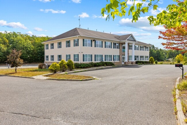

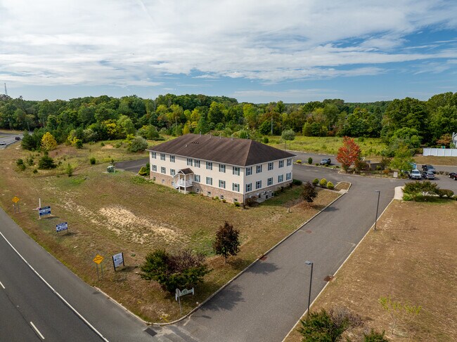
This Property Is For Sale
Property Detail
41 S Route 73 Ave
36-05006-0000-00014-05
FACILITY NAME: SCHOOL
Commercialnec
CAMDEN
PC1
New Jersey
B and X Area of moderate flood hazard, usually the area between the limits of the 100-year and 500-year floods.
14.5
2025
2.11 AC
2025
South Camden County
611500
Philadelphia
11,000 SF
Philadelphia-Camden-Wilmington, PA-NJ-DE-MD
NEARBY LISTINGS FOR SALE OR LEASE
DEMOGRAPHICS near 41 S Route 73 Ave
1 mile
3 mile
5 mile
2025 Total Population
2,982
13,903
52,263
2030 Population
3,043
14,188
53,616
Pop Growth 2025-2030
+ 2.05%
+ 2.05%
+ 2.59%
Average Age
43
42
41
2025 Total Households
1,075
5,057
19,078
HH Growth 2025-2030
+ 2.14%
+ 2.16%
+ 2.73%
Median Household Inc
$104,545
$93,893
$93,610
Avg Household Size
2.70
2.70
2.60
2025 Avg HH Vehicles
2.00
2.00
2.00
Median Home Value
$316,055
$288,486
$284,938
Median Year Built
1980
1978
1981
Nearby Places
Map Layers
Map Styles
 Street
 Aerial
Layers
 Traffic
 Biking
Places
Listings with unknown addresses are not visible on the map
- Restaurants
- Banks
- Shops
- Fitness
- Groceries
PUBLIC TRANSPORTATION
COMMUTER RAIL
Atco (Atlantic City Line - NJ Transit Commuter Rail (NJ Transit))
Drive
Walk
Distance
Atco (Atlantic City Line - NJ Transit Commuter Rail (NJ Transit))
8 min
5.4 mi
Hammonton (Atlantic City Line - NJ Transit Commuter Rail (NJ Transit))
Drive
Walk
Distance
Hammonton (Atlantic City Line - NJ Transit Commuter Rail (NJ Transit))
15 min
8.3 mi
AIRPORT
Atlantic City International
Drive
Walk
Distance
Atlantic City International
58 min
31.0 mi
Philadelphia International
Drive
Walk
Distance
Philadelphia International
49 min
31.5 mi
Freight Ports
Broadway Terminal - Pier 5
Drive
Walk
Distance
Broadway Terminal - Pier 5
30 min
21.9 mi
Nearby Properties
Address
Land Use
TOTAL SIZE
Lot Size
Zoning
Address
Land Use
TOTAL SIZE
Lot Size
Zoning
605.38 AC
ANC
Address
Land Use
TOTAL SIZE
Lot Size
Zoning
137.33 AC
PR3
Address
Land Use
TOTAL SIZE
Lot Size
Zoning
73.95 AC
PI3
Address
Land Use
TOTAL SIZE
Lot Size
Zoning
2,264 SF
21.47 AC
PR6
Address
Land Use
TOTAL SIZE
Lot Size
Zoning
20.02 AC
RPF
Address
Land Use
TOTAL SIZE
Lot Size
Zoning
89,672 SF
30.01 AC
PR2
Address
Land Use
TOTAL SIZE
Lot Size
Zoning
26.68 AC
PI2
Address
Land Use
TOTAL SIZE
Lot Size
Zoning
30 AC
PR2
Address
Land Use
TOTAL SIZE
Lot Size
Zoning
16,000 SF
13.22 AC
PC1
Address
Land Use
TOTAL SIZE
Lot Size
Zoning
1,718 SF
68.48 AC
PR2
Address
Land Use
TOTAL SIZE
Lot Size
Zoning
45.89 AC
PR1
Address
Land Use
TOTAL SIZE
Lot Size
Zoning
6.20 AC
Address
Land Use
TOTAL SIZE
Lot Size
Zoning
73.95 AC
PI3
Address
Land Use
TOTAL SIZE
Lot Size
Zoning
Address
Land Use
TOTAL SIZE
Lot Size
Zoning
720.84 AC
PRC
Address
Land Use
TOTAL SIZE
Lot Size
Zoning
10.72 AC
PI1
Address
Land Use
TOTAL SIZE
Lot Size
Zoning
109.70 AC
PA
Address
Land Use
TOTAL SIZE
Lot Size
Zoning
3,100 SF
1 AC
PA
Address
Land Use
TOTAL SIZE
Lot Size
Zoning
21,116 SF
4.67 AC
PC2
Address
Land Use
TOTAL SIZE
Lot Size
Zoning
85.89 AC
PI
Address
Land Use
TOTAL SIZE
Lot Size
Zoning
54,547 SF
6.22 AC
PC1
Address
Land Use
TOTAL SIZE
Lot Size
Zoning
57,854 SF
13.89 AC
PC1
Address
Land Use
TOTAL SIZE
Lot Size
Zoning
9,170 SF
15.67 AC
PI3
Address
Land Use
TOTAL SIZE
Lot Size
Zoning
21 AC
PR1
Address
Land Use
TOTAL SIZE
Lot Size
Zoning
2.29 AC
Address
Land Use
TOTAL SIZE
Lot Size
Zoning
12,320 SF
23.25 AC
PI1
Address
Land Use
TOTAL SIZE
Lot Size
Zoning
10,787 SF
PC12
Address
Land Use
TOTAL SIZE
Lot Size
Zoning
17.74 AC
PR1
Address
Land Use
TOTAL SIZE
Lot Size
Zoning
12,628 SF
5 AC
PC2
Address
Land Use
TOTAL SIZE
Lot Size
Zoning
11.05 AC
PI3
The World's #1 Commercial Real Estate Marketplace
Connect with us
© 2026 CoStar Group
The information above has been obtained from sources believed reliable. While we do not doubt its accuracy we have not verified it and make no guarantee, warranty or representation about it. It is your responsibility to independently confirm its accuracy and completeness. Any projections, opinions, assumptions, or estimates used are for example only and do not represent the current or future performance of the property. The value of this transaction to you depends on tax and other factors which should be evaluated by your tax, financial, and legal advisors. You and your advisors should conduct a careful, independent investigation of the property to determine to your satisfaction the suitability of the property for your needs.