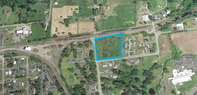
Property Record
412 Oakhurst Dr, Elma, WA 98541

NEARBY LISTINGS FOR SALE OR LEASE
-
-
View all Elma listings for sale on LoopNet.com
Property Detail
412 Oakhurst Dr
Aberdeen, WA
Elma
618063512007
EL AC TAX 60
Vacantlandnec
Grays Harbor
X
Washington
53027C0769E
120
2025
1.30 AC
2025
Washington State Area
000502
Other Market Areas
DEMOGRAPHICS near 412 Oakhurst Dr
1 Mile
3 Mile
5 Mile
2024 Total Population
2,622
6,302
7,896
2029 Population
2,688
6,529
8,201
Pop Growth 2024-2029
+ 2.52%
+ 3.60%
+ 3.86%
Average Age
39
40
41
2024 Total Households
993
2,350
2,949
HH Growth 2024-2029
+ 2.42%
+ 3.57%
+ 3.83%
Median Household Inc
$68,871
$69,374
$70,292
Avg Household Size
2.60
2.60
2.60
2024 Avg HH Vehicles
2.00
2.00
2.00
Median Home Value
$319,298
$334,672
$345,904
Median Year Built
1973
1976
1977
Nearby Places
Map Layers
Map Styles
 Street
 Aerial
- Restaurants
- Banks
- Shops
- Fitness
- Groceries
SALE & LEASE HISTORY
LISTING DATE
SALE/LEASE

Nov 22, 2019
For Sale
Jan 29, 2018
For Sale
Nearby Properties
Address
Land Use
TOTAL SIZE
Lot Size
Zoning
Address
Land Use
TOTAL SIZE
Lot Size
Zoning
26.50 AC
G5
Address
Land Use
TOTAL SIZE
Lot Size
Zoning
100,522 SF
22.33 AC
Address
Land Use
TOTAL SIZE
Lot Size
Zoning
2,480 SF
16.50 AC
Address
Land Use
TOTAL SIZE
Lot Size
Zoning
69,240 SF
45.79 AC
RR
Address
Land Use
TOTAL SIZE
Lot Size
Zoning
106,280 SF
10.50 AC
Address
Land Use
TOTAL SIZE
Lot Size
Zoning
21,144 SF
53.05 AC
RR
Address
Land Use
TOTAL SIZE
Lot Size
Zoning
6.36 AC
Address
Land Use
TOTAL SIZE
Lot Size
Zoning
4,500 SF
3.99 AC
R2
Address
Land Use
TOTAL SIZE
Lot Size
Zoning
36,902 SF
1.22 AC
Address
Land Use
TOTAL SIZE
Lot Size
Zoning
46,960 SF
3.31 AC
RR
Address
Land Use
TOTAL SIZE
Lot Size
Zoning
14.71 AC
R2
Address
Land Use
TOTAL SIZE
Lot Size
Zoning
5,916 SF
10.45 AC
R2
Address
Land Use
TOTAL SIZE
Lot Size
Zoning
90,190 SF
17.35 AC
A1
Address
Land Use
TOTAL SIZE
Lot Size
Zoning
35,639 SF
1.03 AC
Address
Land Use
TOTAL SIZE
Lot Size
Zoning
2.33 AC
Address
Land Use
TOTAL SIZE
Lot Size
Zoning
26,472 SF
2.32 AC
Address
Land Use
TOTAL SIZE
Lot Size
Zoning
22,417 SF
4.90 AC
Address
Land Use
TOTAL SIZE
Lot Size
Zoning
4,983 SF
11.22 AC
A1
Address
Land Use
TOTAL SIZE
Lot Size
Zoning
23,844 SF
0.86 AC
Address
Land Use
TOTAL SIZE
Lot Size
Zoning
34,148 SF
7.36 AC
Address
Land Use
TOTAL SIZE
Lot Size
Zoning
15,848 SF
5.66 AC
Address
Land Use
TOTAL SIZE
Lot Size
Zoning
46,674 SF
7 AC
I2
Address
Land Use
TOTAL SIZE
Lot Size
Zoning
844 SF
2.17 AC
I2
Address
Land Use
TOTAL SIZE
Lot Size
Zoning
20,600 SF
1.78 AC
Address
Land Use
TOTAL SIZE
Lot Size
Zoning
14,300 SF
4.30 AC
Address
Land Use
TOTAL SIZE
Lot Size
Zoning
20,480 SF
1.41 AC
Address
Land Use
TOTAL SIZE
Lot Size
Zoning
25,462 SF
4.30 AC
G5
Address
Land Use
TOTAL SIZE
Lot Size
Zoning
40,357 SF
5.89 AC
Address
Land Use
TOTAL SIZE
Lot Size
Zoning
8,100 SF
0.30 AC
Address
Land Use
TOTAL SIZE
Lot Size
Zoning
4,290 SF
0.41 AC
The World's #1 Commercial Real Estate Marketplace
Connect with us
© 2026 CoStar Group
The information above has been obtained from sources believed reliable. While we do not doubt its accuracy we have not verified it and make no guarantee, warranty or representation about it. It is your responsibility to independently confirm its accuracy and completeness. Any projections, opinions, assumptions, or estimates used are for example only and do not represent the current or future performance of the property. The value of this transaction to you depends on tax and other factors which should be evaluated by your tax, financial, and legal advisors. You and your advisors should conduct a careful, independent investigation of the property to determine to your satisfaction the suitability of the property for your needs.